Category:2020 maps of Canada
| ← 2020 2021 2022 2023 2024 |
English: Maps of Canada from 2020 or related to Canada in 2020
Français : Les cartes du Canada de 2020 ou se rapportant au Canada en 2020
Media in category "2020 maps of Canada"
The following 6 files are in this category, out of 6 total.
-
 2023 Titan submersible incident map.svg 512 × 512; 667 KB
-
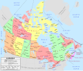 Canada political map - en.svg 1,114 × 942; 423 KB
-
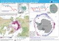 ECDM 2020021 Actic Antarctic.pdf 2,479 × 1,754; 759 KB
-
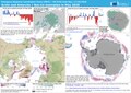 ECDM 20200617 Actic Antarctic.pdf 2,479 × 1,754; 752 KB
-
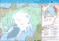 ECDM 20200717 Arctic Wildfires.pdf 1,625 × 1,125; 602 KB
-
 OpenStreetMap 10 St. Mary Street Toronto as seen in 2020.jpg 1,100 × 723; 124 KB


