Category:2020 maps of the United States
States of the United States: Alabama · Arizona · California · Iowa · Louisiana · Massachusetts · New York · Utah · Wyoming
Subcategories
This category has the following 10 subcategories, out of 10 total.
A
- 2020 maps of Arizona (empty)
C
- 2020 maps of California (8 F)
I
L
- 2020 maps of Louisiana (4 F)
M
- 2020 maps of Massachusetts (8 F)
N
U
- 2020 maps of Utah (2 F)
W
- 2020 maps of Wyoming (1 F)
Media in category "2020 maps of the United States"
The following 18 files are in this category, out of 18 total.
-
 Black Americans 2020 County.png 15,610 × 8,900; 11.69 MB
-
 Census tracts of Minnesota by percent non-Hispanic White alone, 2020.svg 512 × 327; 1.61 MB
-
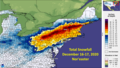 December 16-17 nor'easter snowfall totals map.png 1,240 × 702; 132 KB
-
 Fema regions map.png 1,436 × 940; 161 KB
-
 Georgia House of Representatives 2020.png 1,474 × 1,356; 453 KB
-
 Intensitée du Smog sur base des données du 13 Septembre 2020.png 6,900 × 4,275; 4.33 MB
-
 Intentional Homicide Rate by U.S. State.svg 1,199 × 593; 72 KB
-
 Life expectancy map of USA 2020 with names.png 5,000 × 3,500; 1.15 MB
-
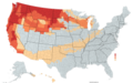
 Life expectancy map of USA 2020.png 5,000 × 3,500; 1.04 MB
-
 MidwesternLegislatures2020.png 1,244 × 980; 18 KB
-
 Miss America's Outstanding Teen 2020 Placements.png 5,285 × 3,762; 1.32 MB
-
 Population Change (2020 US Census).png 5,285 × 3,762; 1.24 MB
-
 Race and Ethnicity in Connecticut in 2020.png 14,400 × 10,800; 11.64 MB
-
 Severe Weather For the 29th.jpg 815 × 555; 71 KB
-
 Spread of COVID-19 in the United States.gif 959 × 593; 1.74 MB
-
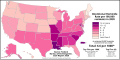
 State's that have had African American senators.png 1,747 × 1,080; 425 KB
-
 Unemployment by county in the United States.png 1,328 × 810; 572 KB
-
 Violent Crime Rate by U.S. state.svg 1,199 × 593; 72 KB


.png)


