Category:20th-century maps of Moldova
Countries of Europe: Albania · Armenia‡ · Austria · Azerbaijan‡ · Belarus · Belgium · Bosnia and Herzegovina · Bulgaria · Croatia · Cyprus‡ · Czech Republic · Denmark · Estonia · Finland · France‡ · Georgia‡ · Germany · Greece · Hungary · Iceland · Republic of Ireland · Italy · Kazakhstan‡ · Latvia · Lithuania · Luxembourg · Moldova · Montenegro · Netherlands‡ · North Macedonia · Norway · Poland · Portugal‡ · Romania · Russia‡ · Serbia · Slovakia · Slovenia · Spain‡ · Sweden · Switzerland · Turkey‡ · Ukraine · United Kingdom
Specific status: Isle of Man – Limited recognition: Abkhazia‡
‡: partly located in Europe
Specific status: Isle of Man – Limited recognition: Abkhazia‡
‡: partly located in Europe
Media in category "20th-century maps of Moldova"
The following 12 files are in this category, out of 12 total.
-
 1916 ethnographical map of Bessarabia.jpg 9,503 × 11,337; 16.67 MB
-
 1918 Împărțirea administrativă a Republicii Democratice Moldovenești în 1917.jpg 1,180 × 1,253; 355 KB
-
 1919 ethnographical map of Bessarabia.jpg 7,846 × 9,500; 9.4 MB
-
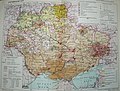
 Карта Бессарабии из атласа 1940.png 899 × 1,009; 1.61 MB
-
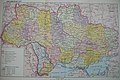 Ukrainian RSR 1947.jpg 3,072 × 2,059; 1.11 MB
-
 Map of the Moldavian ASSR.jpg 3,451 × 5,679; 4.44 MB
-
 Map of Ukraine MASSR 1939.jpg 1,100 × 1,311; 437 KB
-
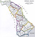
 Massr map.png 2,040 × 3,177; 650 KB
-
 MASSR.JPG 1,194 × 1,698; 442 KB
-
 Mold1917.jpg 1,180 × 1,253; 431 KB
-
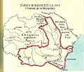 Romania la 1913.jpg 549 × 471; 145 KB
-
 Ukrainian RSR 1939.jpg 2,803 × 2,135; 1.24 MB


