Category:Acton Trussell
village in United Kingdom  | |||||
| Upload media | |||||
| Instance of | |||||
|---|---|---|---|---|---|
| Location | Acton Trussell and Bednall, South Staffordshire, Staffordshire, West Midlands, England | ||||
 | |||||
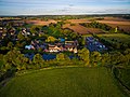
English: Acton Trussell is a village in the English county of Staffordshire. It is known as Actone in the Domesday Book. Located around 4 miles southeast of Stafford, it is an affluent village, with many large homes but few local amenities (except for a Post Office which opens Tuesdays and Thursdays). Residents in this village have excellent views of Staffordshire farmland and Stafford Castle in the distance. Its close proximity to the M6 motorway (Junction 13) makes it a very convenient location for commuters. The majority of commuting from the village takes place to the areas of southern Staffordshire, eastern Shropshire and the West Midlands conurbation.
Media in category "Acton Trussell"
The following 59 files are in this category, out of 59 total.
-
 Acton Mill Bridge.jpg 640 × 480; 277 KB
-

-

-

-
 Acton Trussell - The Moat House (29880085600).jpg 3,992 × 2,992; 9.52 MB
-
 Acton Trussell Moat House.JPG 838 × 507; 110 KB
-
 Boat maintenance, near Acton Trussell, Staffordshire - geograph.org.uk - 1478993.jpg 1,440 × 970; 1.84 MB
-

-
 Canalside living, Acton Trussell style - geograph.org.uk - 1335490.jpg 640 × 425; 116 KB
-
 Heading to Lower Drayton Farm - geograph.org.uk - 1435281.jpg 640 × 601; 54 KB
-
 Holiday Inn Express, Acton Court - geograph.org.uk - 250543.jpg 640 × 480; 51 KB
-
 Lower Penkridge Road, Acton Trussell - geograph.org.uk - 968580.jpg 640 × 480; 70 KB
-
 Lower Penkridge Road, Acton Trussell. - geograph.org.uk - 1580269.jpg 640 × 480; 107 KB
-

-
 M6 from the Staffs and Worcs Canal - geograph.org.uk - 1335477.jpg 640 × 425; 75 KB
-

-

-

-
 Mill Lane at A449 roundabout. - geograph.org.uk - 1580275.jpg 640 × 480; 65 KB
-
 Mill Lane, Acton Trussell - geograph.org.uk - 968589.jpg 640 × 480; 64 KB
-
 Moat House, Acton Trussel.jpg 2,048 × 1,536; 642 KB
-
 Old School House, Acton Trussell.jpg 1,024 × 683; 1 MB
-

-

-

-

-

-

-

-

-
 Staffs and Worcs Canal at Acton Trussell - geograph.org.uk - 1335484.jpg 640 × 425; 102 KB
-
 Taking their time - geograph.org.uk - 700048.jpg 640 × 426; 114 KB
-
 Teddesley Bridge - geograph.org.uk - 415998.jpg 640 × 480; 125 KB
-
 Teddesley Bridge - geograph.org.uk - 416027.jpg 640 × 480; 151 KB
-
 Telephone Kiosk, Acton Trussell.jpg 683 × 1,024; 397 KB
-
 The Moat House Hotel, Acton Trussell - geograph.org.uk - 968572.jpg 640 × 480; 92 KB
-
 The Moat house, Acton Trussell - geograph.org.uk - 778328.jpg 640 × 443; 122 KB
-
 Trees at Junction 13, M6 - geograph.org.uk - 250531.jpg 640 × 480; 88 KB
-
 Ash Flats Lane bridge over M6 - geograph.org.uk - 250776.jpg 640 × 480; 62 KB
-
 Bridge 88 - geograph.org.uk - 416007.jpg 640 × 480; 129 KB
-
 Chase View Lane, towards Ash Flats - geograph.org.uk - 250775.jpg 640 × 480; 112 KB
-
 Dryad's Saddle Fungus - geograph.org.uk - 552410.jpg 640 × 480; 128 KB
-
 Large mushrooms by the roadside - geograph.org.uk - 250079.jpg 640 × 480; 84 KB
-

-
 Roundabout, M6 junction 13 - geograph.org.uk - 250550.jpg 640 × 480; 68 KB
-
 Slip road from M6 northbound, junction 13 - geograph.org.uk - 250547.jpg 640 × 480; 117 KB
-

-

-
 Square Orange, Acton Court - geograph.org.uk - 250529.jpg 640 × 455; 79 KB
-

-

-

-
 Staffordshire Way, Teddesley - geograph.org.uk - 271690.jpg 640 × 480; 115 KB
-
 Steps down from Ash Flats Lane - geograph.org.uk - 250779.jpg 480 × 640; 130 KB
-
 The A449 at Dunston - geograph.org.uk - 250538.jpg 640 × 480; 96 KB
-

-

-

-


.jpg)


