Category:Dorfkirche Kagel
| Object location | | View all coordinates using: OpenStreetMap |
|---|
This is the category of the Brandenburger Baudenkmal (cultural heritage monument) with the ID 09115494 (Wikidata)
|
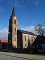
church building in Brandenburg state, Germany  | |||||
| Upload media | |||||
| Instance of | |||||
|---|---|---|---|---|---|
| Part of | |||||
| Location | Kagel, Grünheide (Mark), Oder-Spree District, Brandenburg, Germany | ||||
| Heritage designation | |||||
 | |||||
Deutsch: Ansichten der Kirche in Kagel , Gemeinde Grünheide , Landkreis Oder-Spree , Land Brandenburg, Deutschland.
English: Pictures of the church in Kagel , Grünheide municipality , Oder-Spree district, Brandenburg state, Germany
Français : Photos de l'église à Kagel , commune de Grünheide , arrondissement de Oder-Spree , état fédéral de Brandebourg, Allemagne
Pages in category "Dorfkirche Kagel"
This category contains only the following page.
Media in category "Dorfkirche Kagel"
The following 24 files are in this category, out of 24 total.
-
 Dorfkirche Kagel 2018 NE.jpg 4,178 × 4,394; 7.8 MB
-
 Dorfkirche Kagel 2018 SE.jpg 3,648 × 4,864; 7.91 MB
-
 Dorfkirche Kagel 2018 SW.jpg 3,648 × 4,864; 4.92 MB
-
 Dorfkirche Kagel 2018 vermauertes Nordportal.jpg 3,530 × 4,778; 6.76 MB
-
 Dorfkirche Kagel 2018 Westportal.jpg 3,648 × 4,864; 8.05 MB
-
 Dorfkirche Kagel 1.JPG 3,072 × 4,608; 6.27 MB
-
 Dorfkirche Kagel 3.JPG 3,072 × 4,608; 7.71 MB
-
 Dorfkirche Kagel 5.JPG 3,072 × 4,608; 5.68 MB
-
 Dorfkirche Kagel 6.JPG 4,608 × 3,072; 7.27 MB
-
 Dorfkirche Kagel 7.JPG 3,072 × 4,608; 7.18 MB
-
 Dorfkirche Kagel 8.JPG 4,608 × 3,072; 7.72 MB
-
 Dorfkirche Kagel Kirchenschiff Nordansicht Richtung Chor.jpg 3,024 × 4,032; 3.74 MB
-
 Dorfkirche Kagel Kirchenschiff Nordwestansicht.jpg 4,032 × 3,024; 4.95 MB
-
 Dorfkirche Kagel Kirchenschiff Südwestseite.jpg 4,032 × 3,024; 4.93 MB
-
 Dorfkirche Kagel Nordostansicht.jpg 3,024 × 4,032; 3.32 MB
-
 Dorfkirche Kagel Ostansicht.jpg 3,024 × 4,032; 4.4 MB
-
 Dorfkirche Kagel Westansicht.jpg 3,024 × 4,032; 2.17 MB
-
 Dorfkirche Kagel Westportal.jpg 3,024 × 4,032; 3.09 MB
-
 Dorfkirche Kagel Westturm Nordwestansicht.jpg 3,024 × 4,032; 2.06 MB
-
 Dorfkirche Kagel Westturm Südwestansicht.jpg 3,024 × 4,032; 3.13 MB
-
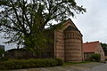
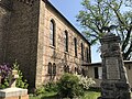
 Ensemble Dorfkirche - Schulhaus und Kriegerdenkmal Kagel 1.JPG 4,608 × 3,072; 5.39 MB
-
 Ensemble Dorfkirche - Schulhaus und Kriegerdenkmal Kagel 2.JPG 4,608 × 3,072; 7.54 MB
-
 Ensemble Dorfkirche - Schulhaus und Kriegerdenkmal Kagel 3.JPG 4,608 × 3,072; 5.6 MB
-
 Ensemble Dorfkirche - Schulhaus und Kriegerdenkmal Kagel 5.JPG 4,608 × 3,072; 5.88 MB


