Category:Election maps of Suriname
Countries of the Americas: Antigua and Barbuda · Argentina · The Bahamas · Barbados · Belize · Bolivia · Brazil · Canada · Chile · Colombia · Costa Rica · Cuba · Dominica · Dominican Republic · Ecuador · El Salvador · Grenada · Guatemala · Guyana · Haiti · Honduras · Jamaica · Mexico · Nicaragua · Panama · Paraguay · Peru · Saint Kitts and Nevis · Saint Lucia · Saint Vincent and the Grenadines · Suriname · Trinidad and Tobago · United States of America · Uruguay · Venezuela
Other areas: Anguilla · Bermuda · British Virgin Islands · Cayman Islands · Falkland Islands · French Guiana · Greenland · Guadeloupe · Martinique · Montserrat · Puerto Rico · Saint Barthélemy · Saint-Martin · Saint Pierre and Miquelon · Turks and Caicos Islands · United States Virgin Islands
Other areas: Anguilla · Bermuda · British Virgin Islands · Cayman Islands · Falkland Islands · French Guiana · Greenland · Guadeloupe · Martinique · Montserrat · Puerto Rico · Saint Barthélemy · Saint-Martin · Saint Pierre and Miquelon · Turks and Caicos Islands · United States Virgin Islands
Media in category "Election maps of Suriname"
The following 3 files are in this category, out of 3 total.
-
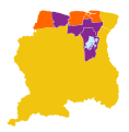 2020 Surinamese general election - Most voted party by district.svg 1,181 × 1,205; 328 KB
-
 2020 Surinamese general election - Results.svg 512 × 473; 268 KB
-
 2020 Zetels in DNA.jpg 2,200 × 2,544; 352 KB


