Category:Former Royal School for the Blind, Hardman Street
| Object location | | View all coordinates using: OpenStreetMap |
|---|
architectural structure in Liverpool, Merseyside, UK  | |||||
| Upload media | |||||
| Instance of | |||||
|---|---|---|---|---|---|
| Location | Liverpool, Merseyside, North West England, England | ||||
| Heritage designation |
| ||||
 | |||||
Media in category "Former Royal School for the Blind, Hardman Street"
The following 12 files are in this category, out of 12 total.
-
 Blind School Hardman Street .jpg 1,024 × 623; 93 KB
-
 Building on the corner of Hope Street and Hardman Street, Liverpool.JPG 4,320 × 3,240; 2.93 MB
-
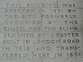 Chapel for the Blind Liverpool inscription.jpg 984 × 742; 520 KB
-
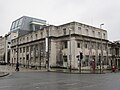
 Former Royal School for the Blind, Hardman Street.jpg 4,624 × 3,465; 6 MB
-
 Frontage, Royal School for the Blind, Hardman Street.jpg 5,130 × 2,628; 6.34 MB
-
 Going Downhill (218909651).jpeg 2,048 × 2,043; 1.35 MB
-
 Hardman Street Blind School.jpg 1,455 × 2,000; 528 KB
-
 Liverpool Blind School, Hardman Street stitch.jpg 6,167 × 2,661; 7.54 MB
-
 Merseyside Trade Union building, Hardman Street, Liverpool (1).JPG 4,320 × 3,240; 3.07 MB
-
 Merseyside Trade Union building, Hardman Street, Liverpool (2).JPG 4,320 × 3,240; 3.05 MB
-
 Plaque, Royal School for the Blind, Hardman Street.jpg 4,708 × 2,719; 8.17 MB
-
 The old blind school in Liverpool - Flickr - odako1.jpg 3,488 × 5,232; 4.63 MB


.jpeg)

.JPG)
.JPG)

