Category:Royal School for the Blind, Liverpool
| Object location | | View all coordinates using: OpenStreetMap |
|---|
special needs school in Liverpool, UK  .jpg) | |||||
| Upload media | |||||
| Instance of | |||||
|---|---|---|---|---|---|
| Location | |||||
| Street address |
| ||||
| Inception |
| ||||
| official website | |||||
 | |||||
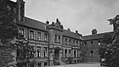
The Royal School for the Blind, Liverpool, was founded in 1791 in Commutation Row, Liverpool city centre. It moved to this building, the former Wavertree Hall, in 1898. The "Royal" prefix was authorised by Queen Elizabeth II in 1966.
Media in category "Royal School for the Blind, Liverpool"
The following 9 files are in this category, out of 9 total.
-
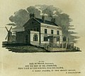 Blind School 1805.jpg 1,200 × 1,068; 190 KB
-
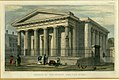 Blind school chapel 1829.jpg 1,200 × 801; 215 KB
-
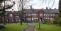 Royal School for the Blind 2020.jpg 5,085 × 2,584; 18.62 MB
-
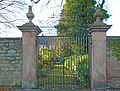 Royal School for the Blind, Liverpool gates.jpg 4,816 × 3,640; 9.79 MB
-
 Royal School for the Blind, Liverpool main.jpg 5,152 × 3,864; 13.16 MB
-
 Royal School for the Blind, Liverpool plaque (cropped).jpg 1,449 × 1,089; 1.32 MB
-
 Royal School for the Blind, Liverpool plaque.jpg 5,152 × 3,864; 7.41 MB
-
 Wavertree School.jpg 660 × 371; 37 KB
-
 WavertreeSchoolfortheBlind.tif 630 × 411; 343 KB


