Category:Geological maps of Louisiana
States of the United States: Alabama · Alaska · Arizona · Arkansas · California · Colorado · Connecticut · Delaware · Florida · Georgia · Hawaii · Idaho · Illinois · Indiana · Iowa · Kansas · Kentucky · Louisiana · Maine · Maryland · Massachusetts · Michigan · Minnesota · Mississippi · Missouri · Montana · Nebraska · Nevada · New Hampshire · New Jersey · New Mexico · New York · North Carolina · North Dakota · Ohio · Oklahoma · Oregon · Pennsylvania · Rhode Island · South Carolina · South Dakota · Tennessee · Texas · Utah · Vermont · Virginia · Washington · West Virginia · Wisconsin · Wyoming
Puerto Rico
Puerto Rico
Subcategories
This category has only the following subcategory.
*
Media in category "Geological maps of Louisiana"
The following 12 files are in this category, out of 12 total.
-
 Bulletin of the Geological Society of America (1917) (20449555995).jpg 3,272 × 2,304; 1.36 MB
-
 Coastal changediagram4.jpg 2,550 × 1,650; 838 KB
-
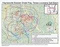 Haynesville Shale Map.pdf 1,650 × 1,275; 362 KB
-
 Haynesville Shale Map.png 1,650 × 1,275; 667 KB
-
 LAHydrocarbonPlaysVer001.png 2,203 × 1,842; 1.16 MB
-
 Miss lobe.jpg 2,169 × 1,682; 1.08 MB
-
 Mississippi Delta Lobes.jpg 800 × 484; 73 KB
-
 Red River, Louisiana Deposits1.jpg 5,341 × 6,771; 6.82 MB
-
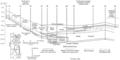 Smackover and Bossier Formations geologic cross section.png 994 × 499; 81 KB
-
 Smackover Formation areal extent.png 1,180 × 473; 820 KB
-
 Texas seismicity map.pdf 1,800 × 1,350; 2.15 MB
-
 USGS Landscape landloss WetlandLoss Red Louisiana.jpg 1,000 × 333; 160 KB
_(20449555995).jpg)


