Category:Grade II listed bridges in Nottinghamshire
Ceremonial counties of England: Bedfordshire · Berkshire · Buckinghamshire · Cambridgeshire · Cheshire · Cornwall · Cumbria · Derbyshire · Devon · Dorset · Durham · East Riding of Yorkshire · Essex · Gloucestershire · Greater London · Greater Manchester · Hampshire · Herefordshire · Hertfordshire · Kent · Lancashire · Leicestershire · Lincolnshire · Merseyside · Norfolk · North Yorkshire · Northamptonshire · Northumberland · Nottinghamshire · Oxfordshire · Rutland · Shropshire · Somerset · South Yorkshire · Staffordshire · Suffolk · Surrey · Tyne and Wear · Warwickshire · West Midlands · West Sussex · West Yorkshire · Wiltshire · Worcestershire
City-counties: Bristol ·
Former historic counties:
Other former counties:
City-counties: Bristol ·
Former historic counties:
Other former counties:
Subcategories
This category has the following 13 subcategories, out of 13 total.
B
- Bawtry Bridge (4 F)
D
- Drury Dam Viaduct (16 F)
K
- Kegworth Bridge (9 F)
L
- Longstone Bridge (25 F)
M
- Mansfield Railway Viaduct (23 F)
P
R
- Rectory Junction Viaduct (11 F)
S
- Smeaton's Arches (7 F)
T
- Trent Bridge, Newark-on-Trent (32 F)
W
- Wilford Suspension Bridge (74 F)
- Wiseton Top Bridge (8 F)
Media in category "Grade II listed bridges in Nottinghamshire"
The following 55 files are in this category, out of 55 total.
-

-
 Bridge 32, Clark's Bridge - geograph.org.uk - 944763.jpg 640 × 453; 119 KB
-
 Bridge 47 Chesterfield Canal - geograph.org.uk - 113912.jpg 640 × 427; 139 KB
-
 Bridge 62 - geograph.org.uk - 2744465.jpg 1,024 × 768; 178 KB
-

-
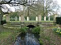
 Bridge in Highfields Park - geograph.org.uk - 680887.jpg 640 × 420; 111 KB
-
 Bridge Number 51 - Ranby - geograph.org.uk - 2012868.jpg 800 × 531; 126 KB
-

-
 Bridge over Church Lane - geograph.org.uk - 2486479.jpg 1,024 × 768; 326 KB
-
 Bridge over Grassthorpe Beck - geograph.org.uk - 2907593.jpg 3,648 × 2,736; 2.93 MB
-
 Bridge over Red Hill Lock - geograph.org.uk - 1886159.jpg 1,024 × 683; 417 KB
-
 Bridge over River Meden.jpg 4,981 × 3,583; 4.4 MB
-
 Bridge over the Crock Dumble stream - geograph.org.uk - 1167428.jpg 1,280 × 960; 382 KB
-
 Bridge Over the Leen, Bulwell - geograph.org.uk - 949885.jpg 640 × 480; 122 KB
-
 Bridge over the River Meden - geograph.org.uk - 4754224.jpg 2,589 × 1,479; 2.74 MB
-
 Bridge over the River Ryton.jpg 640 × 480; 146 KB
-
 Bridge over Tottle Brook.jpg 1,280 × 960; 582 KB
-
 Bridge, Thoresby Park.jpg 1,024 × 768; 1.74 MB
-
 Budby Bridge, Worksop Road, Budby (1).jpg 3,432 × 3,045; 3.33 MB
-
 Bulwell Bogs Park - geograph.org.uk - 4484698.jpg 1,024 × 732; 1.23 MB
-
 Carburton Bridge ... - geograph.org.uk - 93057.jpg 640 × 482; 83 KB
-
 Carlton Mill - geograph.org.uk - 125617.jpg 640 × 480; 88 KB
-
 Carlton Mill and the stream - geograph.org.uk - 2058058.jpg 800 × 551; 111 KB
-
 Castle and Middle Bridge.jpg 3,950 × 2,793; 7.89 MB
-
 Causeway Arches, Newark.jpg 800 × 600; 86 KB
-
 Church Road, Church Warsop, Notts. - geograph.org.uk - 4803196.jpg 3,491 × 2,799; 1.83 MB
-
 Eel Pie Bridge - geograph.org.uk - 1758028.jpg 640 × 426; 105 KB
-
 Haxey Gate Bridge - geograph.org.uk - 3941993.jpg 5,184 × 3,456; 4.16 MB
-
 Kegworth Bridge - geograph.org.uk - 2240660.jpg 1,024 × 768; 234 KB
-
 Lady's Bridge. - geograph.org.uk - 426491.jpg 640 × 480; 453 KB
-
 Lecture Room Bridge, Hayton - geograph.org.uk - 4197394.jpg 1,280 × 947; 806 KB
-
 Longstone Bridge - geograph.org.uk - 3112507.jpg 1,280 × 960; 274 KB
-

-
 Nottingham Arboretum - geograph.org.uk - 790123.jpg 640 × 480; 138 KB
-
 Nottingham Canal, Bridge 2 - geograph.org.uk - 1890822.jpg 800 × 600; 501 KB
-
 Old Trent Bridge - geograph.org.uk - 5030963.jpg 1,024 × 637; 200 KB
-
 Otter's Bridge, Clayworth - geograph.org.uk - 4199474.jpg 1,280 × 960; 701 KB
-
 Packhorse Bridge Redhill Lock.jpg 3,904 × 2,928; 3.29 MB
-
 Perlethorpe Bridge.jpg 4,032 × 3,024; 3.69 MB
-
 Pleasley Bridge, Grade II listed building, Pleasley, Mansfield.jpg 4,048 × 3,036; 5 MB
-
 Potwell Dyke Bridge.jpg 1,280 × 960; 712 KB
-
 Railway Bridge Behind Hermitage Mill - geograph.org.uk - 2615158.jpg 2,048 × 1,536; 754 KB
-
 Railway Bridge, Newstead.jpg 1,024 × 768; 366 KB
-
 Smeaton's arches, near Muskham Bridge - geograph.org.uk - 3138239.jpg 1,280 × 960; 280 KB
-
 Smite Aqueduct.jpg 1,280 × 960; 562 KB
-
 Snape Lane bridge - geograph.org.uk - 4260464.jpg 1,280 × 915; 505 KB
-
 South Footbridge, Boating Lake, Nottingham.jpg 1,280 × 960; 561 KB
-
 Swallow Bridge, No 82, on Chesterfield Canal - geograph.org.uk - 3636956.jpg 4,000 × 2,248; 5.28 MB
-
 Swancar Bridge.jpg 1,280 × 960; 520 KB
-
 Thorough Bridge, Whatton - geograph.org.uk - 3954965.jpg 1,280 × 960; 317 KB
-
 Trent Bridge,Newark - geograph.org.uk - 3654968.jpg 640 × 482; 302 KB
-
 Turnover Bridge Beeston - geograph.org.uk - 2299973.jpg 640 × 427; 78 KB
-
 Wharf Bridge, No 81, on Chesterfield Canal - geograph.org.uk - 3636953.jpg 4,000 × 2,248; 5.6 MB
-
 Whitewater Bridge - geograph.org.uk - 2270557.jpg 640 × 427; 103 KB
-
 Whitsunday Pie Lock - geograph.org.uk - 3406121.jpg 800 × 533; 133 KB


_-_geograph.org.uk_-_981988.jpg)


.jpg)


