Category:Historic counties of England
geographical designations for areas of England, based on historical traditions | |||||
| Upload media | |||||
| Subclass of | |||||
|---|---|---|---|---|---|
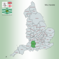
| Location |
| ||||
| |||||

Ceremonial counties of England: Bedfordshire · Berkshire · Buckinghamshire · Cambridgeshire · Cheshire · Cornwall · Cumbria · Derbyshire · Devon · Dorset · County Durham · East Riding of Yorkshire · East Sussex · Essex · Gloucestershire · London · Greater Manchester · Hampshire · Herefordshire · Hertfordshire · Isle of Wight · Kent · Lancashire · Leicestershire · Lincolnshire · Merseyside · Norfolk, England · North Yorkshire · Northamptonshire · Northumberland · Nottinghamshire · Oxfordshire · Rutland · Shropshire · Somerset · South Yorkshire · Staffordshire · Suffolk · Surrey · Tyne and Wear · Warwickshire · West Midlands (county) · West Sussex · West Yorkshire · Wiltshire · Worcestershire
City-counties: Bristol · City of London
Former historic counties: Cumberland · Huntingdonshire · County of London · Middlesex · North Riding of Yorkshire · Sussex · West Riding of Yorkshire · Westmorland · Yorkshire
Other former counties: Avon · Cambridgeshire and Isle of Ely · Cleveland · East Suffolk · Hereford and Worcester · Hexhamshire · Humberside · Huntingdon and Peterborough · Isle of Ely · Parts of Holland · Parts of Kesteven · Parts of Lindsey · Soke of Peterborough · West Suffolk

Subcategories
This category has the following 10 subcategories, out of 10 total.
C
H
M
S
W
Y
Media in category "Historic counties of England"
The following 40 files are in this category, out of 40 total.
-
 -ham and -ingham place names.png 1,632 × 2,016; 298 KB
-
 Dorset Map.png 4,967 × 4,967; 4.21 MB
-
 Gloucestershire Map.png 4,967 × 4,967; 4.21 MB
-
 Hampshire Map.png 4,967 × 4,967; 4.27 MB
-
 Herefordshire Map.png 4,967 × 4,967; 4.27 MB
-
 Hertfordshire Map.png 4,967 × 4,967; 4.29 MB
-
 Huntingdonshire Map.png 4,967 × 4,967; 4.29 MB
-
 Kent Map.png 4,967 × 4,967; 4.26 MB
-
 Lancashire Map.png 4,967 × 4,967; 4.32 MB
-
 Leicestershire County Map.png 4,967 × 4,967; 4.25 MB
-
 Lincolnshire Map.png 4,967 × 4,967; 4.19 MB
-
 Map showing the traditional, geographical counties of England.png 4,967 × 4,967; 4.45 MB
-
 Map showing the traditional, geographical county of Bedfordshire, England.png 4,967 × 4,967; 4.27 MB
-
 Map showing the traditional, geographical county of Berkshire, England.png 4,967 × 4,967; 4.35 MB
-
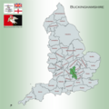 Map showing the traditional, geographical county of Buckinghamshire, England.png 4,967 × 4,967; 4.39 MB
-
 Map showing the traditional, geographical county of Cambridgeshire, England.png 4,967 × 4,967; 4.28 MB
-
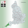 Map showing the traditional, geographical county of Cornwall Kernow, England.png 4,967 × 4,967; 4.19 MB
-
 Map showing the traditional, geographical county of County Durham, England.png 4,967 × 4,967; 4.23 MB
-
 Map showing the traditional, geographical county of Cumberland, England.png 4,967 × 4,967; 4.31 MB
-
 Map showing the traditional, geographical county of Devon, England.png 4,967 × 4,967; 4.2 MB
-
 Map showing the traditional, geographical county of Essex, England.png 4,967 × 4,967; 4.34 MB
-
 Middlesex Map.png 4,967 × 4,967; 4.28 MB
-
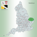 Norfolk Map.png 4,967 × 4,967; 4.22 MB
-
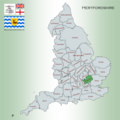
 Northamptonshire Map.png 4,967 × 4,967; 4.23 MB
-
 Northumberland Map.png 4,967 × 4,967; 4.18 MB
-
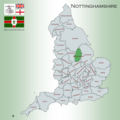 Nottinghamshire Map.png 4,967 × 4,967; 4.22 MB
-
 Oxfordshire Map.png 4,967 × 4,967; 4.34 MB
-
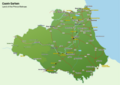 Places of Interest in County Durham.png 4,960 × 3,507; 1.95 MB
-
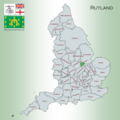 Rutland Map.png 4,967 × 4,967; 4.34 MB
-
 Shropshire Map.png 4,967 × 4,967; 4.38 MB
-
 Somerset Map.png 4,967 × 4,967; 4.37 MB
-
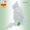
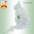 Staffordshire Map.png 4,967 × 4,967; 4.27 MB
-
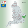 Suffolk Map.png 4,967 × 4,967; 4.31 MB
-
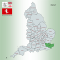
 Surrey Map.png 4,967 × 4,967; 4.21 MB
-
 Sussex Map.png 4,967 × 4,967; 4.3 MB
-
 Warwickshire Map.png 4,967 × 4,967; 4.26 MB
-
 Westmorland Map.png 4,967 × 4,967; 4.52 MB
-
 Wiltshire Map.png 4,967 × 4,967; 4.27 MB
-
 Worcestershire Map.png 4,967 × 4,967; 4.25 MB
-
 Yorkshire Map.png 4,967 × 4,967; 4.38 MB


