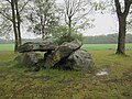
Category:Hunebed D29 in Buinen
dolmen in the Netherlands  | |||||
| Upload media | |||||
| Instance of | |||||
|---|---|---|---|---|---|
| Part of | |||||
| Location |
| ||||
| Located on street |
| ||||
 | |||||
|
This is a category about rijksmonument number 464166
|
| Address |
|
Media in category "Hunebed D29 in Buinen"
The following 4 files are in this category, out of 4 total.
-
 Hunebed D29 Goedeljee.jpg 2,000 × 1,535; 570 KB
-
 Hunebed D29 tussen Borger en Buinen.jpg 1,296 × 972; 300 KB
-
 Hunebed D29.jpg 4,000 × 3,000; 3.23 MB
-
 HunebedD29.jpg 6,000 × 4,000; 11.79 MB


