Category:July 2018 in the East Riding of Yorkshire
Ceremonial counties of England: Bedfordshire · Berkshire · Cambridgeshire · Cheshire · Cornwall · Cumbria · Derbyshire · Devon · Dorset · Durham · East Riding of Yorkshire · East Sussex · Essex · Gloucestershire · Greater London · Greater Manchester · Hampshire · Herefordshire · Hertfordshire · Isle of Wight · Kent · Lancashire · Leicestershire · Lincolnshire · Merseyside · Norfolk · North Yorkshire · Northumberland · Nottinghamshire · Oxfordshire · Shropshire · Somerset · South Yorkshire · Staffordshire · Suffolk · Surrey · Tyne and Wear · Warwickshire · West Midlands · West Sussex · West Yorkshire · Wiltshire · Worcestershire
City-counties: Bristol ·
Former historic counties:
Other former counties:
City-counties: Bristol ·
Former historic counties:
Other former counties:
Deutsch: Bilder, die im Juli 2018 in the East Riding of Yorkshire aufgenommen worden sind. Bitte beachten Sie, dass dies weder das Datum des Uploads noch das Datum des Scannens eines Fotos ist.
English: Images/pictures taken in the East Riding of Yorkshire during July 2018. Note this is not the date of the upload, nor the date a photo was scanned.
Español: Fotografías o imágenes tomadas en the East Riding of Yorkshire durante julio 2018. No es la fecha de subida ni escaneo, sino la fecha en que las fotografías o imágenes se crearon.
Esperanto: Bildoj faritaj en the East Riding of Yorkshire en julio 2018. Tio ne estas la dato, kiam la bildoj estis alŝutitaj aŭ skanitaj.
Français : Photographies ou images prises en the East Riding of Yorkshire durant juillet 2018. Ce n'est pas la date du téléchargement ou du scan.
Galego: Fotografías ou imaxes tomadas en the East Riding of Yorkshire durante xullo 2018. Non é a data de subida nin escaneamento, senón a data na que se crearon as fotografías ou imaxes.
Italiano: Fotografie o immagini scattate a the East Riding of Yorkshire nel luglio 2018. Nota bene: la data non si riferisce né a quella di upload né a quella in cui la foto è stata digitalizzata.
Norsk bokmål: Bilder tatt i the East Riding of Yorkshire i løpet av juli 2018. Merk at dette ikke er datoen for opplasting, eller når et bilde har blitt skannet.
Norsk nynorsk: Bilete teke i the East Riding of Yorkshire i løpet av juli 2018. Merk at dette ikkje er datoen for opplasting, eller når eit bilete har vorte skanna.
Русский: Изображения, сделанные в the East Riding of Yorkshire в течение июль 2018 (не дата загрузки изображения).
Українська: Зображення, зроблені в the East Riding of Yorkshire протягом липень 2018. Зауважте, що це не дата завантаження чи дата сканування фотографії.
| July 2017 | ← | July 2018 | → | July 2019 | |||||||
| Jan | Feb | Mar | Apr | May | Jun | Jul | Aug | Sep | Oct | Nov | Dec |
| 95 | 47 | 36 | 62 | 47 | 47 | 38 | 24 | 42 | 100 | 23 | 51 |
|---|---|---|---|---|---|---|---|---|---|---|---|
Subcategories
This category has only the following subcategory.
Media in category "July 2018 in the East Riding of Yorkshire"
The following 37 files are in this category, out of 37 total.
-
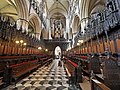 Beveley Minster - East Riding of Yorkshire.jpg 4,592 × 3,448; 12.76 MB
-
 Bridleway through the hedge, near Wetwang (geograph 5829590).jpg 875 × 1,024; 772 KB
-
 Bubwith Rail Trail going through the former Holme Moor station (geograph 5975308).jpg 4,608 × 3,456; 5.36 MB
-
 Butterfly near Elmswell, E Yorks - geograph.org.uk - 5831369.jpg 765 × 1,024; 567 KB
-
 Chinese takeaway on Quay Road, Bridlington (geograph 5831038).jpg 896 × 1,024; 223 KB
-
 Farmland near Wetwang (geograph 5830345).jpg 1,024 × 750; 664 KB
-
 Fields between Wetwang and Garton (geograph 5829958).jpg 1,024 × 756; 810 KB
-
 Fields near Wetwang Grange (geograph 5830356).jpg 1,024 × 683; 812 KB
-
 Grain store at New York Farm - geograph.org.uk - 5832305.jpg 1,024 × 768; 111 KB
-
 Green Lane near Wetwang (geograph 5830522).jpg 1,024 × 683; 865 KB
-
 Green Lane south of Elmswell, E Yorks - geograph.org.uk - 5831370.jpg 683 × 1,024; 858 KB
-
 Growing grain, near Tibthorpe (geograph 5829468).jpg 1,024 × 683; 758 KB
-
 Hand Car Wash on Quay Road, Bridlington (geograph 5830053).jpg 1,024 × 679; 118 KB
-
 Hardware store on Quay Road, Bridlington (geograph 5830021).jpg 961 × 1,024; 240 KB
-
 Houses on St Johns Street, Bridlington (geograph 5845849).jpg 1,024 × 763; 213 KB
-
 Looking into it (geograph 5849127).jpg 4,290 × 3,049; 1.9 MB
-
 Motor factors on St Johns Street, Bridlington (geograph 5840917).jpg 1,024 × 735; 204 KB
-

-
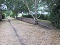 Platform at former railway station (geograph 5975325).jpg 4,608 × 3,456; 4.76 MB
-
 Post Office and shop on Quay Road, Bridlington (geograph 5830057).jpg 1,024 × 686; 149 KB
-
 Potatoes near Garton Field (geograph 5829993).jpg 1,024 × 683; 872 KB
-
 Quay Road, Bridlington (geograph 5830064).jpg 1,024 × 768; 138 KB
-
 Shops on Quay Road, Bridlington (geograph 5830062).jpg 1,024 × 880; 201 KB
-
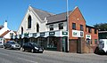
 Shops on Quay Road, Bridlington (geograph 5831014).jpg 1,024 × 768; 183 KB
-
 Shops on Quay Road, Bridlington (geograph 5831044).jpg 1,024 × 822; 205 KB
-
 Shops on St Johns Street, Bridlington (geograph 5845502).jpg 1,024 × 810; 251 KB
-
 Telephone kiosk on Quay Road, Bridlington (geograph 5830046).jpg 1,024 × 768; 226 KB
-
 The Hollies, Willerby (geograph 5864596).jpg 1,024 × 768; 866 KB
-
 Vanessa cardui (geograph 5830000).jpg 1,024 × 810; 781 KB
-
 War memorial and cottages in Warter. (geograph 5848407).jpg 1,024 × 683; 195 KB
-
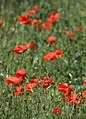 Wayside poppies, north of Tibthorpe (geograph 5831375).jpg 739 × 1,024; 745 KB
-
 Welton Church and Pond (geograph 5849133).jpg 4,356 × 3,355; 2.54 MB
-
 West Building Supplies, Bridlington (geograph 5845456).jpg 1,024 × 606; 179 KB
-
 Wheat field north of Tibthorpe (geograph 5829504).jpg 683 × 1,024; 800 KB
-
 Wheatfield near Greenland Farm (geograph 5856090).jpg 1,024 × 768; 110 KB
-
 Wilberfoss, East Yorkshire, St John the Baptist (geograph 5920488).jpg 4,608 × 3,456; 3.98 MB
-
 Zygaena filipendulae (Six-spot burnet moth).jpg 3,412 × 2,275; 2.63 MB

.jpg)
.jpg)

.jpg)
.jpg)
.jpg)
.jpg)

.jpg)

.jpg)
.jpg)
.jpg)
.jpg)
.jpg)
.jpg)
.jpg)
.jpg)
.jpg)
.jpg)
.jpg)
.jpg)
.jpg)
.jpg)
.jpg)
.jpg)
.jpg)
.jpg)
.jpg)
.jpg)
.jpg)
.jpg)
.jpg)
.jpg)
.jpg)
.jpg)