Category:Maps of Bedford County, Pennsylvania
Counties of Pennsylvania : Adams · Allegheny · Armstrong · Beaver · Bedford · Berks · Blair · Bradford · Bucks · Butler · Cambria · Cameron · Carbon · Centre · Chester · Clarion · Clearfield · Clinton · Columbia · Crawford · Cumberland · Dauphin · Delaware · Elk · Erie · Fayette · Forest · Franklin · Fulton · Greene · Huntingdon · Indiana · Jefferson · Juniata · Lackawanna · Lancaster · Lawrence · Lebanon · Lehigh · Luzerne · Lycoming · McKean · Mercer · Mifflin · Monroe · Montgomery · Montour · Northampton · Northumberland · Perry · Philadelphia · Pike · Potter · Schuylkill · Snyder · Somerset · Sullivan · Susquehanna · Tioga · Union · Venango · Warren · Washington · Wayne · Westmoreland · Wyoming · York
Wikimedia category | |||||
| Upload media | |||||
| Instance of | |||||
|---|---|---|---|---|---|
| Category combines topics | |||||
| Bedford County | |||||
county in Pennsylvania, United States   | |||||
| Instance of | |||||
| Named after | |||||
| Location | Pennsylvania | ||||
| Capital | |||||
| Inception |
| ||||
| Population |
| ||||
| Area |
| ||||
| Different from | |||||
| official website | |||||
 | |||||
Bedford County is located in Pennsylvania in the United States. Its county seat is Bedford.
Subcategories
This category has only the following subcategory.
.
Media in category "Maps of Bedford County, Pennsylvania"
The following 56 files are in this category, out of 56 total.
-

-

-

-

-

-

-

-

-
-
-

-
 Buchanan state park.png 1,024 × 784; 340 KB
-
 Map of Bedford County Pennsylvania School Districts.png 356 × 440; 14 KB
-

-
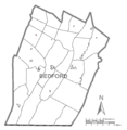
 Map of Bedford County, Pennsylvania No Text.png 1,764 × 1,816; 67 KB
-
 Map of Bedford County, Pennsylvania.png 1,764 × 1,816; 177 KB
-
 Map of Bedford Township, Bedford County, Pennsylvania Highlighted.png 1,764 × 1,816; 68 KB
-
 Map of Bedford, Bedford County, Pennsylvania Highlighted.png 1,764 × 1,816; 67 KB
-
 Map of Bloomfield Township, Bedford County, Pennsylvania Highlighted.png 1,764 × 1,816; 67 KB
-
 Map of Broad Top Township, Bedford County, Pennsylvania Highlighted.png 1,764 × 1,816; 68 KB
-
 Map of Coaldale, Bedford County, Pennsylvania Highlighted.png 1,764 × 1,816; 67 KB
-
 Map of Colerain Township, Bedford County, Pennsylvania Highlighted.png 1,764 × 1,816; 68 KB
-
 Map of Cumberland Valley Township, Bedford County, Pennsylvania Highlighted.png 1,764 × 1,816; 68 KB
-
 Map of East Providence Township, Bedford County, Pennsylvania Highlighted.png 1,764 × 1,816; 67 KB
-
 Map of East St. Clair Township, Bedford County, Pennsylvania Highlighted.png 1,764 × 1,816; 67 KB
-
 Map of Everett, Bedford County, Pennsylvania Highlighted.png 1,764 × 1,816; 67 KB
-
 Map of Harrison Township, Bedford County, Pennsylvania Highlighted.png 1,764 × 1,816; 68 KB
-
 Map of Hopewell Township, Bedford County, Pennsylvania Highlighted.png 1,764 × 1,816; 67 KB
-
 Map of Hopewell, Bedford County, Pennsylvania Highlighted.png 1,764 × 1,816; 67 KB
-
 Map of Hyndman, Bedford County, Pennsylvania Highlighted.png 1,764 × 1,816; 67 KB
-
 Map of Juniata Township, Bedford County, Pennsylvania Highlighted.png 1,764 × 1,816; 67 KB
-
 Map of Kimmel Township, Bedford County, Pennsylvania Highlighted.png 1,764 × 1,816; 67 KB
-
 Map of King Township, Bedford County, Pennsylvania Highlighted.png 1,764 × 1,816; 67 KB
-
 Map of Liberty Township, Bedford County, Pennsylvania Highlighted.png 1,764 × 1,816; 67 KB
-
 Map of Lincoln Township, Bedford County, Pennsylvania Highlighted.png 1,764 × 1,816; 67 KB
-
 Map of Londonderry Township, Bedford County, Pennsylvania Highlighted.png 1,764 × 1,816; 68 KB
-
 Map of Mann Township, Bedford County, Pennsylvania Highlighted.png 1,764 × 1,816; 67 KB
-
 Map of Manns Choice, Bedford County, Pennsylvania Highlighted.png 1,764 × 1,816; 67 KB
-
 Map of Monroe Township, Bedford County, Pennsylvania Highlighted.png 1,764 × 1,816; 67 KB
-
 Map of Napier Township, Bedford County, Pennsylvania Highlighted.png 1,764 × 1,816; 68 KB
-
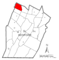
 Map of New Paris, Bedford County, Pennsylvania Highlighted.png 1,764 × 1,816; 67 KB
-
 Map of Pavia Township, Bedford County, Pennsylvania Highlighted.png 1,764 × 1,816; 67 KB
-
 Map of Pennsylvania highlighting Bedford County.svg 4,950 × 2,846; 106 KB
-
 Map of Pleasantville, Bedford County, Pennsylvania Highlighted.png 1,764 × 1,816; 67 KB
-
 Map of Rainsburg, Bedford County, Pennsylvania Highlighted.png 1,764 × 1,816; 67 KB
-
 Map of Saxton, Bedford County, Pennsylvania Highlighted.png 1,764 × 1,816; 67 KB
-
 Map of Schellsburg, Bedford County, Pennsylvania Highlighted.png 1,764 × 1,816; 67 KB
-
 Map of Snake Spring Township, Bedford County, Pennsylvania Highlighted.png 1,764 × 1,816; 67 KB
-
 Map of South Woodbury Township, Bedford County, Pennsylvania Highlighted.png 1,764 × 1,816; 67 KB
-
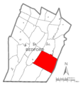
 Map of Southampton Township, Bedford County, Pennsylvania Highlighted.png 1,764 × 1,816; 67 KB
-
 Map of St. Clairsville, Bedford County, Pennsylvania Highlighted.png 1,764 × 1,816; 67 KB
-
 Map of West Providence Township, Bedford County, Pennsylvania Highlighted.png 1,764 × 1,816; 68 KB
-
 Map of West St. Clair Township, Bedford County, Pennsylvania Highlighted.png 1,764 × 1,816; 67 KB
-
 Map of Woodbury Township, Bedford County, Pennsylvania Highlighted.png 1,764 × 1,816; 67 KB
-
 Map of Woodbury, Bedford County, Pennsylvania Highlighted.png 1,764 × 1,816; 67 KB
-
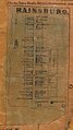 Rainsburg in 1861.jpg 540 × 961; 147 KB


