Category:Maps of Northampton County, Pennsylvania
Counties of Pennsylvania : Adams · Allegheny · Armstrong · Beaver · Bedford · Berks · Blair · Bradford · Bucks · Butler · Cambria · Cameron · Carbon · Centre · Chester · Clarion · Clearfield · Clinton · Columbia · Crawford · Cumberland · Dauphin · Delaware · Elk · Erie · Fayette · Forest · Franklin · Fulton · Greene · Huntingdon · Indiana · Jefferson · Juniata · Lackawanna · Lancaster · Lawrence · Lebanon · Lehigh · Luzerne · Lycoming · McKean · Mercer · Mifflin · Monroe · Montgomery · Montour · Northampton · Northumberland · Perry · Philadelphia · Pike · Potter · Schuylkill · Snyder · Somerset · Sullivan · Susquehanna · Tioga · Union · Venango · Warren · Washington · Wayne · Westmoreland · Wyoming · York
Wikimedia category | |||||
| Upload media | |||||
| Instance of | |||||
|---|---|---|---|---|---|
| Category combines topics | |||||
| Northampton County | |||||
county in Pennsylvania, United States    | |||||
| Instance of |
| ||||
| Named after | |||||
| Location | Pennsylvania | ||||
| Capital | |||||
| Inception |
| ||||
| Population |
| ||||
| Area |
| ||||
| Different from | |||||
| official website | |||||
 | |||||
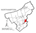
Northampton County is located in southeast Pennsylvania in the United States. Its county seat is Easton.
Subcategories
This category has the following 4 subcategories, out of 4 total.
.
Pages in category "Maps of Northampton County, Pennsylvania"
This category contains only the following page.
Media in category "Maps of Northampton County, Pennsylvania"
The following 22 files are in this category, out of 22 total.
-

-
 Area View around Catasauqua Creek and the Crane Iron Works in 2017-USGS.png 855 × 633; 1.28 MB
-

-

-
 Easton Location.png 1,425 × 1,308; 36 KB
-
 Easton-Glendon.png 1,425 × 1,308; 36 KB
-
 Easton-West Easton.png 1,425 × 1,308; 37 KB
-
 Glendon-West Easton-Wilson.png 1,425 × 1,308; 38 KB
-
 Greater Easton.png 1,425 × 1,308; 39 KB
-
 Lehigh-Canal-Lower-Grand.png 800 × 600; 308 KB
-
 Lehighrivermap.png 300 × 300; 22 KB
-
 Map of Northampton County Pennsylvania School Districts.png 333 × 309; 11 KB
-

-
 Map of Northampton County, Pennsylvania No Text.png 1,425 × 1,308; 50 KB
-
 Map of Northampton County, Pennsylvania.png 1,425 × 1,308; 179 KB
-
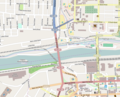 OSM Hill to Hill Bridge in 2014.tiff 837 × 679; 414 KB
-
 Pa2025map.svg 700 × 674; 81 KB
-
 Sr2025map.png 700 × 657; 130 KB
-
 Stockertown map.png 2,996 × 2,352; 1.27 MB
-
 Stockertown map.svg 2,809 × 2,205; 2.31 MB
-
 Stockertown-map.svg 2,301 × 1,805; 3.07 MB
-
 The Pennsylvania-German Society - (Publications) (1891) (14784789022).jpg 2,880 × 1,632; 694 KB


_(1891)_(14784789022).jpg)