Category:Maps of County Durham
Wikimedia category | |||||
| Upload media | |||||
| Instance of | |||||
|---|---|---|---|---|---|
| Category combines topics | |||||
| County Durham | |||||
ceremonial county in North East England, United Kingdom .jpg)  | |||||
| Instance of |
| ||||
| Named after | |||||
| Location |
| ||||
| Capital | |||||
| Creator | |||||
| Population |
| ||||
| Area |
| ||||
| Different from | |||||
| Said to be the same as | County Durham (historic county of England, ceremonial county of England, 1844) | ||||
 | |||||
Subcategories
This category has the following 8 subcategories, out of 8 total.
C
- County Durham RJD 1914 (1 F)
D
E
- Election maps of County Durham (43 F)
R
W
- Wards of County Durham (12 F)
Media in category "Maps of County Durham"
The following 44 files are in this category, out of 44 total.
-
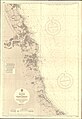 Admiralty Chart No 3104 Blyth to Hartlepool, Published 1963.jpg 11,299 × 16,413; 64.81 MB
-
 Barnard Castle - Durham dot.png 1,802 × 2,589; 189 KB
-
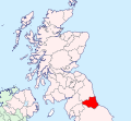
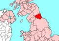
 County Durham UK locator map 2010.svg 1,108 × 1,345; 302 KB
-
 Durham - British Isles.svg 1,250 × 1,835; 1,002 KB
-
 Durham Brit Isles Sect 2.svg 915 × 841; 1,004 KB
-
 Durham Brit Isles Sect 3.svg 939 × 677; 972 KB
-
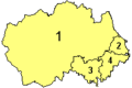 Durham Ceremonial Numbered 2009.png 200 × 133; 2 KB
-
 Durham Ceremonial Numbered.png 200 × 133; 4 KB
-
 Durham Council UK ward map 2010 (blank).svg 1,425 × 934; 1.26 MB
-
 Durham Council UK ward map 2013 (blank).svg 1,425 × 934; 1.19 MB
-
 Durham outline map with UK (2009).png 722 × 478; 270 KB
-
 Durham outline map with UK.png 722 × 478; 310 KB
-
 Durham UK district map (blank).svg 1,425 × 934; 756 KB
-
 Durham UK location map.svg 1,425 × 934; 1.39 MB
-
 Durham UK parish map (blank).svg 1,425 × 934; 1.8 MB
-
 Durham UK relief location map.jpg 1,999 × 1,309; 319 KB
-
 Durham UK ward map (blank).svg 1,425 × 934; 1.41 MB
-
 Durham1950.svg 862 × 661; 1.3 MB
-
 Durham1974.svg 806 × 647; 1.68 MB
-
 DurhamBrit2.PNG 608 × 604; 20 KB
-
 DurhamBrit3.PNG 698 × 491; 19 KB
-
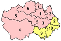
 DurhamNumbered.png 200 × 143; 13 KB
-
 England Police Forces (Durham).svg 1,108 × 1,345; 312 KB
-
 EnglandDurham.svg 200 × 247; 233 KB
-
 EnglandPoliceDurham.png 2,165 × 2,670; 87 KB
-
 Esh Winning, County Durham.svg 1,671 × 1,070; 967 KB
-
 Map of the Teesside Built-up Area.png 1,297 × 850; 1.14 MB
-
 NE-belt.svg 1,713 × 1,996; 2.91 MB
-
 New Brancepeth, County Durham.svg 846 × 623; 493 KB
-
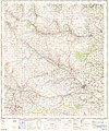
 Ordnance Survey 1-250000 - NY.jpg 4,000 × 4,000; 8.08 MB
-
 Ordnance Survey 1-250000 - NZ.jpg 4,000 × 4,000; 5.22 MB
-
 Ordnance Survey Durham & Sunderland 1" Popular edition 1925 Consett area.jpg 2,400 × 1,700; 3.3 MB
-
 Ordnance Survey One-Inch Sheet 84 Teesdale, Published 1964.jpg 8,230 × 9,875; 11.42 MB
-
 Ordnance Survey One-Inch Sheet 85 Durham, Published 1961.jpg 8,265 × 9,883; 11.36 MB
-
 Ordnance Survey Popular Edition 1" map Darlington sheet 1925 a section.jpg 2,400 × 1,700; 3.04 MB
-
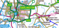 OS map Durham Tees Valley Airport.png 596 × 283; 50 KB
-
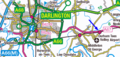 OS map Teesside Airport railway station.png 596 × 283; 50 KB
-
 OS Street View NY94NE.jpg 5,000 × 5,000; 1.3 MB
-
 Tees Valley Combined Authority UK.svg 1,437 × 782; 892 KB
-
 Teesside CB in 1971 within North Riding.png 2,022 × 1,264; 57 KB
-
 TynesideBUA.png 1,618 × 850; 1.43 MB
-
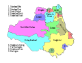
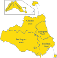
 County Durham Wards.svg 1,000 × 804; 313 KB
-
 County Durham Wards - definition B.svg 970 × 981; 424 KB
-
 Wear-valley07.png 800 × 463; 50 KB


.png)


.svg)


.svg)
.svg)
.svg)
.svg)
.svg)