Category:Maps of Wellington
Wikimedia category | |||||
| Upload media | |||||
| Instance of | |||||
|---|---|---|---|---|---|
| Category combines topics | |||||
| Wellington City | |||||
territorial authority district in New Zealand      | |||||
| Instance of |
| ||||
| Location | Wellington Region, New Zealand | ||||
| Located in or next to body of water | |||||
| Head of government |
| ||||
| Population |
| ||||
| Area |
| ||||
| Elevation above sea level |
| ||||
 | |||||
English: Maps of Wellington City, New Zealand. See Category:Maps of the Wellington Region for the wider Wellington urban area and Wellington Region.
Subcategories
This category has the following 2 subcategories, out of 2 total.
P
Media in category "Maps of Wellington"
The following 20 files are in this category, out of 20 total.
-

-
 1909 Map of Petone and Lower Hutt NZMS013 WN82.jpg 5,075 × 4,876; 21.82 MB
-
-
 EmbassiesInWellington-City.png 465 × 748; 120 KB
-
 Kelburn.png 650 × 870; 247 KB
-
 Location map New Zealand Wellington.png 1,017 × 912; 621 KB
-
 Location of Wellington.png 783 × 965; 102 KB
-
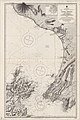
 Map of Evans Bay Patent Slip, Wellington, New Zealand.jpg 5,031 × 7,626; 19.01 MB
-
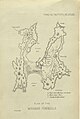 Miramar Peninsula map 1872.jpg 686 × 1,023; 138 KB
-
 Miramar-1959.png 851 × 866; 1.67 MB
-
 New Zealand Company plan of the Town of Wellington, Port Nicholson, 1840 (15975386086).jpg 9,434 × 6,819; 21.01 MB
-
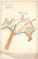
 Township of Seatoun.jpg 7,987 × 10,017; 20.73 MB
-
 Wainuiomata Tunnel map.png 1,590 × 1,346; 504 KB
-
 Wellington CC.PNG 251 × 376; 23 KB
-
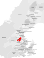
 Wellington City within Wellington Region.png 1,214 × 827; 20 KB
-
 Wellington reclamation animation.gif 451 × 647; 51 KB
-
 Wellington within North Island 2023.png 784 × 918; 101 KB
-
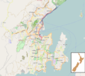
 WellingtonHarbour2022OSM.png 2,735 × 2,667; 5.61 MB
-
 WellingtonNZ.png 490 × 590; 14 KB
-
 WellingtonSuburbsMap.png 1,074 × 1,133; 1.19 MB
%27_(11251022506).jpg)


.jpg)


