Category:Maps of rivers of Finistère
Departments of Metropolitan France: Ain [01] · Aisne [02] · Alpes-de-Haute-Provence [04] · Hautes-Alpes [05] · Ardèche [07] · Ariège [09] · Aube [10] · Aude [11] · Aveyron [12] · Bouches-du-Rhône [13] · Calvados [14] · Cantal [15] · Charente-Maritime [17] · Cher [18] · Corrèze [19] · Corse-du-Sud [2A]† · Haute-Corse [2B]† · Côte-d’Or [21] · Creuse [23] · Drôme [26] · Eure-et-Loir [28] · Finistère [29] · Gard [30] · Haute-Garonne [31] · Gers [32] · Gironde [33] · Hérault [34] · Ille-et-Vilaine [35] · Indre [36] · Indre-et-Loire [37] · Isère [38] · Jura [39] · Landes [40] · Loir-et-Cher [41] · Loire [42] · Haute-Loire [43] · Loire-Atlantique [44] · Loiret [45] · Lot [46] · Lot-et-Garonne [47] · Lozère [48] · Maine-et-Loire [49] · Manche [50] · Marne [51] · Haute-Marne [52] · Mayenne [53] · Meurthe-et-Moselle [54] · Morbihan [56] · Oise [60] · Pas-de-Calais [62] · Puy-de-Dôme [63] · Pyrénées-Atlantiques [64] · Hautes-Pyrénées [65] · Pyrénées-Orientales [66] · Haute-Saône [70] · Saône-et-Loire [71] · Sarthe [72] · Haute-Savoie [74] · Seine-Maritime [76] · Seine-et-Marne [77] · Yvelines [78] · Var [83] · Territoire de Belfort [90] · Val-d'Oise [95]
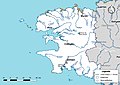
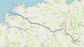
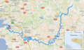
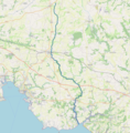
Media in category "Maps of rivers of Finistère"
The following 30 files are in this category, out of 30 total.
-
 29-Cours eau 50km.jpg 3,507 × 2,480; 579 KB
-
 29-Cours eau.jpg 3,507 × 2,480; 1.14 MB
-
 Aber Ildut cours d'eau.png 1,069 × 727; 441 KB
-
 Aber Wrac'h cours d'eau.png 1,182 × 659; 483 KB
-
 Aber-Benoît.png 909 × 599; 375 KB
-
 Aulne.png 682 × 403; 548 KB
-
 Aven cours d'eau.png 1,242 × 1,266; 1.53 MB
-
 Bélon cours d'eau.png 831 × 665; 339 KB
-
 Douffine cours d'eau.png 1,371 × 813; 661 KB
-
 Dourdu cours d'eau.png 633 × 615; 199 KB
-
 Ellez cours d'eau.png 1,116 × 821; 465 KB
-
 Ellé cours d'eau.png 737 × 599; 865 KB
-
 Elorn.png 902 × 486; 769 KB
-
 Frout odet cours d'eau.png 1,252 × 891; 695 KB
-
 Goyen cours d'eau.png 977 × 717; 264 KB
-
 Guic cours d'eau.png 1,499 × 869; 548 KB
-
 Isole cours d'eau.png 1,029 × 1,212; 1.25 MB
-
 Jet cours d'eau.png 1,046 × 815; 552 KB
-
 Laita carte.jpg 2,349 × 2,986; 607 KB
-
 Le Fao carte topo.png 1,307 × 718; 892 KB
-
 Locronan grande tromenie 2019.png 1,920 × 1,080; 1,014 KB
-
 Moros cours d'eau.png 617 × 637; 220 KB
-
 Odet cours d'eau.png 1,209 × 863; 564 KB
-
 Penzé cours d'eau.png 1,171 × 1,281; 1.7 MB
-
 Queffleuth cours d'eau.png 1,060 × 837; 569 KB
-
 Rivière Aven carte.png 2,484 × 3,496; 1.44 MB
-
 Rivière Aven.jpg 2,484 × 3,496; 561 KB
-
 Scorff cours d'eau.png 679 × 631; 356 KB
-
 Ster Goz cours d'eau.png 709 × 648; 252 KB
-
 Steïr.png 350 × 619; 276 KB


