Category:Maps of rivers of Indre
Departments of Metropolitan France: Ain [01] · Aisne [02] · Alpes-de-Haute-Provence [04] · Hautes-Alpes [05] · Ardèche [07] · Ariège [09] · Aube [10] · Aude [11] · Aveyron [12] · Bouches-du-Rhône [13] · Calvados [14] · Cantal [15] · Charente-Maritime [17] · Cher [18] · Corrèze [19] · Corse-du-Sud [2A]† · Haute-Corse [2B]† · Côte-d’Or [21] · Creuse [23] · Drôme [26] · Eure-et-Loir [28] · Finistère [29] · Gard [30] · Haute-Garonne [31] · Gers [32] · Gironde [33] · Hérault [34] · Ille-et-Vilaine [35] · Indre [36] · Indre-et-Loire [37] · Isère [38] · Jura [39] · Landes [40] · Loir-et-Cher [41] · Loire [42] · Haute-Loire [43] · Loire-Atlantique [44] · Loiret [45] · Lot [46] · Lot-et-Garonne [47] · Lozère [48] · Maine-et-Loire [49] · Manche [50] · Marne [51] · Haute-Marne [52] · Mayenne [53] · Meurthe-et-Moselle [54] · Morbihan [56] · Oise [60] · Pas-de-Calais [62] · Puy-de-Dôme [63] · Pyrénées-Atlantiques [64] · Hautes-Pyrénées [65] · Pyrénées-Orientales [66] · Haute-Saône [70] · Saône-et-Loire [71] · Sarthe [72] · Haute-Savoie [74] · Seine-Maritime [76] · Seine-et-Marne [77] · Yvelines [78] · Var [83] · Territoire de Belfort [90] · Val-d'Oise [95]
Media in category "Maps of rivers of Indre"
The following 52 files are in this category, out of 52 total.
-
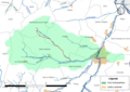
 36-Bassins-versants.jpg 3,507 × 2,480; 443 KB
-
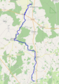
 36-Cours eau 50km.jpg 3,507 × 2,480; 603 KB
-
 36-Cours eau.jpg 3,507 × 2,480; 1.51 MB
-
 36-Hydro-Listes1-2.jpg 3,507 × 2,480; 811 KB
-
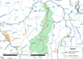
 36-Régions hydro.jpg 3,507 × 2,480; 626 KB
-
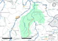
 36-Sous-Bassins adm.jpg 3,507 × 2,480; 543 KB
-
 Brion (rivière) OSM.png 826 × 414; 219 KB
-
 CE-Allemette.png 3,507 × 2,480; 1.66 MB
-
 CE-Aubord.png 3,507 × 2,480; 1.96 MB
-
 CE-Bel Rio.png 3,507 × 2,480; 1.68 MB
-
 CE-Bordelet.png 3,507 × 2,480; 1.7 MB
-
 CE-Bouzantin.png 3,507 × 2,480; 1.48 MB
-
 CE-Brion.png 3,507 × 2,480; 1.55 MB
-
 CE-Cinq Bondes.png 3,507 × 2,480; 2.39 MB
-
 CE-Creuzançais.png 3,507 × 2,480; 1.68 MB
-
 CE-Gourdon.png 3,507 × 2,480; 1.95 MB
-
 CE-Les Palles.png 3,507 × 2,480; 1.3 MB
-
 CE-Malville.png 3,507 × 2,480; 1.62 MB
-
 CE-Modon.png 3,507 × 2,480; 2 MB
-
 CE-Mortaigue.png 3,507 × 2,480; 1.33 MB
-
 CE-Ozance.png 3,507 × 2,480; 1.35 MB
-
 CE-Petite Thonaise.png 3,507 × 2,480; 1.78 MB
-
 CE-Petite Tournemine.png 3,507 × 2,480; 1.33 MB
-
 CE-Poinsonnet.png 3,507 × 2,480; 1.64 MB
-
 CE-Poulain.png 3,507 × 2,480; 1.7 MB
-
 CE-Suin.png 3,507 × 2,480; 2.24 MB
-
 CE-Traine Feuilles.png 3,507 × 2,480; 2 MB
-
 CE-Trégonce.png 3,507 × 2,480; 1.8 MB
-
 CE-Vavret.png 3,507 × 2,480; 1.67 MB
-
 Céphons.png 494 × 459; 105 KB
-
 Gourdon (rivière).png 502 × 763; 247 KB
-
 Liennet.png 430 × 612; 217 KB
-
 ME-FRGR0340a-Petite-Tournemine.png 3,507 × 2,480; 2.95 MB
-
 ME-FRGR0340b-Mortaigue.png 3,507 × 2,480; 1.32 MB
-
 ME-FRGR0346-Bordelet.png 3,507 × 2,480; 2.3 MB
-
 ME-FRGR0346-Poulain.png 3,507 × 2,480; 2.31 MB
-
 ME-FRGR0348-Modon.png 3,507 × 2,480; 1.97 MB
-
 ME-FRGR0348-Traine Feuille.png 3,507 × 2,480; 1.98 MB
-
 ME-FRGR0413-Bel Rio.png 3,507 × 2,480; 2.09 MB
-
 ME-FRGR0428b-Cinq Bondes.png 3,507 × 2,480; 1.87 MB
-
 ME-FRGR1845-Bouzantin.png 3,507 × 2,480; 831 KB
-
 ME-FRGR1852-Les Palles.png 3,507 × 2,480; 1.3 MB
-
 ME-FRGR1869-Allemette.png 3,507 × 2,480; 1.62 MB
-
 ME-FRGR1869-Vavret.png 3,507 × 2,480; 1.66 MB
-
 ME-FRGR1904-Brion.png 3,507 × 2,480; 1.18 MB
-
 ME-FRGR1916-Creuzançais.png 3,507 × 2,480; 1.66 MB
-
 ME-FRGR1926-Aubord.png 3,507 × 2,480; 1.94 MB
-
 ME-FRGR1926-Gourdon.png 3,507 × 2,480; 1.93 MB
-
 ME-FRGR2032-Ozance.png 3,507 × 2,480; 1.19 MB
-
 ME-FRGR2037-Trégonce.png 3,507 × 2,480; 1.36 MB
-
 ME-FRGR2059-Malville.png 3,507 × 2,480; 990 KB
-
 Vignole (affluent de la Théols) OSM.png 1,299 × 690; 436 KB


_OSM.png)


.png)


_OSM.png)