Category:Maps of the history of Oceania
Temperate regions: North America · South America · Africa · Europe · Asia · Oceania – Polar regions: – Other regions:
| NO WIKIDATA ID FOUND! Search for Maps of the history of Oceania on Wikidata | |
| Upload media |
Use the appropriate category for maps showing all or a large part of Oceania. See subcategories for smaller areas:
| If the map shows | Category to use |
|---|---|
| Oceania on a recently created map | Category:Maps of Oceania or its subcategories |
| Oceania on a map created more than 70 years ago | Category:Old maps of Oceania or its subcategories |
| the history of Oceania on a recently created map | Category:Maps of the history of Oceania or its subcategories |
| the history of Oceania on a map created more than 70 years ago | Category:Old maps of the history of Oceania or its subcategories |

Subcategories
This category has the following 12 subcategories, out of 12 total.
Media in category "Maps of the history of Oceania"
The following 33 files are in this category, out of 33 total.
-
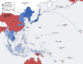
 Second world war asia 1943-1945 map de.png 1,298 × 998; 193 KB
-
 Second world war asia 1943-1945 map pl2.png 1,300 × 1,000; 214 KB
-
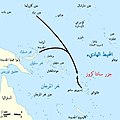 Battle of Santa Cruz map-ar.jpg 800 × 799; 105 KB
-
 Battle of Santa Cruz map-fr.svg 1,345 × 1,343; 146 KB
-
 Cookroutes.png 643 × 430; 113 KB
-
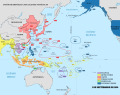
 East Asia and Oceania 1914 german.png 2,008 × 1,546; 463 KB
-
 East Asia and Oceania 1914-de.svg 2,613 × 2,013; 1.15 MB
-
 East Asia and Oceania 1914-en.svg 2,613 × 2,013; 1.15 MB
-
 East Asia and Oceania 1914-fr.svg 2,613 × 2,013; 1.15 MB
-
 East Asia and Oceania 1914-no text.svg 2,613 × 2,013; 1.16 MB
-
 Eastern Hemisphere 1300 BC.png 3,240 × 1,903; 8.1 MB
-
 Kolonialmächte im Pazifikraum, 1939.svg 1,039 × 814; 1.76 MB
-
 Le Maire en Schouten - Reis via Kaap Hoorn naar Indie 1615-1616.png 1,021 × 474; 60 KB
-
 Miklouho-Maclay's travels - ru.png 1,500 × 1,254; 3.08 MB
-
 Miklouho-Maclay's travels-ru.svg 1,500 × 1,254; 4.6 MB
-
 Oceania politic 1914.png 2,000 × 1,300; 265 KB
-
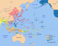
 Pacific Area - Imperial Powers 1939 - Map.svg 1,039 × 814; 4.44 MB
-
 Pacific Area - The Imperial Powers 1939 - Map - ru.svg 1,039 × 814; 4.47 MB
-
 Pacific Area - The Imperial Powers 1939 - Map mk.svg 1,039 × 814; 4.43 MB
-
 Pacific Area - The Imperial Powers 1939 - Map-es.svg 1,039 × 814; 2.89 MB
-
 Pacific Area - The Imperial Powers 1939 - Map-hu.svg 1,039 × 814; 4.47 MB
-
 Pacific Area - The Imperial Powers 1939 - Map-it.svg 1,039 × 814; 2.25 MB
-
 Pacific Area - The Imperial Powers 1939 - Map-zh.svg 1,039 × 814; 4.44 MB
-
 Pacific Area - The Imperial Powers 1939 - Map.jpg 1,202 × 917; 615 KB
-
 Pacific Area - The Imperial Powers 1939 - Map.svg 1,039 × 814; 4.49 MB
-
 Pacific Assembly Programme.jpg 3,637 × 2,727; 2.77 MB
-
 Second world war asia 1937-1942 map blank.svg 1,300 × 1,000; 173 KB
-
 Second world war asia 1937-1942 map pl.png 1,300 × 1,000; 390 KB
-
 Second world war asia 1937-1942 map pl2.png 1,300 × 1,000; 206 KB
-
 Second world war asia 1943-1945 map pl.png 1,300 × 1,000; 398 KB
-
 South Pacific Mandate map in 1930s.PNG 1,751 × 1,071; 895 KB
-
 Trajets des navigateurs français en Océanie au XVIIIe - début XIXe siècles.png 3,316 × 2,800; 921 KB
-
 Wallis, Futuna, Samoa, Tonga, Niue, Fidji (Polynésie ancestrale) Fr.svg 1,429 × 846; 88 KB


_Fr.svg)