Category:Maps showing 2016
| ← 2010 2011 2012 2013 2014 2015 2016 2017 2018 2019→ |
English: Maps showing the year 2016 (i.e. history maps)
See also category: 2016 maps. and 2010s maps for old maps created in this time.
See also category: 2016 maps. and 2010s maps for old maps created in this time.
Subcategories
This category has the following 3 subcategories, out of 3 total.
E
- ECHO Daily Maps of 2016 (251 F)
- ECHO Situation Maps of 2016 (40 F)
U
Media in category "Maps showing 2016"
The following 4 files are in this category, out of 4 total.
-
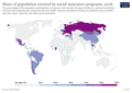 Coverage-of-social-insurance-programs.png 3,400 × 2,400; 761 KB
-
 Flag Map of The World (2016).png 4,974 × 2,519; 751 KB
-
 Location map Washington, D.C. central.png 627 × 599; 218 KB
-
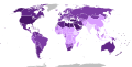 World map of countries by obesity rate (2016).svg 512 × 260; 807 KB

.png)

.svg)