Category:Old Dutch House, Sandwich, Kent
| Object location | | View all coordinates using: OpenStreetMap |
|---|
building in Sandwich, Kent  | |||||
| Upload media | |||||
| Instance of | |||||
|---|---|---|---|---|---|
| Location | Sandwich, Dover, Kent, South East England, England | ||||
| Heritage designation |
| ||||
 | |||||
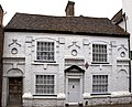
This is a category about listed building number 1105688. |
Media in category "Old Dutch House, Sandwich, Kent"
The following 3 files are in this category, out of 3 total.
-
 Old Dutch House (4907171178).jpg 5,169 × 4,173; 11.86 MB
-

-
 The Old Dutch House. Sandwich Dover.jpg 1,760 × 1,320; 544 KB
.jpg)
