Category:Old maps of Acre (city)
Historical maps of Acre city | |||||
| Upload media | |||||
| Instance of | |||||
|---|---|---|---|---|---|
| |||||
Subcategories
This category has only the following subcategory.
O
- Old maps of Old City of Acre (15 F)
Media in category "Old maps of Acre (city)"
The following 16 files are in this category, out of 16 total.
-

-
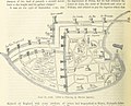 394 of '(British Battles on Land and Sea.)' (11169743055).jpg 1,938 × 1,571; 753 KB
-
 559 of '(Jerusalem, the City of Herod and Saladin.)' (11288220476).jpg 1,568 × 1,120; 439 KB
-

-

-
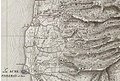 AcreNE1799.jpg 1,065 × 721; 291 KB
-

-
 Chaifa.jpg 750 × 1,000; 173 KB
-
 D095-Plaine d’Esdraelon.-L2-Ch5.png 1,522 × 1,596; 536 KB
-
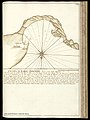
 Environs de Ptolémaïs ou d'Acre pour l'Histoire de Saladin. par le Sr d'Anville.jpg 2,152 × 2,018; 880 KB
-

-

-
 Jerusalem, the city of Herod and Saladin (1889) (14775347644).jpg 2,080 × 1,488; 347 KB
-
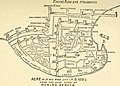
 Karl Baedeker. Akka & Umgebung (1910) (14766736185).jpg 1,245 × 1,279; 408 KB
-

-
 Plan de St. Jean d'Acre indiquant la position de l'armée. 1799.jpg 6,918 × 4,707; 4.03 MB

%27_(11169743055).jpg)
%27_(11288220476).jpg)


_(14775347644).jpg)
_(14766736185).jpg)
.jpg)
