Category:Old maps of Baltimore
Subcategories
This category has the following 2 subcategories, out of 2 total.
Media in category "Old maps of Baltimore"
The following 118 files are in this category, out of 118 total.
-
 (Ville, port, et rade de Baltimore dans le Maryland. LOC gm71000978.jpg 4,568 × 3,476; 1.86 MB
-
 (Ville, port, et rade de Baltimore dans le Maryland. LOC gm71000978.tif 4,568 × 3,476; 45.43 MB
-
-
 Plat of Joppa in 1725.png 740 × 1,454; 271 KB
-
 Plat of Baltimore Town and Jones' Town, 1881.png 1,466 × 1,480; 2.12 MB
-

-
 1855 Colton Plan or Map of Baltimore, Maryland - Geographicus - Baltimore-colton-1855.jpg 4,000 × 3,295; 3.92 MB
-
 1860 Mitchell Map of Baltimore - Geographicus - Baltimore-m-60.jpg 3,445 × 2,906; 2.7 MB
-

-
 1864 Mitchell Map of Baltimore, Maryland - Geographicus - Baltimore-mitchell-1864.jpg 3,458 × 2,964; 2.14 MB
-
 1867 Mitchell Map of Baltimore, Maryland - Geographicus - Baltimore-mitchell-1867.jpg 3,500 × 2,966; 3.41 MB
-

-

-
 1874 Gray Map of Baltimore, Maryland - Geographicus - Baltimore-gray-1874.jpg 3,500 × 2,812; 3.54 MB
-

-
-
-
 Map of the Original Tracts of Land Within The Present Limits of Baltimore, 1881.png 1,662 × 1,532; 727 KB
-

-
 1900 UR&E map.jpg 1,072 × 1,568; 392 KB
-

-

-
 A birds-eye view of the heart of Baltimore. LOC 75694536.jpg 9,968 × 6,560; 12.79 MB
-
 A birds-eye view of the heart of Baltimore. LOC 75694536.tif 9,968 × 6,560; 187.08 MB
-

-
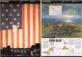
 America's Highways 1776–1976 - page 280.jpg 1,684 × 1,777; 1.92 MB
-
 Baltimore 1873.jpg 8,424 × 5,905; 5.6 MB
-
 Baltimore Street Map, 1838.jpg 2,901 × 2,327; 2.43 MB
-
 Baltimore Street Map, 1860.jpg 2,241 × 1,932; 2.37 MB
-
 Baltimore Street Map, 1867.jpg 2,341 × 2,024; 1.96 MB
-
 Baltimore Street Map, 1873.jpg 3,097 × 2,484; 4.15 MB
-
 Baltimore Street Map, 1883.jpg 2,590 × 3,121; 3.5 MB
-
 Baltimore Street Map, 1892.jpg 3,428 × 2,625; 5.91 MB
-
 Baltimore Street Map, 1894.jpg 3,367 × 2,597; 4.42 MB
-
 Baltimore Street Map, 1895.jpg 2,688 × 3,358; 5.69 MB
-
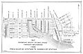
 Calvert St Station Baltimore 1869.png 1,303 × 434; 1.37 MB
-

-

-

-
 EB1911 Maryland and Delaware.jpg 2,621 × 1,843; 2.98 MB
-
 EB9 Baltimore.jpg 786 × 713; 321 KB
-
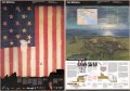
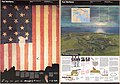
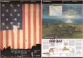
 Fort McHenry National Monument and Historic Shrine, Maryland LOC 00557347.tif 10,080 × 7,060; 203.6 MB
-
 Fort McHenry National Monument and Historic Shrine, Maryland LOC 2002620921.jpg 10,096 × 7,090; 11.93 MB
-
 Fort McHenry National Monument and Historic Shrine, Maryland LOC 2002620921.tif 10,096 × 7,090; 204.79 MB
-
 Fort McHenry National Monument and Historic Shrine, Maryland LOC 2002620936.jpg 10,150 × 7,092; 9.28 MB
-
 Fort McHenry National Monument and Historic Shrine, Maryland LOC 2002620936.tif 10,150 × 7,092; 205.95 MB
-
 Fort McHenry National Monument and Historic Shrine, Maryland LOC 2003623852.jpg 10,120 × 7,064; 9.98 MB
-
 Fort McHenry National Monument and Historic Shrine, Maryland LOC 2003623852.tif 10,120 × 7,064; 204.53 MB
-
 Fort McHenry National Monument and Historic Shrine, Maryland LOC 2005626207.jpg 10,132 × 7,080; 9.99 MB
-
 Fort McHenry National Monument and Historic Shrine, Maryland LOC 2005626207.tif 10,132 × 7,080; 205.23 MB
-
 Fort McHenry National Monument and Historic Shrine, Maryland LOC 2006625696.jpg 10,086 × 7,062; 11.46 MB
-
 Fort McHenry National Monument and Historic Shrine, Maryland LOC 2006625696.tif 10,086 × 7,062; 203.78 MB
-
 Fort McHenry National Monument and Historic Shrine, Maryland LOC 2007630676.jpg 10,148 × 7,098; 11.63 MB
-
 Fort McHenry National Monument and Historic Shrine, Maryland LOC 2007630676.tif 10,148 × 7,098; 206.08 MB
-
 Fort McHenry National Monument and Historic Shrine, Maryland LOC 2010588166.jpg 10,168 × 7,072; 10.83 MB
-
 Fort McHenry National Monument and Historic Shrine, Maryland LOC 2010588166.tif 10,168 × 7,072; 205.73 MB
-
 Fort McHenry National Monument and Historic Shrine, Maryland LOC 2011587877.jpg 10,176 × 7,099; 10.36 MB
-
 Fort McHenry National Monument and Historic Shrine, Maryland LOC 2011587877.tif 10,176 × 7,099; 206.68 MB
-
 Fort McHenry National Monument and Historic Shrine, Maryland LOC 91684469.jpg 10,112 × 7,066; 10.39 MB
-
 Fort McHenry National Monument and Historic Shrine, Maryland LOC 91684469.tif 10,112 × 7,066; 204.42 MB
-
 Fort McHenry National Monument and Historic Shrine, Maryland LOC 93680063.jpg 10,040 × 7,064; 11.98 MB
-
 Fort McHenry National Monument and Historic Shrine, Maryland LOC 93680063.tif 10,040 × 7,064; 202.91 MB
-
 Fort McHenry National Monument and Historic Shrine, Maryland LOC 94684116.jpg 10,080 × 7,062; 11.05 MB
-
 Fort McHenry National Monument and Historic Shrine, Maryland LOC 94684116.tif 10,080 × 7,062; 203.66 MB
-
 Fort McHenry National Monument and Historic Shrine, Maryland LOC 98688137.jpg 10,075 × 7,047; 10.65 MB
-
 Fort McHenry National Monument and Historic Shrine, Maryland LOC 98688137.tif 10,075 × 7,047; 203.13 MB
-
 Fort McHenry National Monument and Historic Shrine, Maryland LOC 99463535.jpg 10,100 × 7,072; 11.54 MB
-
 Fort McHenry National Monument and Historic Shrine, Maryland LOC 99463535.tif 10,100 × 7,072; 204.36 MB
-
 George Brown map.jpg 8,972 × 5,832; 12.52 MB
-
 Improved plan of the city of Baltimore. LOC 77691636.jpg 3,703 × 2,932; 2.11 MB
-
 Improved plan of the city of Baltimore. LOC 77691636.tif 3,703 × 2,932; 31.06 MB
-
 Improved plan of the city of Baltimore. NYPL434628.tiff 4,719 × 3,922; 52.96 MB
-

-
-
 Lucas Baltimore 1852 Cityplan.png 984 × 754; 398 KB
-

-
 Map MD Sidney1850 OldHarfordRd middle LABELEDcrop.GIF 1,373 × 802; 712 KB
-
 Map MD Sidney1850 OldHarfordRd north LABELEDcrop.GIF 1,258 × 718; 560 KB
-
 Map MD Sidney1850 OldHarfordRd south LABELEDcrop.GIF 1,352 × 841; 832 KB
-
 Map of Baltimore and Fort McHenry 1814.jpg 13,787 × 7,264; 9.87 MB
-
 Map of Maryland showing the natural resources of the counties LOC 2009575051.jpg 4,782 × 2,874; 2.21 MB
-
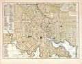
 Map of the central portion of Baltimore City LOC 2002620191.jpg 4,387 × 6,809; 4.6 MB
-
 Map of the central portion of Baltimore City LOC 2002620191.tif 4,387 × 6,809; 85.46 MB
-
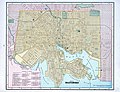
 Map of the city and county of Baltimore, Maryland. LOC 2002624019.jpg 15,804 × 19,291; 55.4 MB
-
 Map of the city and county of Baltimore, Maryland. LOC 2002624020.jpg 10,193 × 13,190; 23.07 MB
-
 Map of the Light Street Bridge.jpg 747 × 1,163; 302 KB
-
 Map of the Washington Baltimore and Annapolis Triangle 1919.jpg 2,063 × 2,339; 1.41 MB
-
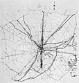
 Map of the Western Maryland Railroad in Baltimore, 1901.png 2,716 × 1,458; 3.92 MB
-
 Meyers b2 s0299 b1.png 389 × 477; 125 KB
-

-
 NIE 1905 Baltimore.jpg 2,160 × 1,683; 1.28 MB
-
 Plan of Baltimore (NYPL b13663520-1510805).tiff 6,298 × 5,246; 94.55 MB
-
 Plan of Baltimore (NYPL b14948186-434944).jpg 4,615 × 3,987; 3.72 MB
-
 Plan of the town of Baltimore and it's (sic) environs (NYPL b14948191-434630).tiff 5,514 × 4,768; 75.24 MB
-
 Baltimore (NYPL b14968672-435004).jpg 4,406 × 4,786; 3.81 MB
-
 Plan of the city of Baltimore LOC 2002624026.jpg 6,923 × 5,374; 7.85 MB
-
 Plan of the city of Baltimore LOC 2002624026.tif 6,923 × 5,374; 106.44 MB
-
 Plan of the city of Baltimore LOC 2002624027.jpg 6,975 × 5,506; 7.92 MB
-
 Plan of the city of Baltimore LOC 2002624027.tif 6,975 × 5,506; 109.88 MB
-
 Plan of the city of Baltimore, Maryland LOC 2004629026.jpg 13,414 × 10,643; 27.75 MB
-
 Plan of the town of Baltimore and it's (sic) environs. LOC 2002624037.jpg 6,248 × 5,574; 5.79 MB
-
 Plan of the town of Baltimore and it's (sic) environs. LOC 2002624037.tif 6,248 × 5,574; 99.64 MB
-
 President St Depot & City Block - Baltimore 1869.jpg 1,396 × 768; 1.67 MB
-
 President St Station Baltimore 1869a.jpg 1,309 × 414; 704 KB
-
 Road from Philadelphia to Washington, seg. 16 NYPL484173.tiff 4,178 × 4,163; 49.77 MB
-
 Situationsplan von Baltimore.jpg 355 × 442; 76 KB
-

-
 This survey of the River Patapsco and part of Chesapeake Bay, LOC 76695381.jpg 11,123 × 9,711; 16.11 MB
-
 This survey of the River Patapsco and part of Chesapeake Bay, LOC 76695381.tif 11,123 × 9,711; 309.03 MB
-
 This survey of the River Patapsco and part of Chesapeake Bay, LOC 76697576.jpg 10,665 × 9,588; 13.95 MB
-
 This survey of the River Patapsco and part of Chesapeake Bay, LOC 76697576.tif 10,665 × 9,588; 292.56 MB
-
 This survey of the River Patapsco and part of Chesapeake Bay, LOC 76697578.jpg 5,802 × 10,121; 7.34 MB
-
 This survey of the River Patapsco and part of Chesapeake Bay, LOC 76697578.tif 5,802 × 10,121; 168.01 MB
-
 This survey of the River Patapsco and part of Chesapeake Bay, LOC 76697579.jpg 10,844 × 9,523; 14.53 MB
-
 This survey of the River Patapsco and part of Chesapeake Bay, LOC 76697579.tif 10,844 × 9,523; 295.45 MB
-

-

-
 United Railways map of Baltimore 1910.jpg 8,495 × 4,670; 14.15 MB

.jpg)


.jpg)


%27_(11063782016).jpg)
%27_(11063640573).jpg)

.jpg)
.jpg)
.jpg)

.jpg)

.jpg)
.jpg)

_(14595080908).jpg)


.jpg)


_(14588136657).jpg)

.jpg)
.jpg)


_environs._LOC_2002624037.jpg)


_(14781708804).jpg)


