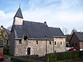
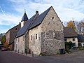
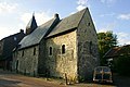
Category:Sint-Catharinakapel (Lemiers)
| Object location | | View all coordinates using: OpenStreetMap |
|---|
chapel in Lemiers, Netherlands  | |||||
| Upload media | |||||
| Instance of | |||||
|---|---|---|---|---|---|
| Dedicated to | |||||
| Location | Lemiers, Laurensberg, Aachen, Aachen cities region, Cologne Government Region, North Rhine-Westphalia, Germany | ||||
| Street address |
| ||||
| Located on street |
| ||||
| Diocese | |||||
| Heritage designation |
| ||||
| Inception |
| ||||
| Religion or worldview | |||||
 | |||||
|
This is a category about rijksmonument number 36676
|
Nederlands: Catharinakapel, Lemiers – anno 11 eeuw
| Address |
|
Media in category "Sint-Catharinakapel (Lemiers)"
The following 41 files are in this category, out of 41 total.
-
 Exterieur naar het noorden - Lemiers - 20138466 - RCE.jpg 1,200 × 898; 247 KB
-
 Exterieur uit het zuid westen - Lemiers - 20138464 - RCE.jpg 895 × 1,200; 281 KB
-
 Exterieur vanuit het zuid-oosten - Lemiers - 20138465 - RCE.jpg 869 × 1,200; 246 KB
-
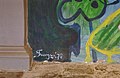
 Grenssteen bij Kerk - Lemiers - 20138500 - RCE.jpg 817 × 1,200; 331 KB
-
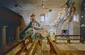
 Interieur muurschilderingen - Lemiers - 20138476 - RCE.jpg 1,200 × 785; 205 KB
-
 Interieur schilderingen (detail) - Lemiers - 20138480 - RCE.jpg 788 × 1,200; 191 KB
-
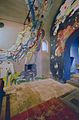
 Interieur schilderingen (details) - Lemiers - 20138479 - RCE.jpg 1,200 × 785; 195 KB
-
 Interieur schilderingen - Lemiers - 20138477 - RCE.jpg 796 × 1,200; 133 KB
-
 Interieur schilderingen - Lemiers - 20138478 - RCE.jpg 848 × 1,200; 213 KB
-
-

-
-

-

-

-

-

-
-

-

-

-
 Kapel - Lemiers - 20138468 - RCE.jpg 1,200 × 952; 270 KB
-
 Lemiers-Catharinakapel (1).JPG 4,000 × 3,000; 4.83 MB
-
 Lemiers-Catharinakapel (2).JPG 4,000 × 3,000; 4.66 MB
-
 LemiersKapel1.jpg 2,304 × 1,728; 897 KB
-
 LemiersKapel2.jpg 2,304 × 1,728; 950 KB
-
 Muurschilderingen - Lemiers - 20138475 - RCE.jpg 1,200 × 801; 195 KB
-
 Overzicht met kerk - Lemiers - 20138482 - RCE.jpg 1,200 × 788; 252 KB
-
 Overzicht zuidoostgevel met dakruiter - Lemiers - 20355854 - RCE.jpg 1,200 × 949; 218 KB
-
 Overzicht zuidwestgevel met dakruiter - Lemiers - 20355853 - RCE.jpg 956 × 1,200; 235 KB
-
 Sint-Catharinakapel (Lemiers) Hans Truijen April 2021 (01).jpg 1,908 × 4,032; 3.26 MB
-
 Sint-Catharinakapel (Lemiers) Hans Truijen April 2021 (02).jpg 1,908 × 4,032; 3.23 MB
-
 Sint-Catharinakapel (Lemiers) Hans Truijen April 2021 (03).jpg 1,908 × 4,032; 4.15 MB
-
 Sint-Catharinakapel (Lemiers) Hans Truijen April 2021 (05).jpg 4,032 × 1,908; 3.57 MB
-
 Sint-Catharinakapel (Lemiers) Hans Truijen April 2021 (07).jpg 1,908 × 4,032; 4.23 MB
-
 Sint-Catharinakapel (Lemiers) Hans Truijen April 2021 (08) Adlerstein.jpg 1,908 × 4,032; 4.48 MB
-
 Sint-Catharinakapel (Lemiers).jpg 1,908 × 4,032; 3.12 MB
-
 Sint-Catharinakapel.JPG 3,104 × 2,072; 1.19 MB
-
 Zij- en achtergevel foto nr. 87 - Lemiers - 20464504 - RCE.jpg 1,200 × 900; 156 KB
-
 Zuid-oost gevel - Lemiers - 20138470 - RCE.jpg 1,200 × 788; 233 KB
-
 Zuidgevel - Lemiers - 20138469 - RCE.jpg 1,200 × 788; 289 KB


_-_Lemiers_-_20138480_-_RCE.jpg)
_-_Lemiers_-_20138479_-_RCE.jpg)


_-_Lemiers_-_20001664_-_RCE.jpg)
_-_Lemiers_-_20001666_-_RCE.jpg)
,_altaar_-_Lemiers_-_20001665_-_RCE.jpg)
,_detail_-_Lemiers_-_20001667_-_RCE.jpg)
,_detail,_beschadiging_(ontpleistering)_-_Lemiers_-_20001668_-_RCE.jpg)
,_detail,_beschadiging_(ontpleistering)_-_Lemiers_-_20001669_-_RCE.jpg)
,_detail,_beschadiging_(ontpleistering)_-_Lemiers_-_20001671_-_RCE.jpg)
,_detail,_luchtkoker_-_Lemiers_-_20001670_-_RCE.jpg)
,_detail,_signatuur_(noordmuur)_-_Lemiers_-_20001672_-_RCE.jpg)
_-_Lemiers_-_20001661_-_RCE.jpg)
_-_Lemiers_-_20001662_-_RCE.jpg)
_-_Lemiers_-_20001663_-_RCE.jpg)

.JPG)
.JPG)


_Hans_Truijen_April_2021_(01).jpg)
_Hans_Truijen_April_2021_(02).jpg)
_Hans_Truijen_April_2021_(03).jpg)
_Hans_Truijen_April_2021_(05).jpg)
_Hans_Truijen_April_2021_(07).jpg)
_Hans_Truijen_April_2021_(08)_Adlerstein.jpg)
.jpg)


