Category:Tring Rural
English: Tring Rural is a civil parish in the Dacorum district, in the county of Hertfordshire, England.
civil parish in Hertfordshire, England | |||||
| Upload media | |||||
| Instance of | |||||
|---|---|---|---|---|---|
| Location | Dacorum, Hertfordshire, East of England, England | ||||
 | |||||
Subcategories
This category has the following 6 subcategories, out of 6 total.
Media in category "Tring Rural"
The following 200 files are in this category, out of 380 total.
(previous page) (next page)-
 A Black Swan on Wilstone Reservoir - geograph.org.uk - 4637221.jpg 500 × 333; 110 KB
-
 A Field at Alnwick Farm, Tring - geograph.org.uk - 4968439.jpg 3,105 × 2,069; 1.62 MB
-
 A Field Pond on Alnwick Farm - geograph.org.uk - 4968511.jpg 3,291 × 2,194; 3.1 MB
-
 A Flock of excited Bird Watchers at Wilstone Reservoir - geograph.org.uk - 4637247.jpg 2,794 × 1,794; 2.74 MB
-
 A mallard keeping an eye on what's happening - geograph.org.uk - 4019229.jpg 1,000 × 1,276; 1.02 MB
-
 A Meeting in Wilstone Village Hall - geograph.org.uk - 4751298.jpg 3,109 × 2,072; 2.44 MB
-
 A Mountain of Straw on Alnwick Farm - geograph.org.uk - 4968450.jpg 3,541 × 1,675; 2.28 MB
-
 A Party visits the Millhoppers Nature Reserve - geograph.org.uk - 4804982.jpg 3,264 × 2,448; 4.78 MB
-

-
 A summer view of the Ridge and Furrow at Wilstone - geograph.org.uk - 4102369.jpg 3,362 × 2,241; 1.21 MB
-
 A tree struck by lightning on Alnwick Farm - geograph.org.uk - 4968495.jpg 2,288 × 3,433; 3.22 MB
-

-
 A View over the Frozen Startops Reservoir, near Tring - geograph.org.uk - 3258495.jpg 4,000 × 3,000; 2.34 MB
-
 Access path goes over the brook - geograph.org.uk - 2680005.jpg 640 × 480; 142 KB
-
 Advertizing Ovaltine - geograph.org.uk - 4710822.jpg 4,000 × 2,664; 1.83 MB
-
 All Saints Church, Long Marston - geograph.org.uk - 5677262.jpg 2,304 × 1,728; 836 KB
-
 All Saints Churchyard, Long Marston - geograph.org.uk - 6309947.jpg 4,557 × 3,642; 2.9 MB
-
 All Saints' church, Long Marston - geograph.org.uk - 4135477.jpg 4,320 × 3,240; 4.43 MB
-
 All Saints, Long Marston - geograph.org.uk - 1954527.jpg 640 × 462; 144 KB
-
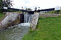 An overflowing Aylesbury Arm Lock 5 - geograph.org.uk - 4890112.jpg 800 × 533; 145 KB
-
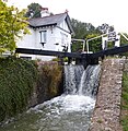 An overflowing Black Jack's Lock - geograph.org.uk - 4890106.jpg 780 × 800; 217 KB
-
 Approaching Bates Boatyard from Aylesbury in the Autumn - geograph.org.uk - 2851320.jpg 2,617 × 1,962; 1.36 MB
-
 Approaching Marsworth Reservoir from the South - geograph.org.uk - 5210100.jpg 3,275 × 2,456; 2.9 MB
-
 Aylesbury Arm - geograph.org.uk - 2167396.jpg 640 × 480; 78 KB
-

-
 Aylesbury Arm Lock 6 - geograph.org.uk - 4890130.jpg 800 × 523; 129 KB
-
 Aylesbury Arm Lock 7 - geograph.org.uk - 4890155.jpg 800 × 476; 138 KB
-
 Aylesbury arm looking towards Wilstone bridge - geograph.org.uk - 5211093.jpg 5,184 × 3,456; 7.28 MB
-
 Aylesbury Branch of Grand Union Canal - geograph.org.uk - 4135379.jpg 4,320 × 3,240; 5.01 MB
-
 Aylesbury Ring path - geograph.org.uk - 3154207.jpg 1,600 × 1,068; 448 KB
-
 Back of the Queen's Head pub, Long Marston - geograph.org.uk - 4135422.jpg 4,320 × 3,240; 3.71 MB
-
 Bates Boatyard - geograph.org.uk - 5212204.jpg 5,202 × 3,465; 3.11 MB
-
 Bend on Lower Icknield Way, Tringford - geograph.org.uk - 5642530.jpg 2,304 × 1,728; 888 KB
-
 Black Headed Gulls on Temporary Island, Startops Reservoir - geograph.org.uk - 2777716.jpg 3,005 × 2,253; 1.53 MB
-
 Black Jack's Lock House - geograph.org.uk - 4713487.jpg 4,000 × 2,664; 2.28 MB
-
 Blackthorn blossoms in Millhoppers Reserve - geograph.org.uk - 4804987.jpg 2,748 × 2,061; 1 MB
-
 Blackthorn in bloom in Millhoppers Reserve - geograph.org.uk - 4804993.jpg 3,166 × 2,375; 2.22 MB
-
 Bottoms up ^ - geograph.org.uk - 4019234.jpg 1,039 × 1,000; 779 KB
-
 Brick buildings off Cheddington Lane - geograph.org.uk - 2182845.jpg 640 × 480; 105 KB
-

-

-
 Bridge 3, Grand Union Canal, Welford Arm - geograph.org.uk - 3998037.jpg 640 × 480; 118 KB
-
 Bridge 4, Grand Junction Canal - Aylesbury Arm - geograph.org.uk - 2871382.jpg 4,000 × 3,000; 4.75 MB
-
 Bridge 4a over the Wendover Arm of the Grand Union Canal - geograph.org.uk - 4637031.jpg 3,648 × 2,736; 4.91 MB
-
 Bridge 5, Aylesbury Arm, Grand Union Canal - geograph.org.uk - 4166750.jpg 3,648 × 2,736; 3.58 MB
-
 Bridge 5, Grand Junction Canal - Aylesbury Arm - geograph.org.uk - 2871404.jpg 4,000 × 3,000; 4.67 MB
-
 Bridge 6, Aylesbury Arm, Grand Union Canal - geograph.org.uk - 4166745.jpg 3,648 × 2,736; 3.99 MB
-
 Bridge 6, Grand Junction Canal - Aylesbury Arm - geograph.org.uk - 2871421.jpg 4,000 × 3,000; 4.78 MB
-
 Bridge over a section of the disused canal - geograph.org.uk - 6008865.jpg 4,608 × 3,456; 5.05 MB
-
 Bridge over the stream in Millhoppers Reserve - geograph.org.uk - 4804996.jpg 2,971 × 2,228; 3.05 MB
-
 Bridge parapet and lock, Wilstone - geograph.org.uk - 3819250.jpg 1,000 × 880; 902 KB
-
 Bridge Under Repair - geograph.org.uk - 2167377.jpg 640 × 480; 73 KB
-
 Broken Parapet of Dixon's Gap Bridge, Wilstone - geograph.org.uk - 4201379.jpg 3,714 × 2,476; 1.55 MB
-
 Bungalows on Tring Road, Wilstone - geograph.org.uk - 5646228.jpg 2,286 × 1,704; 1,014 KB
-
 Canal Barges on the Aylesbury Canal at Wilstone - geograph.org.uk - 4964886.jpg 3,264 × 2,448; 2.17 MB
-
 Canal restoration - geograph.org.uk - 3547074.jpg 2,048 × 1,536; 576 KB
-
 Canalside dereliction near Wilstone - geograph.org.uk - 5211096.jpg 5,175 × 3,006; 3.31 MB
-
 Cattle in Field behind Wilstone Reservoir - geograph.org.uk - 4102433.jpg 2,557 × 1,918; 871 KB
-
 Cattle on Alnwick Farm - geograph.org.uk - 4968425.jpg 3,648 × 2,432; 3.29 MB
-
 Cemetery Corner on the Lower Icknield Way, near Tring - geograph.org.uk - 2917851.jpg 2,672 × 2,004; 782 KB
-
 Cemetery Corner on the Lower Icknield Way, near Tring - geograph.org.uk - 2917915.jpg 2,408 × 1,806; 864 KB
-
 Cheddington Lane, Long Marston - geograph.org.uk - 3559343.jpg 3,264 × 2,448; 2.95 MB
-
 Clouds in the Canal on the Wendover Arm - geograph.org.uk - 4637034.jpg 3,207 × 2,405; 2.36 MB
-
 Clouds over Dixons Gap Lock - geograph.org.uk - 4714494.jpg 4,000 × 2,664; 2.62 MB
-
 Clouds over Wilstone Cemetery - geograph.org.uk - 2917924.jpg 2,752 × 2,064; 1.16 MB
-
 Clouds over Wilstone Reservoir - geograph.org.uk - 4102335.jpg 3,790 × 2,843; 1.15 MB
-
 Cold Comfort at Wilstone Cemetery - geograph.org.uk - 2917931.jpg 2,174 × 1,630; 770 KB
-

-
 Cottage between the Marsworth locks - geograph.org.uk - 5208869.jpg 5,184 × 3,456; 5.6 MB
-
 Cottages on Lower Icknield Road, Wilstone Green - geograph.org.uk - 5642535.jpg 2,172 × 1,534; 699 KB
-
 Cottages on Luke's Lane, Gubblecote - geograph.org.uk - 1954510.jpg 640 × 497; 144 KB
-
 Cow Parsley seed heads in the Millhoppers Reserve - geograph.org.uk - 4805859.jpg 3,095 × 2,320; 1.53 MB
-
 Cowslips in Millhoppers Nature Reserve - geograph.org.uk - 4805920.jpg 2,053 × 2,736; 1.1 MB
-
 Cruising on the Aylesbury Arm - geograph.org.uk - 4013966.jpg 640 × 480; 161 KB
-
 Current end of the Wendover Arm, Grand Union Canal - geograph.org.uk - 4158496.jpg 3,648 × 2,736; 2.94 MB
-
 Dam on Grand Union Canal Wendover Arm - geograph.org.uk - 2388186.jpg 4,000 × 3,000; 3.05 MB
-
 Damage to Dixon's Gap Canal Bridge in 2015 - geograph.org.uk - 4659082.jpg 3,372 × 2,529; 3.13 MB
-

-
 Dixon's Gate Bridge, Wilstone - geograph.org.uk - 5677250.jpg 2,304 × 1,728; 911 KB
-
 Dried up section of the Aylesbury Arm - geograph.org.uk - 4890135.jpg 800 × 600; 172 KB
-
 Dry canal bed – Grand Union Canal - geograph.org.uk - 6008864.jpg 4,608 × 3,456; 5.11 MB
-
 Eastern end of Wilstone Reservoir - geograph.org.uk - 4397024.jpg 1,387 × 1,000; 1.36 MB
-
 Edwardian post box in Little Tring - geograph.org.uk - 4782872.jpg 1,000 × 1,490; 1.52 MB
-
 End of public access - geograph.org.uk - 2680012.jpg 640 × 480; 106 KB
-
 End of the Arm - geograph.org.uk - 3539343.jpg 2,048 × 1,536; 489 KB
-
 Evening view across Startopsend Reservoir - geograph.org.uk - 3795738.jpg 1,567 × 1,000; 903 KB
-
 Evidence for a Ridge and Furrow Field at Wilstone Reservoir - geograph.org.uk - 4102392.jpg 3,035 × 2,023; 1.89 MB
-
 Evidence for Badgers in Millhoppers Reserve - geograph.org.uk - 4805934.jpg 3,414 × 2,276; 3.38 MB
-
 Evidence for Ridge ^ Furrow Field at Startops Reservoir - geograph.org.uk - 4238288.jpg 4,000 × 3,000; 2.82 MB
-
 Evidence of Ridge and Furrow Field at Startops Reservoir - geograph.org.uk - 5210562.jpg 3,466 × 2,310; 2.67 MB
-
 Farm Buildings at Boarscroft Farm, near Tring - geograph.org.uk - 4968478.jpg 3,511 × 2,340; 3.07 MB
-
 Field by the canal with balloon - geograph.org.uk - 3154209.jpg 1,600 × 1,068; 270 KB
-
 Field to the south of Wilstone Reservoir - geograph.org.uk - 6008862.jpg 4,608 × 3,456; 6.24 MB
-
 Fields near Puttenham - geograph.org.uk - 3559326.jpg 3,264 × 2,448; 2.82 MB
-
 Fieldscape near Long Marston - geograph.org.uk - 3559007.jpg 3,264 × 2,448; 3.11 MB
-
 Fishing at Startops Reservoir - geograph.org.uk - 4666473.jpg 3,704 × 2,778; 3.33 MB
-
 Flagpole fixing - geograph.org.uk - 1954533.jpg 640 × 541; 222 KB
-
 Flooded Ridge and Furrows at Long Marston, near Tring - geograph.org.uk - 3834460.jpg 3,646 × 1,286; 866 KB
-

-
 Footbridge over dry section of Wendover Arm - geograph.org.uk - 4396884.jpg 1,076 × 1,000; 1,012 KB
-
 Footbridge over Grand Union Canal Wendover Arm - geograph.org.uk - 2388170.jpg 4,000 × 3,000; 3.96 MB
-
 Footbridge over restoration of Wendover Arm - geograph.org.uk - 4396907.jpg 1,000 × 1,333; 1.16 MB
-
 Footpath over bridge 5 - geograph.org.uk - 5212151.jpg 4,840 × 2,995; 4.66 MB
-
 Footpath to Red House Farm - geograph.org.uk - 2680034.jpg 640 × 480; 63 KB
-
 Footpath, Wendover Arm to Wilstone Reservoir - geograph.org.uk - 4397007.jpg 1,000 × 1,333; 1.56 MB
-
 Footpaths crossing the lane - geograph.org.uk - 2680025.jpg 640 × 480; 60 KB
-
 GOC Cheddington 017 Sheep (10554077584).jpg 3,495 × 2,617; 3.25 MB
-

-

-

-

-

-

-

-

-

-

-

-
 Grand Union Canal - geograph.org.uk - 2167012.jpg 640 × 480; 93 KB
-
 Grand Union Canal - geograph.org.uk - 2167025.jpg 640 × 480; 92 KB
-
 Grand Union Canal - geograph.org.uk - 2167069.jpg 640 × 480; 87 KB
-
 Grand Union Canal - geograph.org.uk - 5671628.jpg 4,608 × 3,456; 3.63 MB
-
 Grand Union Canal Aylesbury Arm - geograph.org.uk - 5212172.jpg 4,878 × 3,173; 4.01 MB
-

-

-

-

-

-

-

-

-

-

-

-
 Greylag and Canada Geese on Marsworth Reservoir - geograph.org.uk - 5210591.jpg 3,242 × 2,431; 3.02 MB
-
 Greylag geese feeding in a field - geograph.org.uk - 4397043.jpg 1,529 × 1,000; 1.56 MB
-
 Greylag geese on Wilstone Reservoir - geograph.org.uk - 4397038.jpg 1,252 × 1,000; 1.08 MB
-
 Greylag Goose on Wilstone Reservoir - geograph.org.uk - 4397030.jpg 1,333 × 1,000; 1.17 MB
-
 Greylags on the march - geograph.org.uk - 4397047.jpg 1,206 × 1,000; 1.19 MB
-
 Gubblecote Cross ^ The Last Witch - geograph.org.uk - 1954515.jpg 640 × 480; 128 KB
-
 Gubblecote Village - geograph.org.uk - 2822212.jpg 4,000 × 3,000; 4.93 MB
-
 Harrowing the fields at Little Tring - geograph.org.uk - 2836656.jpg 1,880 × 1,410; 410 KB
-
 Hedge with May Blossom on Alnwick Farm - geograph.org.uk - 4968525.jpg 3,106 × 1,589; 1.87 MB
-
 Heron hunting at Wilstone Reservoir - geograph.org.uk - 4102411.jpg 2,239 × 1,679; 527 KB
-
 Hertfordshire boundary sign - geograph.org.uk - 5212201.jpg 4,013 × 2,751; 2.87 MB
-
 Houses in Long Marston - geograph.org.uk - 6309967.jpg 5,472 × 3,648; 2.7 MB
-
 Houses on New Road, Wilstone - geograph.org.uk - 5639874.jpg 2,304 × 1,728; 825 KB
-
 Information Board at Tringford Reservoir - geograph.org.uk - 5307270.jpg 2,592 × 1,944; 1.41 MB
-
 Inside St Cross, Wilstone - geograph.org.uk - 4921354.jpg 2,600 × 3,027; 1.53 MB
-

-
 Jefferies Lock , Wilstone - from the bridge - geograph.org.uk - 3819191.jpg 1,000 × 658; 691 KB
-
 Jefferies Lock from under Wilstone Bridge - geograph.org.uk - 3819252.jpg 1,000 × 718; 647 KB
-
 Jefferies Lock No 8 on the Aylesbury Arm - geograph.org.uk - 4890162.jpg 783 × 800; 248 KB
-
 Jefferies Lock, Aylesbury Arm - geograph.org.uk - 3819227.jpg 750 × 1,000; 815 KB
-
 Lambing Time at Wilstone Great Farm - geograph.org.uk - 2842823.jpg 3,141 × 2,355; 2.17 MB
-
 Land near Marsworth - geograph.org.uk - 4714484.jpg 3,880 × 2,560; 4.41 MB
-

-
 Limit of navigation, Wendover Arm - geograph.org.uk - 3994462.jpg 640 × 480; 108 KB
-

-
 Lining the canal sides on the Wendover Arm - geograph.org.uk - 5526712.jpg 3,294 × 2,471; 4.47 MB
-
 Little Egret fishing in steam at Wilstone Reservoir - geograph.org.uk - 4246230.jpg 1,518 × 1,139; 328 KB
-
 Little Egrets displaying at Wilstone Reservoir - geograph.org.uk - 4246176.jpg 1,361 × 1,021; 406 KB
-

-
 Lock 5, Grand Junction Canal - Aylesbury Arm - geograph.org.uk - 2871296.jpg 4,000 × 3,000; 4.8 MB
-
 Lock 6, Grand Junction Canal - Aylesbury Arm - geograph.org.uk - 2871311.jpg 4,000 × 3,000; 4.69 MB
-
 Lock 7, Grand Junction Canal - Aylesbury Arm - geograph.org.uk - 2871339.jpg 4,000 × 3,000; 4.99 MB
-
 Lock 8, Grand Junction Canal - Aylesbury Arm - geograph.org.uk - 2871347.jpg 4,000 × 3,000; 5 MB
-

-
 Lock No. 6, Aylesbury branch of the Grand Union Canal - geograph.org.uk - 4135397.jpg 4,320 × 3,240; 4.98 MB
-
 Lock on the Grand Union Canal, Wilstone - geograph.org.uk - 5677256.jpg 2,304 × 1,728; 837 KB
-
 Locks on the Grand Union Canal, Wilstone - geograph.org.uk - 5677255.jpg 2,304 × 1,728; 818 KB
-
 Lone tree at sunset, Wilstone - geograph.org.uk - 3548262.jpg 1,000 × 1,208; 882 KB
-
 Long Leys Farm, Long Marston - geograph.org.uk - 5677288.jpg 2,304 × 1,728; 855 KB
-
 Long Marston - Old Church Cottage from near the tower - geograph.org.uk - 3997029.jpg 1,333 × 1,000; 1.42 MB
-
 Long Marston Cricket Club - geograph.org.uk - 6310430.jpg 5,472 × 3,648; 2.71 MB
-
 Long Marston Village Hall - geograph.org.uk - 5677287.jpg 2,304 × 1,728; 848 KB
-

-
 Looking West across Marsworth Reservoir - geograph.org.uk - 4666456.jpg 3,524 × 2,643; 2.91 MB
-
 Low Water at Startops Reservoir January 2012 - geograph.org.uk - 2777688.jpg 3,648 × 2,736; 2.42 MB
-
 Low water level at Wilstone Reservoir - geograph.org.uk - 6008861.jpg 4,608 × 3,456; 6.02 MB
-
 Lower Icknield Way, Tringford - geograph.org.uk - 5642526.jpg 2,304 × 1,728; 824 KB
-
 Lower Icknield Way, Tringford - geograph.org.uk - 5642527.jpg 2,304 × 1,728; 920 KB
-
 Luke's Lane Gubblecote - geograph.org.uk - 1954507.jpg 640 × 480; 105 KB
-
 Manor House Farm, Marsworth - geograph.org.uk - 4238323.jpg 3,553 × 2,664; 1.65 MB
-
 Marsh Marigolds beside the stream in the Millhoppers Reserve - geograph.org.uk - 4805012.jpg 3,076 × 2,050; 2.02 MB
-
 Marston Gate Station - geograph.org.uk - 4859921.jpg 1,536 × 1,024; 487 KB
-

-
 Marsworth reservoir - geograph.org.uk - 2154125.jpg 640 × 441; 194 KB
-
 Marsworth Reservoir - geograph.org.uk - 3450196.jpg 2,985 × 1,990; 1.84 MB
-
 Marsworth reservoir - geograph.org.uk - 5208874.jpg 5,202 × 3,465; 4.06 MB
-
 Marsworth Reservoir near Startop's End - geograph.org.uk - 5284106.jpg 800 × 569; 151 KB
-
 Mealtime for the Black-headed Gulls - geograph.org.uk - 2836660.jpg 1,622 × 1,216; 446 KB
-
 Medieval Ridge and Furrow - Startops Reservoir, Near Tring - geograph.org.uk - 2842409.jpg 3,648 × 2,736; 2.54 MB
-
 Medieval Ridge and Furrow at Startops Reservoir, Tring - geograph.org.uk - 4731298.jpg 3,861 × 2,570; 5.24 MB
-

-
 Medieval Ridge and Furrow, Startops Reservoir, near Tring - geograph.org.uk - 2842419.jpg 3,648 × 2,736; 2.76 MB
-
 Members of the HMWT climb the steps at Wilstone Reservoir - geograph.org.uk - 4757124.jpg 3,433 × 2,574; 4.56 MB
-
 Memorial to America airmen - geograph.org.uk - 4135466.jpg 4,320 × 3,240; 4.72 MB
-
 Millhoppers Reserve Information Board - geograph.org.uk - 4804979.jpg 1,664 × 1,683; 540 KB
-


.jpg)
_in_Drayton_Beauchamp_-_geograph.org.uk_-_3656853.jpg)
,_Bridge_Number_3_-_geograph.org.uk_-_3745734.jpg)
,_Bridge_Number_4_-_geograph.org.uk_-_3745891.jpg)
,_Bridge_Number_4A_-_geograph.org.uk_-_3656900.jpg)
,_Former_Whitehouses_Pumping_Station_-_geograph.org.uk_-_3746239.jpg)
,_Head_of_navigation_-_geograph.org.uk_-_3736906.jpg)
,_Little_Tring_Stop_Lock_-_geograph.org.uk_-_3736897.jpg)
,_Unrestored_reach_near_Little_Tring_(1)_-_geograph.org.uk_-_3745759.jpg)
,_Unrestored_reach_near_Little_Tring_(2)_-_geograph.org.uk_-_3745877.jpg)
,_Unrestored_reach_near_Little_Tring_(3)_-_geograph.org.uk_-_3745917.jpg)
,_Unrestored_reach_near_Little_Tring_(4)_-_geograph.org.uk_-_3746152.jpg)


_-_geograph.org.uk_-_4162659.jpg)
_-_geograph.org.uk_-_4163367.jpg)


