Category:Borough of Dacorum

local government district in Hertfordshire, England    | |||||
| Upload media | |||||
| Instance of | |||||
|---|---|---|---|---|---|
| Location | Hertfordshire, East of England, England | ||||
| Capital | |||||
| Legislative body |
| ||||
| Headquarters location | |||||
| Inception |
| ||||
| Population |
| ||||
| Area |
| ||||
| Different from | |||||
| official website | |||||
 | |||||
Subcategories
This category has the following 21 subcategories, out of 21 total.
Media in category "Borough of Dacorum"
The following 200 files are in this category, out of 288 total.
(previous page) (next page)-
-
 A Footpath across Boxmoor Common - geograph.org.uk - 5522948.jpg 2,805 × 2,476; 4.14 MB
-
 Anchor Lane - geograph.org.uk - 2168506.jpg 640 × 480; 64 KB
-
 Apsley Community Centre - geograph.org.uk - 5328671.jpg 1,600 × 1,200; 379 KB
-
 Autumn leaves, Boxmoor - geograph.org.uk - 5555093.jpg 1,067 × 1,600; 941 KB
-
 B ^ Q store and tower block at Hemel Hempstead - geograph.org.uk - 5436337.jpg 5,202 × 3,465; 3.11 MB
-
 Bennetts End Road, Hemel Hempstead - geograph.org.uk - 2167548.jpg 4,320 × 3,240; 4.78 MB
-
 Bourne End junction, A41 - geograph.org.uk - 3008741.jpg 640 × 480; 62 KB
-
 Bowling Green at Gadebridge Park - geograph.org.uk - 1971117.jpg 3,100 × 1,800; 3.43 MB
-
 Boxmoor Cricket Club pavilion - geograph.org.uk - 2263566.jpg 2,048 × 1,536; 1.43 MB
-
 BP petrol station on Breakspear Way - geograph.org.uk - 5462465.jpg 1,994 × 1,462; 856 KB
-
 Breakspear Park over the trees - geograph.org.uk - 4648833.jpg 640 × 480; 98 KB
-
 Bridge on Three Cherry Trees lane removed - geograph.org.uk - 2517760.jpg 3,248 × 2,196; 1.22 MB
-
 Buncefield Lane, Cupid Green - geograph.org.uk - 3638199.jpg 2,048 × 1,536; 2.87 MB
-
 Bungalow on Fletcher Way, Hemel Hempstead - geograph.org.uk - 4443396.jpg 2,560 × 1,920; 1.88 MB
-

-
 B^Q at Boxmoor wharf, Grand Union Canal, Hemel Hempstead - geograph.org.uk - 1864570.jpg 1,600 × 1,200; 442 KB
-
 B^Q store in Hemel Hempstead - geograph.org.uk - 5264306.jpg 800 × 666; 171 KB
-
 Canal side explanation board - geograph.org.uk - 3079291.jpg 2,560 × 1,920; 1.86 MB
-
 Cattsdell, Hemel Hempstead - geograph.org.uk - 4443401.jpg 2,560 × 1,920; 1.9 MB
-
 Central Library - geograph.org.uk - 2168544.jpg 640 × 480; 81 KB
-
 Chalk-lake-Ridgeway-20060629-005.jpg 3,031 × 2,006; 1.38 MB
-
 Chartridge Way, Leverstock Green - geograph.org.uk - 4245139.jpg 2,498 × 1,834; 1.2 MB
-

-
 Chiltern Way - geograph.org.uk - 2171224.jpg 640 × 480; 72 KB
-
 Chiltern Way - geograph.org.uk - 2171238.jpg 640 × 480; 89 KB
-
 Chiltern Way - geograph.org.uk - 2171256.jpg 640 × 480; 128 KB
-
 Chiltern Way - geograph.org.uk - 2171319.jpg 640 × 480; 126 KB
-
 Chiltern Way - geograph.org.uk - 2171326.jpg 640 × 480; 70 KB
-
 Chiltern Way - geograph.org.uk - 2172296.jpg 640 × 480; 110 KB
-
 Chiltern Way - geograph.org.uk - 2172308.jpg 640 × 480; 85 KB
-
 Collapsing Bridge support - geograph.org.uk - 2517774.jpg 3,248 × 2,360; 1.55 MB
-

-
 Cottages at Two Waters - geograph.org.uk - 2047815.jpg 1,782 × 1,386; 578 KB
-
 Crane at Winkwell Dock - geograph.org.uk - 5261965.jpg 800 × 633; 117 KB
-
 Dacorum Borough Council Civic Centre - geograph.org.uk - 696199.jpg 640 × 486; 54 KB
-
 Dacorum Civic Centre.JPG 2,592 × 1,936; 1.5 MB
-
 Dacorum College - geograph.org.uk - 2828692.jpg 2,592 × 1,944; 778 KB
-
 Dacorum Heritage logo.png 1,424 × 670; 57 KB
-
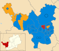
 Dacorum UK ward map 2007.svg 1,425 × 1,233; 371 KB
-
 Dacorum UK ward map 2011.svg 1,425 × 1,233; 371 KB
-
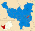 Dacorum UK ward map 2015.svg 1,425 × 1,233; 371 KB
-
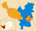 Dacorum UK ward map 2023.svg 1,425 × 1,233; 371 KB
-
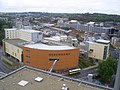 Debenhams Department Store Hemel Hempstead - geograph.org.uk - 2004319.jpg 2,048 × 1,536; 725 KB
-
 Departing Hemel Hempstead - geograph.org.uk - 4328014.jpg 1,578 × 1,038; 834 KB
-
 Derelict boat on Grand Union Canal - geograph.org.uk - 2366595.jpg 1,280 × 960; 607 KB
-
 Dickinson Quay, Apsley - geograph.org.uk - 4677537.jpg 1,024 × 768; 199 KB
-

-

-
 Entrance to Arriva Bus Depot, Hemel Hempstead - geograph.org.uk - 5104290.jpg 2,592 × 1,944; 1.38 MB
-
 Entrance to field on Bulstrode Lane - geograph.org.uk - 4432011.jpg 1,280 × 960; 719 KB
-
 Entrance to the Plough Roundabout, Hemel Hempstead - geograph.org.uk - 2416880.jpg 1,600 × 1,200; 537 KB
-
 Evans Wharf, Apsley - geograph.org.uk - 4677527.jpg 1,024 × 768; 161 KB
-
 Exit for A4251 on the A41, Bourne End - geograph.org.uk - 2395308.jpg 1,600 × 1,200; 484 KB
-

-
 Farm buildings - geograph.org.uk - 3453840.jpg 1,220 × 815; 495 KB
-
 Farmland near Pouchen End - geograph.org.uk - 3884637.jpg 640 × 430; 35 KB
-
 Farmland near Pouchen End - geograph.org.uk - 3892960.jpg 640 × 430; 36 KB
-
 Farmland, Pouchen End - geograph.org.uk - 4924583.jpg 640 × 426; 38 KB
-
 Felden Lane at the junction of Flaunden Lane - geograph.org.uk - 4432099.jpg 1,280 × 960; 413 KB
-
 Field by Rucklers Lane, Kings Langley - geograph.org.uk - 4433551.jpg 1,275 × 791; 375 KB
-
 Fields by Link Road, Hemel Hempstead - geograph.org.uk - 4444760.jpg 2,560 × 1,920; 1.9 MB
-
 Fields End Lane - geograph.org.uk - 5646482.jpg 640 × 480; 177 KB
-
 Fishery at Winkwell - geograph.org.uk - 2155957.jpg 640 × 374; 204 KB
-
 Fishing in the Gade - geograph.org.uk - 2160092.jpg 640 × 425; 244 KB
-
 Flats on Poynders Hill, Leverstock Green - geograph.org.uk - 4245542.jpg 2,560 × 1,920; 1.98 MB
-
 Flats on the A414, Hemel Hempstead - geograph.org.uk - 5641385.jpg 2,304 × 1,728; 832 KB
-
 Flats on Woolmer Drive, Leverstock Green - geograph.org.uk - 4245538.jpg 2,560 × 1,920; 1.99 MB
-
 Fletcher Way, Hemel Hempstead - geograph.org.uk - 4443397.jpg 2,560 × 1,920; 1.9 MB
-
-
 Footbridge over the River Bulbourne - geograph.org.uk - 3877920.jpg 4,320 × 3,240; 6.15 MB
-
 Footpath across Box Moor (1) - geograph.org.uk - 4704411.jpg 1,024 × 768; 121 KB
-
 Footpath across Box Moor (2) - geograph.org.uk - 4704414.jpg 1,024 × 768; 102 KB
-
 Footpath parallel with Sempill Road - geograph.org.uk - 4248122.jpg 640 × 480; 188 KB
-
 Footpath to Rucklers Lane - geograph.org.uk - 2172252.jpg 640 × 480; 92 KB
-
 Footpath-Northfield-Road-20060629-004.jpg 3,031 × 2,006; 1.06 MB
-
 Fork in the road on Roughdown Common. - geograph.org.uk - 2914584.jpg 3,456 × 2,304; 5.71 MB
-
 Former corner shop, Boxmoor - geograph.org.uk - 5554939.jpg 1,600 × 1,468; 651 KB
-
 Former Driving Test Centre, Hemel Hempstead - geograph.org.uk - 5050320.jpg 2,592 × 1,944; 1.37 MB
-
 Former Practical Driving Test Centre, Hemel Hempstead - geograph.org.uk - 5930261.jpg 2,592 × 1,944; 1.38 MB
-
 Freight Through Hemel Hempstead - geograph.org.uk - 4328013.jpg 1,584 × 1,038; 734 KB
-
 Gabion Boxes - geograph.org.uk - 4769172.jpg 640 × 426; 68 KB
-
 Galley Hill, Gadebridge - geograph.org.uk - 4443408.jpg 2,560 × 1,920; 1.83 MB
-
 Galley Hill, Hemel Hempstead - geograph.org.uk - 4427794.jpg 3,264 × 2,448; 2.83 MB
-
 Garage car park on Breakspear Way - geograph.org.uk - 5462464.jpg 2,048 × 1,536; 1.51 MB
-
 Gasometer beside London Road - geograph.org.uk - 2653791.jpg 3,112 × 2,176; 4.22 MB
-
 Grasmere Close, Hemel Hempstead - geograph.org.uk - 2167532.jpg 4,320 × 3,240; 4.2 MB
-
 Grass Mound - geograph.org.uk - 3674980.jpg 2,048 × 1,536; 889 KB
-
 Grazing cows in Boxmoor - geograph.org.uk - 3948687.jpg 2,560 × 1,920; 1.92 MB
-
 Green on Long John, Hemel Hempstead - geograph.org.uk - 4245120.jpg 2,560 × 1,920; 2.06 MB
-
 Grove Farm Cottages.jpg 3,264 × 2,448; 1.41 MB
-
 Heath Lane Cemetery - geograph.org.uk - 2168524.jpg 640 × 480; 93 KB
-
 Hemel Hempstead , Breakspear Way A414 - geograph.org.uk - 5979213.jpg 6,000 × 4,000; 7.49 MB
-
 Hemel Hempstead , Breakspear Way A414 - geograph.org.uk - 5979218.jpg 6,000 × 4,000; 7.81 MB
-
 Hemel Hempstead , Breakspear Way A414 - geograph.org.uk - 5979234.jpg 6,000 × 4,000; 7.5 MB
-
 Hemel Hempstead , Breakspear Way A414 - geograph.org.uk - 5979238.jpg 6,000 × 4,000; 7.47 MB
-
 Hemel Hempstead , Breakspear Way A414 - geograph.org.uk - 5979239.jpg 6,000 × 4,000; 5.48 MB
-
 Hemel Hempstead , Hemel Gateway - geograph.org.uk - 5979225.jpg 6,000 × 4,000; 6.91 MB
-
 Hemel Hempstead , Hemel Gateway - geograph.org.uk - 5979228.jpg 4,000 × 6,000; 6.71 MB
-
 Hemel Hempstead , Hemel Hempstead Scenery - geograph.org.uk - 5979231.jpg 6,000 × 4,000; 6.52 MB
-
 Hemel Hempstead , Jarman Park - geograph.org.uk - 6135954.jpg 3,648 × 2,736; 6.49 MB
-
 Hemel Hempstead , Jarman Park - geograph.org.uk - 6135955.jpg 3,648 × 2,736; 7.06 MB
-
 Hemel Hempstead , Maylands Avenue - geograph.org.uk - 5979235.jpg 6,000 × 4,000; 6.12 MB
-
 Hemel Hempstead , Tesco - geograph.org.uk - 5929111.jpg 3,264 × 1,836; 1.15 MB
-
 Hemel Hempstead , Two Waters Way - geograph.org.uk - 6135956.jpg 3,648 × 2,736; 6.03 MB
-
 Hemel Hempstead - High Street - geograph.org.uk - 5273595.jpg 1,600 × 1,200; 454 KB
-
 Hemel Hempstead Methodist Church (1) - geograph.org.uk - 4614290.jpg 3,648 × 2,736; 2.48 MB
-
 Hemel Hempstead Methodist Church (2) - geograph.org.uk - 4614300.jpg 3,648 × 2,736; 2.53 MB
-
 Hemel Hempstead Telephone Exchange (1) - geograph.org.uk - 4643942.jpg 3,648 × 2,736; 2.38 MB
-
 Hemel Hempstead Telephone Exchange (2) - geograph.org.uk - 4643970.jpg 3,648 × 2,736; 2.53 MB
-
 Hemel Hempstead Town Cricket Club pavilion - geograph.org.uk - 2263547.jpg 2,048 × 1,536; 1.39 MB
-
 Hemel Hempstead Water Gardens - geograph.org.uk - 5746255.jpg 640 × 480; 124 KB
-
 Hemel Hempstead, Northridge Park - geograph.org.uk - 4332239.jpg 640 × 472; 62 KB
-

-

-

-

-

-
 Hemel Hempstead, Tudor Rose - geograph.org.uk - 4333760.jpg 640 × 480; 70 KB
-
 Holiday Inn Express at Apsley - geograph.org.uk - 1935819.jpg 2,048 × 1,536; 684 KB
-
 House at Winkwell - geograph.org.uk - 2155952.jpg 640 × 387; 154 KB
-
 House in Piccotts End - geograph.org.uk - 4443120.jpg 2,560 × 1,920; 1.9 MB
-
 House off Queensway - geograph.org.uk - 2501501.jpg 3,035 × 2,349; 1.6 MB
-
 House on Felden Lane - geograph.org.uk - 6240302.jpg 1,920 × 1,280; 1.76 MB
-
 Houses at Apsley - geograph.org.uk - 2160136.jpg 640 × 454; 244 KB
-
 Houses at Boxmoor - geograph.org.uk - 2156012.jpg 640 × 427; 199 KB
-
 Houses off Sempill Road - geograph.org.uk - 4248102.jpg 640 × 428; 142 KB
-
 Houses on Bennett's End Road - geograph.org.uk - 4245537.jpg 2,560 × 1,920; 2.04 MB
-
 Houses on Lombardy Close, Leverstock Green - geograph.org.uk - 4245147.jpg 2,560 × 1,920; 1.38 MB
-
 Houses on Pancake Lane, Leverstock Green - geograph.org.uk - 4245563.jpg 2,466 × 1,788; 1.42 MB
-
 Houses on Piccotts End Road - geograph.org.uk - 4443157.jpg 2,440 × 1,748; 1.14 MB
-
 Houses on Redbourn Road, Cupid Green - geograph.org.uk - 5467293.jpg 2,048 × 1,536; 1.42 MB
-
 Industrial buildings by Swallowdale Lane - geograph.org.uk - 3638041.jpg 2,048 × 1,497; 938 KB
-
 Industrial buildings on Maylands Avenue, Adeyfield - geograph.org.uk - 3638009.jpg 2,048 × 1,536; 1.48 MB
-
 Industrial estate by Swallowdale Lane - geograph.org.uk - 3638045.jpg 2,042 × 1,511; 1.15 MB
-
 Inside the former Driving Test Centre, Hemel Hempstead - geograph.org.uk - 5050328.jpg 2,592 × 1,944; 1.43 MB
-
 Iron Bridge - geograph.org.uk - 2361123.jpg 2,048 × 1,536; 914 KB
-

-

-
 KD-Tower-Plough-Magic-Roundabout Hemel-Hempstead.jpg 2,664 × 3,996; 3.63 MB
-
 Lane towards Little Revel End - geograph.org.uk - 4649039.jpg 640 × 480; 216 KB
-

-
 Leisure World, Hemel Hempstead - geograph.org.uk - 2167542.jpg 4,320 × 3,240; 3.92 MB
-
 Leverstock Green Road - geograph.org.uk - 3638364.jpg 2,048 × 1,536; 1.49 MB
-
 Leverstock Green Way - geograph.org.uk - 4245543.jpg 2,560 × 1,920; 1.98 MB
-

-
 Lime Walk at the junction of Sheephouse Road - geograph.org.uk - 4245122.jpg 2,560 × 1,920; 1.98 MB
-
 Lime Walk at the junction of St Albans Hill - geograph.org.uk - 4245124.jpg 2,560 × 1,920; 2.17 MB
-
 Link Road at the junction of Leighton Buzzard - geograph.org.uk - 4443405.jpg 2,560 × 1,920; 1.9 MB
-
 London Road at the junction of Fishery Road - geograph.org.uk - 3948712.jpg 2,560 × 1,920; 1.96 MB
-
 London Road at the junction of Two Waters Road - geograph.org.uk - 3948724.jpg 2,560 × 1,920; 2.19 MB
-
 London Road Trade Centre - geograph.org.uk - 3241263.jpg 640 × 480; 55 KB
-
 London Road, Bourne End - geograph.org.uk - 2135172.jpg 804 × 593; 138 KB
-
 London Road, Boxmoor - geograph.org.uk - 3948692.jpg 2,560 × 1,920; 2 MB
-
 London Road, Boxmoor - geograph.org.uk - 4704399.jpg 1,024 × 768; 143 KB
-
 London Road, Two Waters - geograph.org.uk - 3948725.jpg 2,560 × 1,920; 2 MB
-
 Long John from Sheephouse Road - geograph.org.uk - 4245113.jpg 2,560 × 1,920; 1.97 MB
-
 Longcroft Lane at the junction of Flaunden Lane - geograph.org.uk - 4431914.jpg 1,280 × 960; 686 KB
-
 Longcroft Lane at the junction of Flaunden Lane - geograph.org.uk - 4431924.jpg 1,280 × 960; 747 KB
-
 Longcroft Lane, Felden - geograph.org.uk - 4431907.jpg 1,280 × 960; 573 KB
-
 Longcroft Lane, Felden - geograph.org.uk - 4431969.jpg 1,280 × 960; 706 KB
-
 Longcroft Lane, Felden - geograph.org.uk - 6240313.jpg 1,836 × 1,144; 1.36 MB
-
 Longdean School sign.jpg 4,000 × 3,000; 4.45 MB
-
 Looking up the line from Apsley station - geograph.org.uk - 2368254.jpg 1,280 × 960; 616 KB
-
 Magic roundabout signs, Hemel Hempstead - geograph.org.uk - 4704470.jpg 1,024 × 768; 176 KB
-
 Malmscroft, Hemel Hempstead - geograph.org.uk - 2167533.jpg 4,320 × 3,240; 4.95 MB
-
 Marlins Turn, Hemel Hempstead - geograph.org.uk - 4427782.jpg 3,264 × 2,448; 2.91 MB
-
 Marlowes, Hemel Hempstead - geograph.org.uk - 2746653.jpg 4,000 × 3,000; 2.52 MB
-
 Mayfields Court, Adeyfield - geograph.org.uk - 3638003.jpg 2,034 × 1,518; 1.12 MB
-
 Maylands Avenue at the intersection with Eaton Road - geograph.org.uk - 3500393.jpg 2,592 × 1,936; 2.09 MB
-
 Maylands Avenue, Cupid Green - geograph.org.uk - 3638389.jpg 2,048 × 1,536; 1.4 MB
-
 Milestone 63 - geograph.org.uk - 4797578.jpg 4,896 × 3,672; 3.74 MB
-
 Milestone 65 - geograph.org.uk - 4797581.jpg 4,411 × 3,138; 2.47 MB
-
 Milestone 66 - geograph.org.uk - 4797586.jpg 3,125 × 2,388; 1.97 MB
-
 Mixed use canalside development, Apsley - geograph.org.uk - 4704380.jpg 1,024 × 768; 154 KB
-
 Model of the old Hemel - geograph.org.uk - 3497368.jpg 640 × 480; 82 KB
-
 Modern office block on Maylands Avenue - geograph.org.uk - 3638026.jpg 2,048 × 1,536; 1.62 MB
-
 Modern Spiral Footbridge over the Grand Union canal - geograph.org.uk - 1935836.jpg 2,048 × 1,536; 680 KB
-
 New care home on Redbourn Road, Hemel Hempstead - geograph.org.uk - 4443743.jpg 2,482 × 1,812; 1.35 MB
-
 New housing on Cherry Tree Grove, Cupid Green - geograph.org.uk - 3638434.jpg 1,940 × 1,386; 877 KB
-
 New offices on Maylands Avenue, Hemel Hempstead - geograph.org.uk - 4443426.jpg 2,560 × 1,920; 1.9 MB
-
 Nickey Line - geograph.org.uk - 2168560.jpg 640 × 480; 144 KB
-
 Nickey Line - geograph.org.uk - 2169669.jpg 640 × 480; 124 KB
-
 Nickey Line - geograph.org.uk - 2169687.jpg 640 × 480; 142 KB
-
 Nickey Line now a footpath - geograph.org.uk - 2500980.jpg 2,442 × 3,022; 1.24 MB
-

-
 Notice outside former Driving Test Centre, Hemel Hempstead - geograph.org.uk - 5930283.jpg 2,592 × 1,944; 1.39 MB
-
 Office building, Hemel Hempstead - geograph.org.uk - 2167581.jpg 4,320 × 3,240; 3.78 MB
-
 Offices on Maylands Road, Adeyfield - geograph.org.uk - 4444763.jpg 2,560 × 1,920; 1.9 MB
-
 Old fingerpost on Piccotts End Road - geograph.org.uk - 4443384.jpg 2,560 × 1,920; 2.28 MB
-
 Old fingerpost on Piccotts End Road - geograph.org.uk - 4443387.jpg 2,560 × 1,920; 1.99 MB
-
 Old Fishery Lane Bridge No 148 - geograph.org.uk - 5262828.jpg 800 × 542; 158 KB
-
 Old Kodak offices from Leighton Buzzard Road - geograph.org.uk - 2416846.jpg 1,600 × 1,200; 658 KB
-
 Orchard Farm - geograph.org.uk - 3827174.jpg 640 × 480; 70 KB
-
 Over-flow of River Gade on Grand Union Canal - geograph.org.uk - 2047794.jpg 3,648 × 2,736; 4.74 MB
-
 Passing under the railway near Winkwell - geograph.org.uk - 5328052.jpg 1,600 × 1,200; 677 KB
-
 Pennine Way Sports Ground - geograph.org.uk - 4120961.jpg 4,608 × 3,456; 3.21 MB
-
 Petrol Station, Hemel Hempstead - geograph.org.uk - 2167579.jpg 4,320 × 3,240; 3.75 MB
-
 Petrol stations, Hemel Hempstead - geograph.org.uk - 2167537.jpg 4,320 × 3,240; 4.35 MB
-
 Piccotts End Road - geograph.org.uk - 4443393.jpg 2,560 × 1,835; 1.73 MB
_Lawn_Lane,_Hemel_Hempstead_-_geograph.org.uk_-_4248550.jpg)


_-_geograph.org.uk_-_4704411.jpg)
_-_geograph.org.uk_-_4704414.jpg)


_-_geograph.org.uk_-_4614290.jpg)
_-_geograph.org.uk_-_4614300.jpg)
_-_geograph.org.uk_-_4643942.jpg)
_-_geograph.org.uk_-_4643970.jpg)


_-_geograph.org.uk_-_4332155.jpg)
_-_geograph.org.uk_-_4332169.jpg)


