Category:Walmer
town in the district of Dover in Kent, England  | |||||
| Upload media | |||||
| Instance of | |||||
|---|---|---|---|---|---|
| Location | Dover, Kent, South East England, England | ||||
| official website | |||||
 | |||||
Subcategories
This category has the following 2 subcategories, out of 2 total.
B
M
Media in category "Walmer"
The following 200 files are in this category, out of 439 total.
(previous page) (next page)-
 1 The Beach, Lower Walmer - geograph.org.uk - 3838085.jpg 896 × 1,207; 167 KB
-
 1-10, Station Cottages, Station Drive - geograph.org.uk - 4288209.jpg 913 × 684; 158 KB
-
 12 Liverpool Road - geograph.org.uk - 4067829.jpg 1,115 × 819; 204 KB
-
 14, The Beach - geograph.org.uk - 4076444.jpg 783 × 1,040; 181 KB
-
 14, The Beach - geograph.org.uk - 4290379.jpg 783 × 1,040; 184 KB
-
 14, The Strand - geograph.org.uk - 5708919.jpg 2,448 × 3,264; 1.63 MB
-
 22, The Beach - geograph.org.uk - 6162616.jpg 3,264 × 2,448; 2.35 MB
-
 32, The Strand - geograph.org.uk - 5120308.jpg 2,448 × 3,264; 1.92 MB
-
 35, Granville Road - geograph.org.uk - 5711549.jpg 3,264 × 2,448; 3.78 MB
-
 366 Dover Road, Walmer - geograph.org.uk - 4024808.jpg 640 × 428; 89 KB
-
 4, Marine Road - geograph.org.uk - 6172769.jpg 3,264 × 2,448; 2.14 MB
-
 42, The Strand - geograph.org.uk - 5120320.jpg 2,448 × 3,264; 2.14 MB
-

-
 6, The Beach - geograph.org.uk - 4904376.jpg 2,448 × 3,264; 1.95 MB
-
 6, The Beach - geograph.org.uk - 5119352.jpg 2,448 × 3,264; 1.94 MB
-
 64 ^ 65, The Strand - geograph.org.uk - 5986808.jpg 2,448 × 3,264; 1.68 MB
-
 66 ^ 67, The Strand - geograph.org.uk - 5986803.jpg 2,448 × 3,264; 1.71 MB
-
 67c ^ d, York Road - geograph.org.uk - 5709778.jpg 2,448 × 3,264; 2.19 MB
-
 73, Victoria Road - geograph.org.uk - 4291219.jpg 745 × 1,008; 174 KB
-
 73, Victoria Road - geograph.org.uk - 4527487.jpg 2,448 × 3,264; 1.9 MB
-
 A nearer view - geograph.org.uk - 3715030.jpg 1,077 × 807; 202 KB
-
 A tranquil sea - geograph.org.uk - 4024848.jpg 640 × 480; 85 KB
-
 Adamson's Skoda car dealership, Walmer - geograph.org.uk - 2821452.jpg 4,320 × 3,240; 3.79 MB
-
 Alterations to 35, Granville Road - geograph.org.uk - 5118311.jpg 3,264 × 2,448; 1.69 MB
-
 Apples - geograph.org.uk - 5570184.jpg 1,024 × 768; 202 KB
-
 Approaching Kingsdown - geograph.org.uk - 236769.jpg 640 × 480; 109 KB
-
 Archery Square, Walmer - geograph.org.uk - 4430218.jpg 2,272 × 1,704; 768 KB
-
 Armillary Sphere, Walmer Castle gardens - geograph.org.uk - 5558957.jpg 1,280 × 850; 974 KB
-
 Ashley Scott, 60, The Strand - geograph.org.uk - 5711526.jpg 2,448 × 3,264; 2.2 MB
-
 Autumn's harvest - geograph.org.uk - 5570181.jpg 1,024 × 768; 306 KB
-
 Balfour Road, Walmer - geograph.org.uk - 2821486.jpg 4,320 × 3,240; 3.49 MB
-
 Barracks Development - geograph.org.uk - 3644992.jpg 1,159 × 880; 190 KB
-
 Beach at Walmer - geograph.org.uk - 2735183.jpg 640 × 350; 56 KB
-
 Beach Court - geograph.org.uk - 2735177.jpg 640 × 430; 72 KB
-
 Beach Mews, Kingsdown Road - geograph.org.uk - 5495239.jpg 3,264 × 2,448; 3.52 MB
-
 Beach near Walmer Castle - geograph.org.uk - 2731324.jpg 640 × 347; 52 KB
-
 Beach, Lower Walmer - geograph.org.uk - 2735188.jpg 640 × 320; 51 KB
-
 Beach, Walmer - geograph.org.uk - 5573569.jpg 640 × 480; 154 KB
-
 Beech tree in the paddock, Walmer Castle - geograph.org.uk - 2104192.jpg 640 × 473; 149 KB
-
 Before and After (^) - geograph.org.uk - 1231630.jpg 640 × 480; 72 KB
-
 Benches by the White Cliffs Trail - geograph.org.uk - 2731329.jpg 640 × 430; 57 KB
-
 Bikers on the Strand - geograph.org.uk - 2906603.jpg 1,024 × 768; 167 KB
-
 Blake Close - geograph.org.uk - 1980336.jpg 1,024 × 768; 250 KB
-
 Blenheim Rd - geograph.org.uk - 5846118.jpg 1,024 × 681; 152 KB
-
 Blenheim Rd - geograph.org.uk - 5846122.jpg 1,024 × 681; 158 KB
-
 Boat 'houses', Walmer - geograph.org.uk - 5573655.jpg 640 × 480; 144 KB
-
 Boat on the beach - geograph.org.uk - 2737176.jpg 640 × 480; 53 KB
-
 Boats on the beach at Walmer - geograph.org.uk - 5975840.jpg 1,600 × 1,104; 681 KB
-
 Boats on the shingle beach Lower Walmer - geograph.org.uk - 4617751.jpg 3,920 × 2,892; 3.98 MB
-
 Boundary Road, Kingsdown - geograph.org.uk - 4554529.jpg 2,272 × 1,704; 841 KB
-

-
 Bus stop and shelter, The Strand - geograph.org.uk - 5308107.jpg 2,448 × 3,264; 1.87 MB
-
 Bush on the beach - geograph.org.uk - 2735182.jpg 640 × 430; 53 KB
-
 By the Kent Coast Line, Middle Deal - geograph.org.uk - 2968691.jpg 640 × 347; 35 KB
-
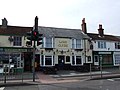
 Cambridge Arms, Walmer - geograph.org.uk - 2028720.jpg 3,488 × 2,616; 2.19 MB
-
 Cambridge Rd - geograph.org.uk - 2735185.jpg 640 × 430; 60 KB
-
 Campbell Road, Walmer - geograph.org.uk - 4430245.jpg 2,272 × 1,704; 721 KB
-
 Campbell Road, Walmer - geograph.org.uk - 4430247.jpg 2,272 × 1,704; 684 KB
-
 Canada Road, Walmer - geograph.org.uk - 4430237.jpg 2,272 × 1,704; 678 KB
-
 Car wash on the A258 Dover Road - geograph.org.uk - 801933.jpg 640 × 480; 160 KB
-
 Church of Jesus Christ of Latter Day Saints, Walmer - geograph.org.uk - 2030578.jpg 3,488 × 2,616; 2.16 MB
-
 Church Street, Walmer - geograph.org.uk - 4522134.jpg 2,272 × 1,704; 724 KB
-
 Cold Blow level crossing - geograph.org.uk - 801972.jpg 640 × 480; 253 KB
-
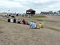
 Concert at the Deal Memorial bandstand, Walmer Green - geograph.org.uk - 6172795.jpg 3,264 × 2,448; 3.92 MB
-
 Cornwall Road (B2056) - geograph.org.uk - 3645102.jpg 1,175 × 881; 181 KB
-
 Cornwall Road, Walmer - geograph.org.uk - 5588573.jpg 640 × 480; 146 KB
-
 Court Road, Walmer - geograph.org.uk - 2821409.jpg 4,320 × 3,240; 3.83 MB
-
 Court Road, Walmer - geograph.org.uk - 4522137.jpg 2,272 × 1,704; 651 KB
-
 Cycle routes and paths at Walmer - geograph.org.uk - 3028380.jpg 3,872 × 2,592; 4.59 MB
-
 Cycle track alongside Walmer Castle - geograph.org.uk - 2906572.jpg 1,024 × 768; 183 KB
-

-
 Cycleway and footpath heading north - geograph.org.uk - 2731320.jpg 640 × 430; 62 KB
-
 Dahlia flowers, Walmer Castle - geograph.org.uk - 5568919.jpg 1,024 × 768; 314 KB
-
 Dahlias in the gardens of Walmer Castle - geograph.org.uk - 5568915.jpg 1,024 × 768; 389 KB
-
 Dairy Farm Walmer Port Elizabeth.jpg 1,600 × 976; 343 KB
-
 Dead tree on Kingdown Beach - geograph.org.uk - 2369823.jpg 3,072 × 2,304; 2.58 MB
-
 Deal - 2008 - geograph.org.uk - 3431193.jpg 2,272 × 1,704; 933 KB
-
 Deal - 2008 - geograph.org.uk - 3431195.jpg 2,272 × 1,704; 1.2 MB
-
 Deal - 2008 - geograph.org.uk - 3431196.jpg 2,272 × 1,704; 820 KB
-
 Deal - 2008 - geograph.org.uk - 3431199.jpg 2,272 × 1,704; 732 KB
-
 Deal Beach - geograph.org.uk - 2262206.jpg 2,272 × 1,704; 1.06 MB
-
 Deal Beach - geograph.org.uk - 2735236.jpg 640 × 430; 82 KB
-
 Deal Castle - geograph.org.uk - 4430262.jpg 2,272 × 1,704; 792 KB
-
 Deal Castle - geograph.org.uk - 5573260.jpg 640 × 428; 90 KB
-
 Deal Memorial Bandstand at Walmer - geograph.org.uk - 5070008.jpg 4,608 × 3,456; 3.35 MB
-
 Deal, The Stag - geograph.org.uk - 2199692.jpg 2,272 × 1,704; 882 KB
-
 Deal, Wall Post Box "George V." - geograph.org.uk - 2262307.jpg 1,278 × 1,704; 608 KB
-
 Derelict building, Kingsdown Road - geograph.org.uk - 5307207.jpg 3,192 × 2,448; 2.06 MB
-
 Derelict-looking building, Victoria Road - geograph.org.uk - 4901598.jpg 3,264 × 2,448; 3.91 MB
-
 Devon Avenue, Walmer - geograph.org.uk - 4430210.jpg 2,272 × 1,704; 767 KB
-
 Display of harvest fruit - geograph.org.uk - 5570192.jpg 768 × 1,024; 290 KB
-
 Dover Road, Walmer - geograph.org.uk - 2821415.jpg 4,320 × 3,240; 4.04 MB
-
 Dover Road, Walmer - geograph.org.uk - 4430222.jpg 2,272 × 1,704; 819 KB
-
 Downs Road, Walmer - geograph.org.uk - 4430208.jpg 2,272 × 1,704; 768 KB
-
 Downs Sailing Club - geograph.org.uk - 2735205.jpg 640 × 430; 53 KB
-
 Downs Sailing Club - geograph.org.uk - 5184869.jpg 3,318 × 2,212; 2.15 MB
-
 Downs Sailing Club, Lower Walmer - geograph.org.uk - 4040634.jpg 640 × 472; 75 KB
-
 Downs Sailing Club, Promenade - geograph.org.uk - 3838076.jpg 913 × 684; 144 KB
-
 Downs Sailing Club, Promenade - geograph.org.uk - 4071410.jpg 1,142 × 856; 190 KB
-
 DR161 on beach, Walmer - geograph.org.uk - 5573638.jpg 640 × 428; 115 KB
-
 Enclosure beside The Strand - geograph.org.uk - 4901582.jpg 3,264 × 2,448; 1.77 MB
-
 Entrance to Walmer Castle - geograph.org.uk - 4740660.jpg 640 × 548; 296 KB
-
 Equation of time - geograph.org.uk - 5558963.jpg 1,280 × 1,024; 546 KB
-
 Evicted Lifeboat and tractor stationed on the beach - geograph.org.uk - 4617758.jpg 3,810 × 2,728; 3.62 MB
-
 Fishing boat on Walmer beach - geograph.org.uk - 2564125.jpg 4,000 × 3,000; 3.11 MB
-
 Fishing boats and equipment, Walmer - geograph.org.uk - 5573561.jpg 640 × 480; 115 KB
-
 Fishing boats and equipment, Walmer - geograph.org.uk - 5573567.jpg 640 × 480; 173 KB
-
 Fishing clutter, Walmer - geograph.org.uk - 5573438.jpg 640 × 480; 129 KB
-
 Fishing clutter, Walmer - geograph.org.uk - 5573552.jpg 640 × 480; 120 KB
-
 Flats, Kingsdown Rd - geograph.org.uk - 2735175.jpg 640 × 430; 59 KB
-
 Flats, Telegraph Rd - geograph.org.uk - 5785373.jpg 640 × 480; 65 KB
-
 Footpath and bridleway junction near Coldblow Farm - geograph.org.uk - 2335590.jpg 3,072 × 2,304; 1.96 MB
-
 Footpath and bridleway junction near Mayers Road - geograph.org.uk - 2335635.jpg 3,072 × 2,304; 1.34 MB
-
 Footpath and Cycleway - geograph.org.uk - 2731319.jpg 640 × 430; 68 KB
-
 Footpath and cycleway - geograph.org.uk - 2731322.jpg 640 × 430; 62 KB
-
 Footpath and Cycleway heading towards Walmer - geograph.org.uk - 3710197.jpg 4,320 × 3,240; 4.3 MB
-
 Footpath and cycleway, Walmer beach - geograph.org.uk - 237229.jpg 640 × 480; 82 KB
-

-
 Footpath crosses Kingsdown Road - geograph.org.uk - 2369706.jpg 3,072 × 2,304; 3.45 MB
-
 Footpath from Liverpool Road, Walmer - geograph.org.uk - 2103812.jpg 640 × 447; 128 KB
-
 Footpath junction near Hawkshill Down - geograph.org.uk - 2335761.jpg 3,072 × 2,304; 2.46 MB
-
 Footpath junction near Hawkshill Freedown - geograph.org.uk - 2340336.jpg 3,072 × 2,304; 1.78 MB
-
 Footpath signpost - geograph.org.uk - 2731323.jpg 640 × 430; 70 KB
-
 Footpath to Dover Road - geograph.org.uk - 2370145.jpg 3,072 × 2,304; 2.93 MB
-
 Footpath to Kingsdown (2) - geograph.org.uk - 2340350.jpg 3,072 × 2,304; 2.33 MB
-
 Footpath to Kingsdown - geograph.org.uk - 2340320.jpg 3,072 × 2,304; 1.78 MB
-
 Footpath to Station Road - geograph.org.uk - 2335644.jpg 3,072 × 2,304; 2.19 MB
-
 Footpath to Walmer - geograph.org.uk - 2340382.jpg 3,072 × 2,304; 2.39 MB
-
 Former corner shop - geograph.org.uk - 3772670.jpg 1,207 × 905; 200 KB
-
 Freeman's Way - geograph.org.uk - 5785371.jpg 640 × 401; 68 KB
-
 Gardens at Walmer Castle - geograph.org.uk - 5568820.jpg 1,024 × 768; 349 KB
-
 Glasshouse in the kitchen garden, Walmer Castle - geograph.org.uk - 5568905.jpg 1,024 × 768; 342 KB
-
 Granville Arms, Pub Sign - geograph.org.uk - 2141050.jpg 2,304 × 3,072; 1.5 MB
-
 Granville Arms, Public House, Deal - geograph.org.uk - 2141047.jpg 3,072 × 2,304; 1.44 MB
-
 Greenhouses and gardens at Walmer Castle, Deal - geograph.org.uk - 2153429.jpg 1,024 × 768; 314 KB
-
 Gun on south-east terrace, Walmer Castle - geograph.org.uk - 5568791.jpg 1,024 × 768; 241 KB
-
 Guns at Walmer Castle - geograph.org.uk - 5568787.jpg 1,024 × 768; 199 KB
-
 Hard towards the sea - geograph.org.uk - 4024872.jpg 640 × 480; 134 KB
-
 Harvest display at Walmer - geograph.org.uk - 5570195.jpg 768 × 1,024; 244 KB
-
 Hawksdown, Walmer - geograph.org.uk - 4554141.jpg 2,272 × 1,704; 756 KB
-
 HawksdownMemorialDetail1.jpg 1,453 × 1,045; 460 KB
-
 Hawkshill Freedown - geograph.org.uk - 2340214.jpg 3,072 × 2,304; 2.28 MB
-
 Hawkshill Freedown - geograph.org.uk - 4458809.jpg 4,000 × 3,000; 4.23 MB
-
 Hawkshill Freedown Information Board - geograph.org.uk - 2340278.jpg 3,072 × 2,304; 1.88 MB
-
 Heading to Deal - geograph.org.uk - 2731339.jpg 640 × 430; 61 KB
-
 Hermes - panoramio (3).jpg 1,236 × 1,291; 383 KB
-
 House on Wellington Parade - geograph.org.uk - 4326503.jpg 640 × 480; 54 KB
-
 Houses along Liverpool Road - geograph.org.uk - 3777330.jpg 1,077 × 750; 237 KB
-
 Houses along The Beach - geograph.org.uk - 4076432.jpg 1,077 × 807; 216 KB
-
 Houses at Walmer - geograph.org.uk - 1408046.jpg 640 × 426; 102 KB
-
 Houses in Lower Walmer - geograph.org.uk - 2968677.jpg 640 × 430; 42 KB
-
 Houses on Marine Rd - geograph.org.uk - 2735249.jpg 640 × 430; 63 KB
-

-
 Houses under construction, Station Drive - geograph.org.uk - 3713525.jpg 913 × 684; 162 KB
-
 Houses, Archery Square, Walmer - geograph.org.uk - 5588732.jpg 640 × 428; 101 KB
-
 Houses, The Beach, Walmer - geograph.org.uk - 5588742.jpg 640 × 480; 123 KB
-
 Houses, The Beach, Walmer - geograph.org.uk - 5588747.jpg 640 × 428; 105 KB
-
 Huts on the Beach at Lower Walmer - geograph.org.uk - 3711125.jpg 4,320 × 3,240; 3.77 MB
-
 Ice cream van near Deal Castle - geograph.org.uk - 5573416.jpg 640 × 480; 119 KB
-
 Information board at Hawkshill Freedown - geograph.org.uk - 4458824.jpg 4,000 × 3,000; 4.08 MB
-
 Information Board for Hawkshill Freedown - geograph.org.uk - 2340270.jpg 3,072 × 2,304; 1.86 MB
-
 Interesting architecture - geograph.org.uk - 2731338.jpg 640 × 430; 87 KB
-
 Isolated Beach Hut, Kingsdown - geograph.org.uk - 3710189.jpg 4,320 × 3,240; 4.63 MB
-
 Julie in closeup on Walmer beach - geograph.org.uk - 4617754.jpg 3,936 × 2,914; 2.97 MB
-

-
 King Street, Walmer - geograph.org.uk - 4430228.jpg 2,272 × 1,704; 825 KB
-
 Kingsdown Beach - geograph.org.uk - 2369811.jpg 3,072 × 2,304; 2.61 MB
-
 Kingsdown Road, Walmer - geograph.org.uk - 4554144.jpg 2,272 × 1,704; 815 KB
-

-
 Kitchen garden at Walmer Castle - geograph.org.uk - 5568831.jpg 1,024 × 768; 346 KB
-
 Kitchen garden at Walmer Castle - geograph.org.uk - 5568880.jpg 1,024 × 768; 317 KB
-
 Kitchen garden, Walmer Castle - geograph.org.uk - 5568886.jpg 1,024 × 768; 316 KB
-
 Kitchen Garden, Walmer Castle - geograph.org.uk - 5917356.jpg 1,024 × 768; 336 KB
-
 Land off Station Road, Walmer, CT14 7RH - geograph.org.uk - 4288233.jpg 946 × 709; 215 KB
-
 Le Valiant Owen, 29 The Strand - geograph.org.uk - 3777310.jpg 656 × 881; 133 KB
-
 Lifeboat house, Walmer - geograph.org.uk - 5573659.jpg 640 × 480; 101 KB
-
 Listening to the band on Walmer Green - geograph.org.uk - 5127192.jpg 3,264 × 2,448; 2.16 MB
-
 Liverpool House, Walmer - geograph.org.uk - 2369681.jpg 3,072 × 2,304; 2.93 MB
-
 Liverpool Road - geograph.org.uk - 2335757.jpg 3,072 × 2,304; 2.6 MB
-
 Liverpool Road, Walmer - geograph.org.uk - 4457069.jpg 4,000 × 3,000; 4.48 MB
-
 Local shops on Dover Road, Walmer - geograph.org.uk - 348572.jpg 640 × 480; 179 KB
-
 Loggia-like building at Walmer Castle - geograph.org.uk - 5568875.jpg 683 × 1,024; 236 KB
-
 Looking N along shoreline, Kingsdown - geograph.org.uk - 1097175.jpg 640 × 480; 198 KB
-
 Looking NE along Telegraph Road - geograph.org.uk - 801445.jpg 640 × 480; 139 KB
-

-
 Looking north along The Strand, Lower Walmer - geograph.org.uk - 3838099.jpg 1,175 × 881; 199 KB
-
 Looking north-northwest along The Strand - geograph.org.uk - 4076425.jpg 1,142 × 856; 199 KB
-

-
 Looking northwest along Archery Square - geograph.org.uk - 4901523.jpg 2,448 × 3,264; 1.39 MB
-
 Looking northwest along Archery Square - geograph.org.uk - 5119339.jpg 3,264 × 2,448; 1.71 MB
-
 Looking northwest along The Strand, Lower Walmer - geograph.org.uk - 3839176.jpg 1,175 × 881; 205 KB
-
 Looking northwest along York Road - geograph.org.uk - 3842259.jpg 913 × 684; 143 KB
-
 Looking NW along St Richard's Road - geograph.org.uk - 801440.jpg 640 × 480; 176 KB
-
 Looking SW along Sydney Road - geograph.org.uk - 801450.jpg 640 × 480; 207 KB
-
 Lord Clyde, (closed) Public House, Deal - geograph.org.uk - 2141025.jpg 3,072 × 2,304; 1.54 MB
-
 Lord Clyde, Walmer - geograph.org.uk - 2029970.jpg 3,488 × 2,616; 2.19 MB
-
 Lord Nelson, Pub Sign, Deal - geograph.org.uk - 2141014.jpg 2,304 × 3,072; 1.56 MB
-
 Lord Nelson, Walmer - geograph.org.uk - 2029972.jpg 3,488 × 2,616; 2.22 MB
-
 Marine Road in Deal - geograph.org.uk - 3281038.jpg 1,500 × 1,000; 152 KB
-
 Marine Road, Walmer - geograph.org.uk - 4430258.jpg 2,272 × 1,704; 717 KB


.jpg)


_-_geograph.org.uk_-_1231630.jpg)


_-_geograph.org.uk_-_3645102.jpg)


_-_geograph.org.uk_-_2340350.jpg)


.jpg)


_Public_House,_Deal_-_geograph.org.uk_-_2141025.jpg)


