Category:West Berkshire District
unitary authority area in Berkshire, England  | |||||
| Upload media | |||||
| Instance of | |||||
|---|---|---|---|---|---|
| Location | Berkshire, South East England, England | ||||
| Capital | |||||
| Legislative body |
| ||||
| Population |
| ||||
| Area |
| ||||
| official website | |||||
 | |||||
Subcategories
This category has the following 70 subcategories, out of 70 total.
Media in category "West Berkshire District"
The following 57 files are in this category, out of 57 total.
-
 1 - panoramio (30).jpg 4,320 × 2,880; 10.94 MB
-
 1 - panoramio (31).jpg 4,320 × 2,880; 11.34 MB
-
 1 - panoramio (32).jpg 4,320 × 2,880; 11.64 MB
-
 1 - panoramio (33).jpg 4,320 × 2,880; 8.44 MB
-
 1 - panoramio (34).jpg 2,592 × 1,936; 1.75 MB
-
 1 - panoramio (35).jpg 4,320 × 2,880; 12.23 MB
-
 1 - panoramio (36).jpg 4,320 × 2,880; 12.04 MB
-
 1 - panoramio (37).jpg 4,320 × 2,880; 11.1 MB
-
 1 - panoramio (39).jpg 4,320 × 2,880; 13.03 MB
-
 Borough Hill - panoramio (1).jpg 3,872 × 2,592; 4.88 MB
-
 Borough Hill - panoramio.jpg 3,872 × 2,592; 4.83 MB
-
 Bucklebury, UK - panoramio.jpg 2,592 × 1,936; 639 KB
-
 Coombe Church - panoramio.jpg 3,072 × 2,304; 2.96 MB
-
 Coombe Gibbet - panoramio.jpg 2,304 × 3,072; 2.25 MB
-
 Denefield School hosted the 1st League Match Sept 89 - panoramio.jpg 1,366 × 991; 932 KB
-
 Donkeys at Fielder's Farm Shop - panoramio.jpg 3,264 × 1,952; 1.72 MB
-
 Entrance Front at Bowden Green, Pangbourne, Berkshire, England, 1898.jpg 1,573 × 1,225; 919 KB
-
 Fowl-House at Bowden Green, Pangbourne, Berkshire, England, 1898.jpg 814 × 1,251; 170 KB
-
 Grims Ditch - panoramio - ian freeman (1).jpg 3,072 × 2,304; 3.23 MB
-
 Grims Ditch - panoramio - ian freeman.jpg 3,072 × 2,304; 2.68 MB
-
 Grims Ditch - panoramio.jpg 2,304 × 3,072; 3.24 MB
-
 Heale's Lock - panoramio (1).jpg 1,200 × 1,600; 676 KB
-
 Heale's Lock - panoramio (2).jpg 1,200 × 1,600; 672 KB
-
 Heale's Lock - panoramio (3).jpg 1,200 × 1,600; 661 KB
-
 Heale's Lock - panoramio (4).jpg 1,200 × 1,600; 571 KB
-
 Heale's Lock - panoramio.jpg 1,200 × 1,600; 595 KB
-
 King's Coffee House.jpg 4,032 × 2,268; 1.24 MB
-
 Lakes at Paices Wood Country Parkland - panoramio (1).jpg 6,348 × 1,894; 4.18 MB
-
 Lakes at Paices Wood Country Parkland - panoramio.jpg 3,264 × 1,952; 2.49 MB
-
 Lambourn Long Barrow - panoramio.jpg 3,072 × 2,304; 2.6 MB
-
 Lowbury Hill - panoramio.jpg 3,872 × 2,592; 3.79 MB
-
 Lower Denford Mill - panoramio.jpg 3,072 × 2,304; 4.06 MB
-
 Old buildings at Aldermaston Park - panoramio.jpg 3,264 × 1,952; 1.38 MB
-
 Rowbury Farm Barrow - panoramio.jpg 2,007 × 1,289; 796 KB
-
 Spillway at Paices Wood Country Parkland - panoramio.jpg 1,952 × 3,264; 2.05 MB
-
 Stratfield Mortimer RG7, UK - panoramio.jpg 2,592 × 1,936; 1.2 MB
-
 Sulhamstead, UK - panoramio.jpg 1,021 × 768; 311 KB
-
 Trees on Streatley Warren.jpg 3,888 × 2,476; 3.44 MB
-
 Unit 8 Abbots Farm Sulhamstead Road - panoramio.jpg 1,024 × 768; 418 KB
-
 United Kingdom West Berkshire Council 2019.svg 360 × 185; 3 KB
-
 Walbury Hill - panoramio (1).jpg 3,872 × 2,592; 4.77 MB
-
 Walbury Hill - panoramio (2).jpg 3,872 × 2,592; 4.51 MB
-
 Walbury Hill - panoramio.jpg 3,872 × 2,592; 4.83 MB
-
 Wash Common Barrow Cemetery - panoramio - ian freeman (1).jpg 3,072 × 2,304; 3.18 MB
-
 Wash Common Barrow Cemetery - panoramio - ian freeman (2).jpg 3,072 × 2,304; 3.01 MB
-
 Wash Common Barrow Cemetery - panoramio - ian freeman (3).jpg 2,918 × 2,188; 1.98 MB
-
 Wash Common Barrow Cemetery - panoramio - ian freeman (4).jpg 3,072 × 2,304; 3.13 MB
-
 Wash Common Barrow Cemetery - panoramio - ian freeman.jpg 3,072 × 2,304; 3.07 MB
-
 Wash Common Barrow Cemetery - panoramio.jpg 3,072 × 2,304; 3.1 MB
-
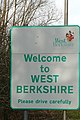 Welcome to West Berkshire - geograph.org.uk - 1186898.jpg 426 × 640; 159 KB
-
 West Berkshire Council composition 2023.svg 360 × 185; 3 KB
-
 West Berkshire Council composition.svg 360 × 185; 3 KB
-
 West Berkshire Council Offices.jpg 3,723 × 2,792; 3.2 MB
-
 West Berkshire UK local election 2015 map.svg 1,425 × 1,124; 542 KB
-
 West Berkshire UK ward map 2019.svg 696 × 432; 356 KB
-
 Woolley Down Barrows - panoramio - ian freeman.jpg 3,072 × 2,304; 3.14 MB
-
 Woolley Down Barrows - panoramio.jpg 3,072 × 2,304; 3.09 MB
.jpg)
.jpg)
.jpg)
.jpg)
.jpg)
.jpg)
.jpg)
.jpg)
.jpg)
.jpg)


.jpg)


.jpg)
.jpg)
.jpg)
.jpg)


.jpg)
.jpg)

.jpg)
.jpg)
.jpg)
.jpg)


.jpg)