File:Église Saint-Gilles de Malestroit Croisée Voûte romane 2.jpg

Size of this preview: 552 × 599 pixels. Other resolutions: 221 × 240 pixels | 442 × 480 pixels | 707 × 768 pixels | 943 × 1,024 pixels | 1,886 × 2,048 pixels | 2,666 × 2,895 pixels.
Original file (2,666 × 2,895 pixels, file size: 1.33 MB, MIME type: image/jpeg)
Captions
Captions
Add a one-line explanation of what this file represents
Summary edit
| Description |
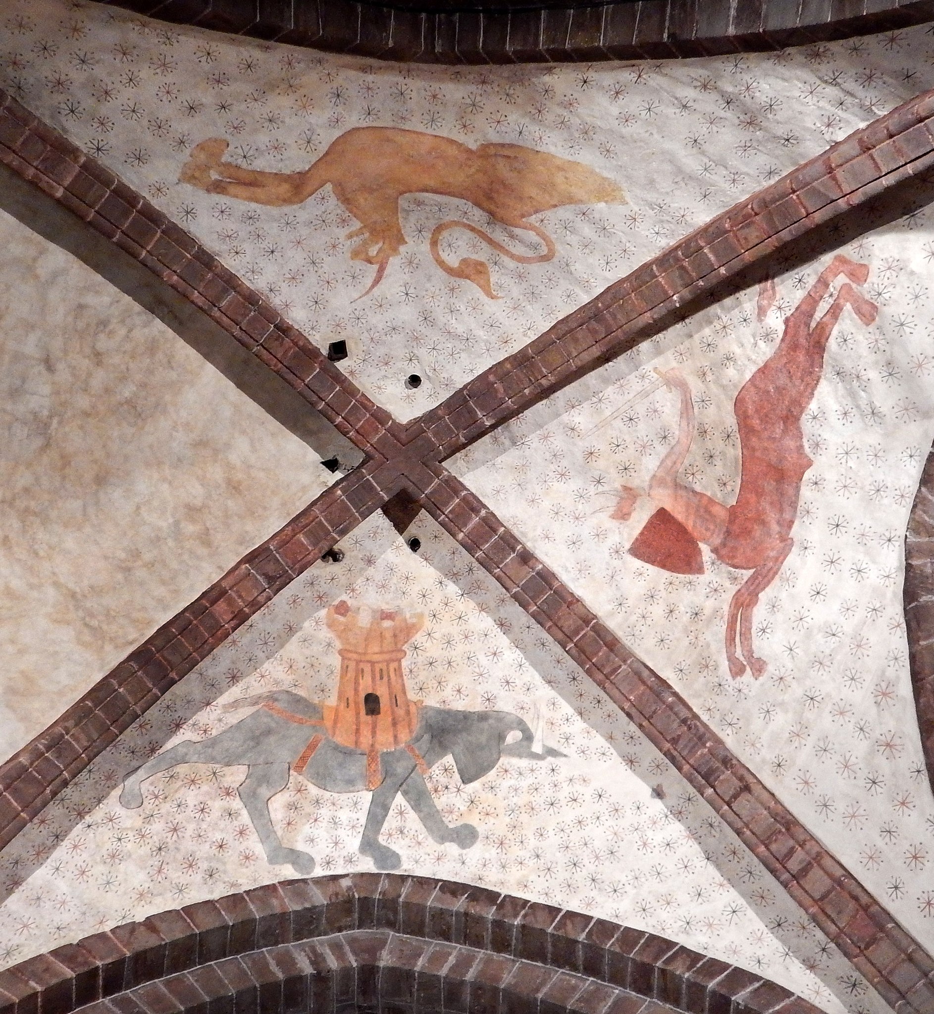
Français : Voûte romane de l'église Saint-Gilles à Malestroit (ici en aout 2016). Cette voute présentait 4 figures animale du bestiaire roman, L'une a disparu, et il reste un éléphant harnaché d'une tour crénelée ; un centaure à deux cornes (figure du diable ?) tenant une épée et un bouclier ; et un félin unicorne. Ces dessins sont peints sur un fond clair constellé de grandes étoiles et organisé de manière à s'inscrire dans un cercle dont la clé de voûte serait le centre. Composition : Les 3 figures sont dessinées en train de courir ou de marcher, ce qui peut donner au spectateur une impression de mouvement circulaire.
English: Roman vault of the Saint-Gilles church in Malestroit (here in August 2016). This vault had 4 animal figures of the roman bestiary, One has disappeared, and there is an elephant caparisoned wiht a crenellated tower; a centaur with two horns (devil figure?) holding a sword and a shield ; and a mono-horned feline. These designs are painted on a light background studded with big stars and organized to be part of a circle whose keystone is the center of the archs. Composition: All 3 figures are drawn running or walking, this can give to the viewer an impression of circular and dynamic motion. |
| Date | |
| Source | Own work |
| Author | Lamiot |
Église Saint-Gilles de Malestroit
|
This building is classé au titre des monuments historiques de la France. It is indexed in the base Mérimée, a database of architectural heritage maintained by the French Ministry of Culture, under the reference PA00091420
|
| Object location | | View this and other nearby images on: OpenStreetMap |
|---|
Licensing edit
I, the copyright holder of this work, hereby publish it under the following license:
This file is licensed under the Creative Commons Attribution-Share Alike 4.0 International license.
- You are free:
- to share – to copy, distribute and transmit the work
- to remix – to adapt the work
- Under the following conditions:
- attribution – You must give appropriate credit, provide a link to the license, and indicate if changes were made. You may do so in any reasonable manner, but not in any way that suggests the licensor endorses you or your use.
- share alike – If you remix, transform, or build upon the material, you must distribute your contributions under the same or compatible license as the original.
File history
Click on a date/time to view the file as it appeared at that time.
| Date/Time | Thumbnail | Dimensions | User | Comment | |
|---|---|---|---|---|---|
| current | 21:47, 19 August 2016 | | 2,666 × 2,895 (1.33 MB) | Lamiot (talk | contribs) | User created page with UploadWizard |
You cannot overwrite this file.
File usage on Commons
There are no pages that use this file.
File usage on other wikis
The following other wikis use this file:
- Usage on fr.wikipedia.org