File:200 BLOCK OF FRONT STREET, BETWEEN DOCK AND MISSION - Front Street (Commercial Buildings), 200-300 Blocks, Ketchikan, Ketchikan Gateway Borough, AK HABS AK,10-KECH,2-2.tif

Size of this JPG preview of this TIF file: 752 × 599 pixels. Other resolutions: 301 × 240 pixels | 602 × 480 pixels | 963 × 768 pixels | 1,280 × 1,020 pixels | 2,560 × 2,041 pixels | 5,000 × 3,986 pixels.
Original file (5,000 × 3,986 pixels, file size: 19.01 MB, MIME type: image/tiff)
Captions
Captions
Add a one-line explanation of what this file represents
Summary edit
| 200 BLOCK OF FRONT STREET, BETWEEN DOCK AND MISSION - Front Street (Commercial Buildings), 200-300 Blocks, Ketchikan, Ketchikan Gateway Borough, AK | ||||
|---|---|---|---|---|
| Photographer |
Related names:
|
|||
| Title |
200 BLOCK OF FRONT STREET, BETWEEN DOCK AND MISSION - Front Street (Commercial Buildings), 200-300 Blocks, Ketchikan, Ketchikan Gateway Borough, AK |
|||
| Depicted place | Alaska; Ketchikan Gateway Borough; Ketchikan | |||
| Date | Documentation compiled after 1933 | |||
| Medium | 4 x 5 in. | |||
| Current location |
Library of Congress Prints and Photographs Division Washington, D.C. 20540 USA http://hdl.loc.gov/loc.pnp/pp.print |
|||
| Accession number |
HABS AK,10-KECH,2-2 |
|||
| Credit line |
|
|||
| Notes |
|
|||
| Source | https://www.loc.gov/pictures/item/ak0349.photos.033075p | |||
| Permission (Reusing this file) |
|
|||

| Object location | | View this and other nearby images on: OpenStreetMap |
|---|
File history
Click on a date/time to view the file as it appeared at that time.
| Date/Time | Thumbnail | Dimensions | User | Comment | |
|---|---|---|---|---|---|
| current | 18:19, 25 June 2014 | 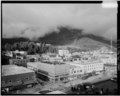 | 5,000 × 3,986 (19.01 MB) | Fæ (talk | contribs) | GWToolset: Creating mediafile for Fæ. HABS batch upload start 25 June 2014 |
You cannot overwrite this file.
File usage on Commons
The following page uses this file: