File:3-4 VIEW FROM SOUTH. - Charleroi-Monessen Bridge, Spanning Monongahela River at State Route 2018, North Charleroi, Washington County, PA HAER PA,63-NOCHA,1-4.tif

Size of this JPG preview of this TIF file: 759 × 599 pixels. Other resolutions: 304 × 240 pixels | 608 × 480 pixels | 973 × 768 pixels | 1,280 × 1,011 pixels | 2,560 × 2,022 pixels | 5,000 × 3,949 pixels.
Original file (5,000 × 3,949 pixels, file size: 18.83 MB, MIME type: image/tiff)
Captions
Captions
Add a one-line explanation of what this file represents
| 3-4 VIEW FROM SOUTH. - Charleroi-Monessen Bridge, Spanning Monongahela River at State Route 2018, North Charleroi, Washington County, PA | ||||
|---|---|---|---|---|
| Photographer |
Eliott, Joseph |
|||
| Title |
3-4 VIEW FROM SOUTH. - Charleroi-Monessen Bridge, Spanning Monongahela River at State Route 2018, North Charleroi, Washington County, PA |
|||
| Description |
Mercantile Bridge Company; Swensson, Emil; American Bridge Company; DeLony, Eric N, project manager; Pennsylvania Department of Transportation, sponsor; Pennsylvania Historical and Museum Commission, sponsor; Elliott, Joseph E, B, photographer |
|||
| Depicted place | Pennsylvania; Washington County; North Charleroi | |||
| Date | 1997 | |||
| Dimensions | 4 x 5 in. | |||
| Current location |
Library of Congress Prints and Photographs Division Washington, D.C. 20540 USA http://hdl.loc.gov/loc.pnp/pp.print |
|||
| Accession number |
HAER PA,63-NOCHA,1-4 |
|||
| Credit line |
|
|||
| Notes |
|
|||
| References |
|
|||
| Source | https://www.loc.gov/pictures/item/pa3586.photos.361205p | |||
| Permission (Reusing this file) |
|
|||

| Object location | | View this and other nearby images on: OpenStreetMap |
|---|
File history
Click on a date/time to view the file as it appeared at that time.
| Date/Time | Thumbnail | Dimensions | User | Comment | |
|---|---|---|---|---|---|
| current | 03:59, 1 August 2014 | 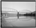 | 5,000 × 3,949 (18.83 MB) | Fæ (talk | contribs) | GWToolset: Creating mediafile for Fæ. HABS 31 July 2014 (3000:3200) |
You cannot overwrite this file.
File usage on Commons
The following page uses this file: