File:824-840 SECOND AVENUE GENERAL VIEW - United Nations Vicinity Area Study, Second Avenue, East Forty-first, East Forty-third, East Forty-fourth, East Forty-eighty, and East Forty HABS NY,31-NEYO,152-4.tif
Size of this JPG preview of this TIF file: 791 × 600 pixels. Other resolutions: 317 × 240 pixels | 633 × 480 pixels | 1,013 × 768 pixels | 1,280 × 970 pixels | 2,560 × 1,940 pixels | 5,000 × 3,790 pixels.
Original file (5,000 × 3,790 pixels, file size: 18.07 MB, MIME type: image/tiff)
Captions
Captions
Add a one-line explanation of what this file represents
Summary edit
| 824-840 SECOND AVENUE GENERAL VIEW - United Nations Vicinity Area Study, Second Avenue, East Forty-first, East Forty-third, East Forty-fourth, East Forty-eighty, and East Forty-ninth Streets, New York, New York County, NY | ||||
|---|---|---|---|---|
| Title |
824-840 SECOND AVENUE GENERAL VIEW - United Nations Vicinity Area Study, Second Avenue, East Forty-first, East Forty-third, East Forty-fourth, East Forty-eighty, and East Forty-ninth Streets, New York, New York County, NY |
|||
| Depicted place | New York; New York County; New York | |||
| Date | Documentation compiled after 1933 | |||
| Dimensions | 4 x 5 in. | |||
| Current location |
Library of Congress Prints and Photographs Division Washington, D.C. 20540 USA http://hdl.loc.gov/loc.pnp/pp.print |
|||
| Accession number |
HABS NY,31-NEYO,152-4 |
|||
| Credit line |
|
|||
| Notes |
|
|||
| Source | https://www.loc.gov/pictures/item/ny1182.photos.118938p | |||
| Permission (Reusing this file) |
|
|||

| Object location | | View this and other nearby images on: OpenStreetMap |
|---|
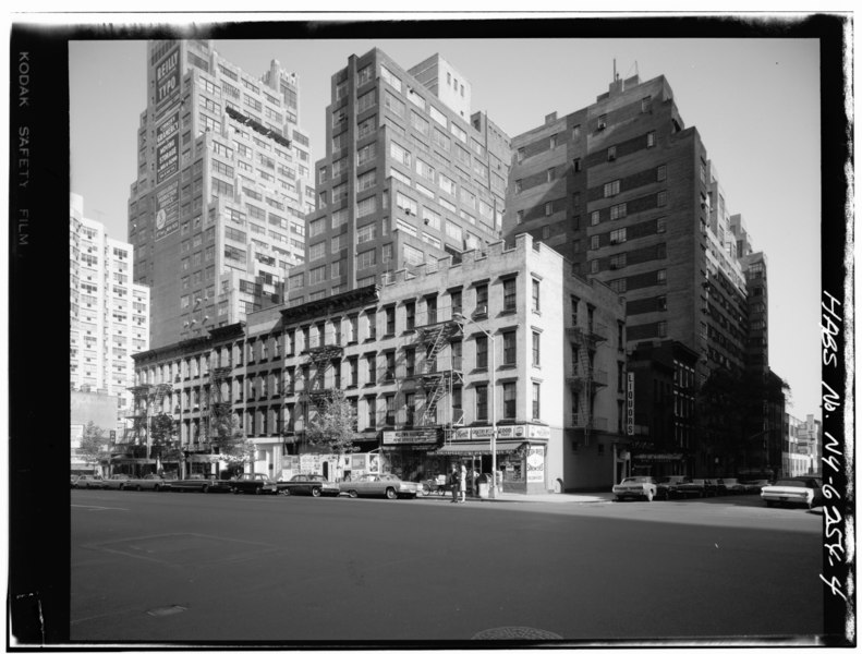
English: This is the east side of Second Avenue in Manhattan between E 44th and E 45th Streets. It probably dates from the 1960s, and cannot be earlier from 1958 because of the poster to re-elect Arthur Levitt.
| Annotations | This image is annotated: View the annotations at Commons |
File history
Click on a date/time to view the file as it appeared at that time.
| Date/Time | Thumbnail | Dimensions | User | Comment | |
|---|---|---|---|---|---|
| current | 14:48, 29 July 2014 |  | 5,000 × 3,790 (18.07 MB) | Fæ (talk | contribs) | GWToolset: Creating mediafile for Fæ. HABS 24 July 2014 (2301:2600) |
You cannot overwrite this file.
File usage on Commons
The following page uses this file: