File:AERIAL VIEW, LOOKING NNW. NOTE SERVICE BUILDING RAMP ENTRANCE AT CENTER OF FRAME. - Chicago Skyway Toll Bridge, Toll Plaza and Service Building, 8801 South Anthony Avenue, HAER ILL, 16-CHIG, 138A-1.tif
Size of this JPG preview of this TIF file: 472 × 599 pixels. Other resolutions: 189 × 240 pixels | 378 × 480 pixels | 605 × 768 pixels | 806 × 1,024 pixels | 1,612 × 2,048 pixels | 3,937 × 5,000 pixels.
Original file (3,937 × 5,000 pixels, file size: 18.78 MB, MIME type: image/tiff)
Captions
Captions
Add a one-line explanation of what this file represents
Summary edit
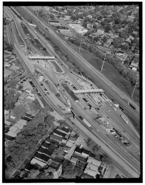
| AERIAL VIEW, LOOKING NNW. NOTE SERVICE BUILDING RAMP ENTRANCE AT CENTER OF FRAME. - Chicago Skyway Toll Bridge, Toll Plaza and Service Building, 8801 South Anthony Avenue, Chicago, Cook County, IL | ||||
|---|---|---|---|---|
| Photographer |
Lowe, Jet |
|||
| Title |
AERIAL VIEW, LOOKING NNW. NOTE SERVICE BUILDING RAMP ENTRANCE AT CENTER OF FRAME. - Chicago Skyway Toll Bridge, Toll Plaza and Service Building, 8801 South Anthony Avenue, Chicago, Cook County, IL |
|||
| Description |
Chicago Department of Public Works; Consoer, Townsend and Associates; Egger Iron Company; Kenny Construction Company; Aurora Pump Company; Bell and Gossett; Cook, Arteluar; DeLony, Eric N, project manager; Chicago Department of Transportation, sponsor; Daley, Richard M, sponsor; Walker, Thomas R, sponsor; Kaderbek, S L, sponsor; Spivey, Justin M, historian; Lowe, Jet, photographer |
|||
| Depicted place | Illinois; Cook County; Chicago | |||
| Date | Documentation compiled after 1968; 1999 | |||
| Dimensions | 4 x 5 in. | |||
| Current location |
Library of Congress Prints and Photographs Division Washington, D.C. 20540 USA http://hdl.loc.gov/loc.pnp/pp.print |
|||
| Accession number |
HAER ILL, 16-CHIG, 138A-1 |
|||
| Credit line |
|
|||
| Notes |
|
|||
| Source | https://www.loc.gov/pictures/item/il0825.photos.318317p | |||
| Permission (Reusing this file) |
|
|||

| Object location | | View this and other nearby images on: OpenStreetMap |
|---|
File history
Click on a date/time to view the file as it appeared at that time.
| Date/Time | Thumbnail | Dimensions | User | Comment | |
|---|---|---|---|---|---|
| current | 14:52, 17 July 2014 |  | 3,937 × 5,000 (18.78 MB) | Fæ (talk | contribs) | GWToolset: Creating mediafile for Fæ. HABS 16 July 2014 (1201:1400) |
You cannot overwrite this file.
File usage on Commons
The following page uses this file: