File:AGHRC (1890) - Carta XV - Territorios de Colombia entre 1843 y 1886.jpg
Size of this preview: 745 × 600 pixels. Other resolutions: 298 × 240 pixels | 596 × 480 pixels | 954 × 768 pixels | 1,272 × 1,024 pixels | 2,544 × 2,048 pixels | 4,285 × 3,450 pixels.
Original file (4,285 × 3,450 pixels, file size: 5.67 MB, MIME type: image/jpeg)
Captions
Captions
Add a one-line explanation of what this file represents
Summary edit
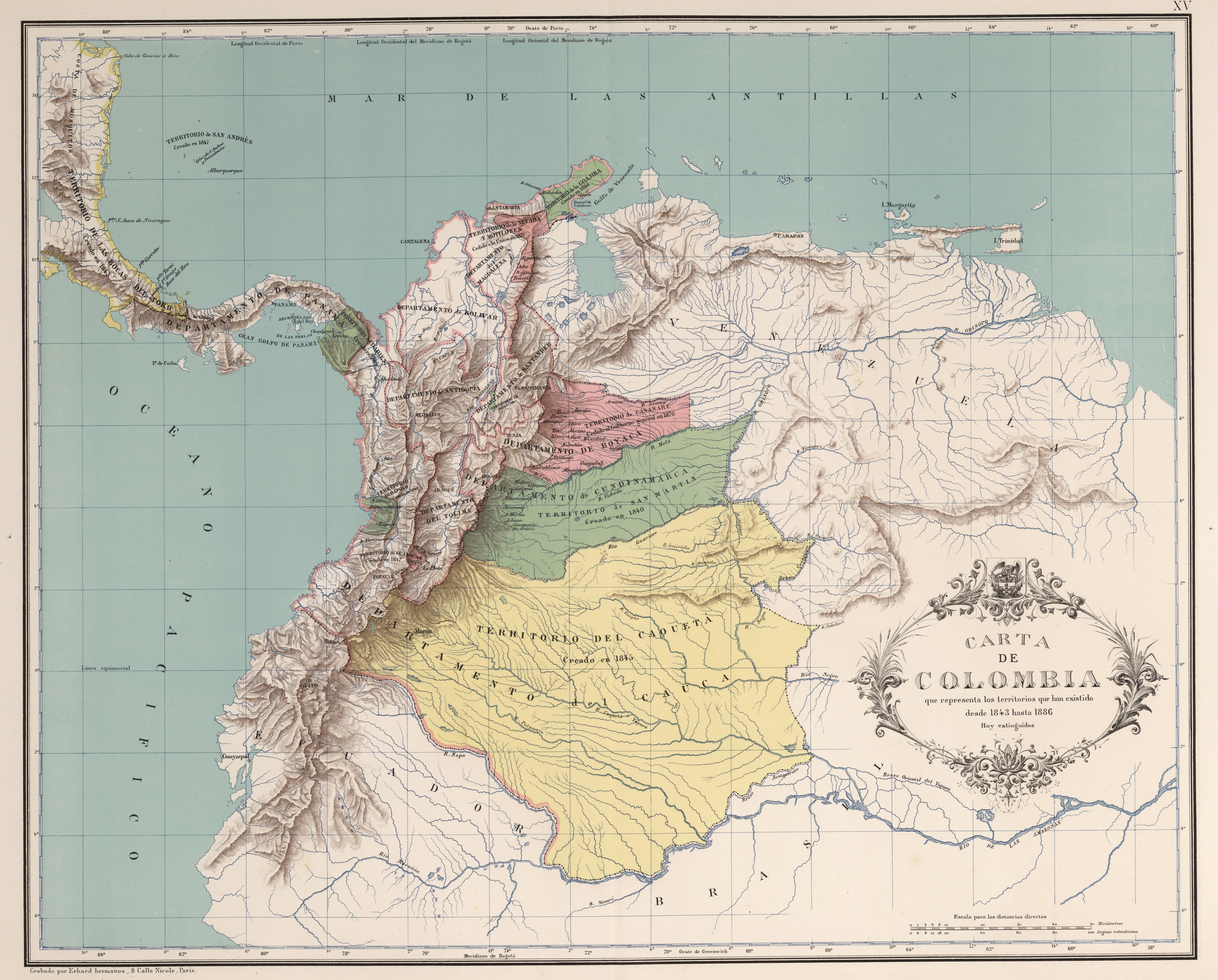
| Description |
Español: Carta que representa los territorios existentes entre 1843 y 1886. Carta XV del Atlas geográfico e histórico de la República de Colombia, 1890. |
||||||||||||||||||||
| Date | |||||||||||||||||||||
| Source | Atlas geográfico e histórico de la República de Colombia, 1890. | ||||||||||||||||||||
| Author |
|
||||||||||||||||||||

_-_Carta_XIV_-_Orograf%C3%ADa_e_hidrograf%C3%ADa_de_Colombia.jpg)
_-_Carta_XVI_-_Corte_geol%C3%B3gico_de_Colombia.jpg)
_-_Carta_XV_-_Territorios_de_Colombia_entre_1843_y_1886.jpg&action=edit§ion=1)
Licensing edit
_-_Carta_XV_-_Territorios_de_Colombia_entre_1843_y_1886.jpg&action=edit§ion=2)
This file is in the public domain because the copyright of this work, registered in Colombia, has expired, according to “Law 23 of 1982 on Copyright, Articles 11, 21-29”, amended by “Law 44 of 1993, Article 2” and “Law 1520 of 2012, Articles 4, 6 and 10” (details). However, some restrictions have to be addressed:
|

|
File history
Click on a date/time to view the file as it appeared at that time.
| Date/Time | Thumbnail | Dimensions | User | Comment | |
|---|---|---|---|---|---|
| current | 13:57, 28 November 2018 | | 4,285 × 3,450 (5.67 MB) | Milenioscuro (talk | contribs) | high quality (from David Rumsey) |
| 01:42, 2 September 2010 |  | 2,815 × 2,316 (2.62 MB) | Milenioscuro (talk | contribs) | {{Information |Description={{es|1=Carta que representa los territorios existentes entre 1843 y 1886. Tomado del "Atlas geográfico e histórico de la República de Colombia", 1890.}} |Source=Atlas geográfico e histórico de la República de Colombia, 189 |
You cannot overwrite this file.
File usage on Commons
The following 3 pages use this file:
_-_Carta_XV_-_Territorios_de_Colombia_entre_1843_y_1886.jpg&redirect=no)
File usage on other wikis
The following other wikis use this file:
- Usage on fr.wikipedia.org
- État souverain du Panama
- État souverain de Bolívar
- État souverain d'Antioquia
- Modèle:Palette Subdivisions des États-Unis de Colombie
- État souverain de Santander
- État souverain de Tolima
- État souverain de Cauca
- État souverain de Boyacá
- État souverain de Cundinamarca
- État souverain de Magdalena
- Territoire national du Caquetá
- Territoire national de San Martín
- Territoire national de La Guajira
- Territoire national du Casanare
- Territoire national de Darién
_-_Carta_XV_-_Territorios_de_Colombia_entre_1843_y_1886.jpg&oldid=842058211)