Milenioscuro
You can leave your comments or suggestions here (in Spanish or English) or on my main account
Milenioscuro
in the Spanish Wikipedia

|
|

Pay attention to licensing
|
Wikimedia Commons only accepts free content: images and other media files that can be used by anyone, for any purpose.
File:Colombia Bogotá location map.png seems to be free (or it would be proposed for deletion), but it was identified as having a wrong license. Usually, it is because a public domain image is tagged with a free license, or because the stated source or other information is not sufficient to prove the selected tag is correct. Please verify that you applied the correct license tag for this file. If you believe this file has the correct license, please explain why on the file discussion page.
|
The reason given by the user who added this tag is: Original license (from OpenStreetMap) may be missing
Pernambuco edit
Good afternoon, Milenioscuro. Initially, I do not speak English, so this message was made with a translator. Regarding the image, I know that it gave that problem with the coordinates, but it had loaded that new version because, first of all, the micro and mesoregions were extinct and yet the microregion lines were superimposed and still visible on the map. Note that in the new version that had loaded they no longer appear. Secondly, I find it unnecessary to show the south of Rio Grande do Norte state on that map. Another reason is that some counties were with the outdated division, for example, Terra Nova. One more reason: the division between Pernambuco and Ceará had a change, according IBGE. I also did not understand why the colors did not conform to the conventions. As I do not like to get into edit war, I thought it best to come here to your discussion page to reach some consensus. I await an answer. Marquinhos talk 16:00, 29 March 2019 (UTC)
- @Marcos Elias de Oliveira Júnior: Hola Marquinhos. Puede hablar portugués con confianza, yo entiendo un poco y lo que no, pues lo traduzco con el traductor. Hubiera preferido que antes de subir el archivo se comunicara conmigo, para saber que hacer y que modificar. Usted tiene razón en varias cosas, por ejemplo el tamaño del mapa (que muestra zonas sin información útil) y la desactualización de las divisiones municipales. Con respecto a eso, apenas me entero de que las micro y macrorregiones dejaron de existir, quizás eso implique que en los demás mapas también deban quitarse. Y bueno, si, los mapas tipo location tienen unas convenciones que se usan desde el 2008, para mantener una uniformidad constante entre los mapas; pueden verse aquí o aquí.
- Hoy o mañana hago las modificaciones pertinentes en el mapa ya con los arreglos mencionados por usted y por mi, que pase buena tarde. --Milenioscuro (talk) 19:02, 29 March 2019 (UTC)
- @Milenioscuro: obrigado pela resposta. Utilizei este esquema de cores mostrado nos últimos mapas que carreguei. Marquinhos talk 19:15, 30 March 2019 (UTC)
![]() Answered
Answered
Request edit
.svg)
Can you make the maps for the divisions of Balochistan, Sindh, Khyber Pakhtunkhwa, Azad Kashmir and Gilgit Baltistan as you did this for Amritsar and many other districts of India (shown below):
I requested you for this because these divisions have no proper and true maps on commons. I can give you the list of these divisions in a short way if you agreed and needed. I hope you will pay attention to my request. Thanks! DdBbCc22 (talk) 16:52, 17 April 2019 (UTC)
- @DdBbCc22: I have a couple of queued requests, but yes, I could make them. --Milenioscuro (talk) 19:45, 17 April 2019 (UTC)
@Milenioscuro: If not yet, after a while. Any time period if possible? They are total approximately 25 maps. DdBbCc22 (talk) 01:02, 18 April 2019 (UTC)
- @DdBbCc22: Hi, I'm starting to make your request, but I have a doubt with the old "Tribal Areas", ¿were they divided into divisions or were they a single unit? and the same goes for Azad Kashmir. I can not find maps online to clarify the situation. --Milenioscuro (talk) 14:18, 9 May 2019 (UTC)
![]() Done
Done
Tocantins edit
Hola, Milenioscuro. Por favor, puede verificar el mapa de dos ciudades del estado de Tocantins en Brasil? Xambioá y Piraquê están con sus mapas divergentes de Google Maps. Gracias por su atención. --Harly~commonswiki (talk) 12:01, 21 May 2019 (UTC)
- @Harly~commonswiki: en ese caso debería hablar con el usuario Raphael.lorenzeto quien fue el que hizo los mapas de esos municipios. --Milenioscuro (talk) 13:27, 21 May 2019 (UTC)
![]() Answered
Answered
Distrito de Barrancabermeja edit
.svg)
¡Hola! Pues eso, que ahora resulta que Barrancabermeja es un distrito Alguien editó Municipios de Colombia y resultó ser cierto. Por si tienes tiempo de editar la imagen de la derecha (y similares). Un abrazo, --·×ald·es 20:05, 28 June 2019 (UTC)
![]() Done
Done
Community Insights Survey edit
Share your experience in this survey
Hi Milenioscuro,
The Wikimedia Foundation is asking for your feedback in a survey about your experience with Wikimedia Commons and Wikimedia. The purpose of this survey is to learn how well the Foundation is supporting your work on wiki and how we can change or improve things in the future. The opinions you share will directly affect the current and future work of the Wikimedia Foundation.
Please take 15 to 25 minutes to give your feedback through this survey. It is available in various languages.
This survey is hosted by a third-party and governed by this privacy statement (in English).
Find more information about this project. Email us if you have any questions, or if you don't want to receive future messages about taking this survey.
Sincerely,
Reminder: Community Insights Survey edit
Share your experience in this survey
Hi Milenioscuro,
A couple of weeks ago, we invited you to take the Community Insights Survey. It is the Wikimedia Foundation’s annual survey of our global communities. We want to learn how well we support your work on wiki. We are 10% towards our goal for participation. If you have not already taken the survey, you can help us reach our goal! Your voice matters to us.
Please take 15 to 25 minutes to give your feedback through this survey. It is available in various languages.
This survey is hosted by a third-party and governed by this privacy statement (in English).
Find more information about this project. Email us if you have any questions, or if you don't want to receive future messages about taking this survey.
Sincerely,
Corregir mapa de límites entre Venezuela y Colombia edit
Muy buenas tardes Milenioscuro.
Le pido el favor de corregir el siguiente mapa:

La razón es que ni Colombia ni Venezuela han definido sus límites marítimos. Aunque sí lo hicieron con los límites del territorio continental con el Tratado de 1941, el Archipiélago de Los Monjes sigue siendo una zona en disputa entre ambos países, y usted ubicó a dichas islas en el lado venezolano.
Le pido el favor de eliminar la línea divisoria en el mar entre estos dos países y poner que es un territorio en disputa. Muchas gracias por su atención. Saludos.
--Debray05 (talk) 18:34, 23 September 2019 (UTC)
![]() Done
Done
Reminder: Community Insights Survey edit
Share your experience in this survey
Hi Milenioscuro,
There are only a few weeks left to take the Community Insights Survey! We are 30% towards our goal for participation. If you have not already taken the survey, you can help us reach our goal! With this poll, the Wikimedia Foundation gathers feedback on how well we support your work on wiki. It only takes 15-25 minutes to complete, and it has a direct impact on the support we provide.
Please take 15 to 25 minutes to give your feedback through this survey. It is available in various languages.
This survey is hosted by a third-party and governed by this privacy statement (in English).
Find more information about this project. Email us if you have any questions, or if you don't want to receive future messages about taking this survey.
Sincerely,
File:Brazil Rondonia location map.svg edit

Hello, Milenioscuro. There are some errors on this map and on its derived maps. The errors are on the cities of Costa Marques, São Francisco do Guaporé, Seringueiras, São Miguel do Guaporé and Nova Brasilândia d'Oeste. I tried to fix them, but I don't have your skills. 'XD Can you fix them? Att Bielrugero (talk) 19:48, 11 October 2019 (UTC)
PS: There's a Brazilian institute called IBGE, a database of all states and municipalities in Brazil, includind maps. The link of Costa Marques city is this. If you use the search box, you'll find maps of all cities. It's in Portuguese, but you'll be able to understand.
- @Bielrugero:
 Done, sin embargo dos cosas:
- El mapa que realicé es un derivado de uno que ya existía en commons, no es el "original" por decirlo de alguna manera.
- No voy a actualizar ningún otro mapa.
Important message for file movers edit

A community discussion has been closed where the consensus was to grant all file movers the suppressredirect user right. This will allow file movers to not leave behind a redirect when moving files and instead automatically have the original file name deleted. Policy never requires you to suppress the redirect, suppression of redirects is entirely optional.
Possible acceptable uses of this ability:
- To move recently uploaded files with an obvious error in the file name where that error would not be a reasonable redirect. For example: moving "Sheep in a tree.jpg" to "Squirrel in a tree.jpg" when the image does in fact depict a squirrel.
- To perform file name swaps.
- When the original file name contains vandalism. (File renaming criterion #5)
Please note, this ability should be used only in certain circumstances and only if you are absolutely sure that it is not going to break the display of the file on any project. Redirects should never be suppressed if the file is in use on any project. When in doubt, leave a redirect. If you forget to suppress the redirect in case of file name vandalism or you are not fully certain if the original file name is actually vandalism, leave a redirect and tag the redirect for speedy deletion per G2.
The malicious or reckless breaking of file links via the suppressredirect user right is considered an abuse of the file mover right and is grounds for immediate revocation of that right. This message serves as both a notice that you have this right and as an official warning. Questions regarding this right should be directed to administrators. --Majora (talk) 21:36, 7 November 2019 (UTC)
¡Una Wikiestrella para ti! edit

|
Wikiestrella del trabajador | |
| Por tu gran trayectoria en Wikimedia. ¡Gran trabajo, y continúa así!. Atentamente: David C. S. 22:31, 4 December 2019 (UTC), Puyo - Ecuador. |
¡Una Wikiestrella para ti! edit

|
Wikiestrella del diseñador gráfico | |
| Por tus magníficos trabajos en los campos de la cartografía y la heráldica. ¡Felicitaciones!. Atentamente: David C. S. 22:31, 4 December 2019 (UTC), Puyo - Ecuador. |
Fort Ross edit
Buenos dias ! ¿Sobre este mapa, pueden agregar "Fort Ross" en California (ruso de 1812 a 1841)? Ver [1] Gracias ! --Claude Zygiel (talk) 10:07, 2 February 2020 (UTC)
- @Claude Zygiel: Buen día. En este mapa se incluye todas las posesiones del Impero Ruso, en el mapa ortográfico no es posible pues está centrado en Asia y no permite ver América del Norte más al sur de Canadá. --Milenioscuro (talk) 12:28, 2 February 2020 (UTC)
- Bueno. Hasta luego, --Claude Zygiel (talk) 16:35, 2 February 2020 (UTC)
![]() Answered
Answered
Administrative Division edit
Please DO NOT remove those files from Category:Maps of prefecture-level divisions of China, thanks. Chk2011 (talk) 08:04, 10 February 2020 (UTC)
- @Chk2011: ¿why not? --Milenioscuro (talk) 18:20, 12 February 2020 (UTC)
- @Milenioscuro: it is a good categorization to put similar files in one category. If you put those files just in independent categories one by one with "Maps of xxx", it is weakening the function of category. It is OK to add the category to the files. If you think the name of the category is not precise, please request renaming. e.g. Administrative maps by prefecture-level divisions of China. Make it simple, the original goal to create that category is to put all similar files in one category. Chk2011 (talk) 23:15, 12 February 2020 (UTC)
Actualización: Distritos de la Provincia de Chiriquí edit
Hola Milenioscuro, observé que en el 2017 actualizaste el mapa político-administrativo de la provincia de Chiriquí, al añadir el distrito de Tierras Altas. También actualizaste el distrito anteriormente mencionado y el distrito de Bugaba, del cual fue segregado para crear este distrito. Sin embargo, los mapas de los otros distritos de la provincia no han sido actualizados con el distrito de Tierras Altas. Podrías actualizarlos ya que fuiste el último en actualizar estos archivos. GiankM. M 10:28, 27 February 2020 (UTC)
![]() Done
Done
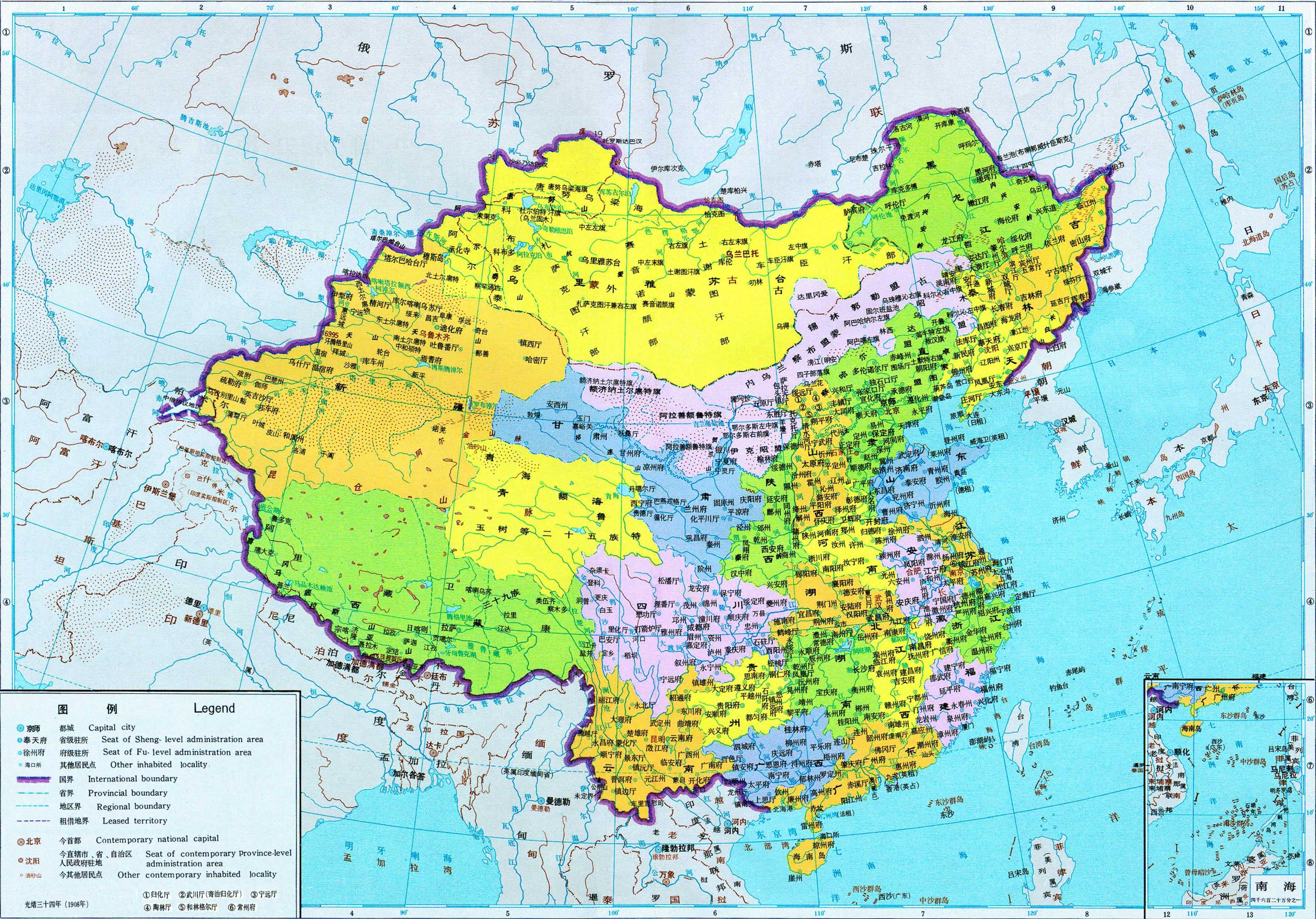
Territorial evolution maps of China edit
China in 1936-49 edit
Hello, thank you very much for the two China maps you made, but there are a few serious problems
In map File:China in 1936.svg, Germany lost Qingdao in Shandong long after the defeat of World War I, and Weihai was returned to China by Britain in 1930. — Preceding unsigned comment was added by 185.177.229.13 (talk) 21:37, 5 March 2020 (UTC)
In map File:China in 1949.svg, although Mongolia was recognized by China in 1946, the boundary between the two countries was not determined. It was not stipulated in the treaty until 1962. the dashed lines should be used as in other regions.
https://zh.m.wikisource.org/zh-hans/中华人民共和国和蒙古人民共和国边界条约 — Preceding unsigned comment was added by 185.177.229.13 (talk) 21:24, 5 March 2020 (UTC)
- The main source of the maps is this page: 透过地图看历史 1949年-1999年中国行政区划的变迁. You can see for yourself the sources in the description of the files, almost all of them shows the border China-Mongolia like in my maps. --Milenioscuro (talk) 02:59, 8 March 2020 (UTC)
![]() Answered
Answered
-
 Mongolia in 1932
 -
 China in 1947


China in 1911.svg edit
这幅地图的边界有很多问题,新疆和云南的最西部并不是按照中华民国初年的官方边界描绘的,多余的部分只是被KMT的国民政府声称,而不是1912~28年的北洋政府,请注意这两个政府声称边界的不同,请予以更正. — Preceding unsigned comment was added by 47.74.222.169 (talk) 05:45, 8 January 2021 (UTC)
Si sabe chino, este artículo puede explicar por qué el mapa de KMT es diferente del mapa de la República de China en 1912. http://history.m4.cn/2015-12/1294849.shtml — Preceding unsigned comment was added by 47.74.222.169 (talk) 05:55, 8 January 2021 (UTC)
-
 China in 1922
 -
 China in 1926
 -
 甚至在国民政府执政的1930s,边界地图,也没有像后来那样夸张


- He aquí la comparativa de dos mapas que hice de 1911, uno de ellos tiene anotaciones que explican los cambios territoriales a principios del siglo XX y el otro en su descripción tiene las fuentes de donde se sacó las fronteras dibujadas. --Milenioscuro (talk) 17:40, 31 May 2021 (UTC)
-
 China, 1911
 -
 China, 1911, con anotaciones


![]() Answered
Answered

Obviamente, todavía hay muchos problemas con el mapa de China en 1911. ¿Se pueden marcar las áreas en disputa con líneas punteadas como File:China in 1936.svg? Los mapas oficiales de la dinastía Qing que puedo buscar no incluyen Yunnan y la parte más occidental de Xinjiang. Los primeros mapas que se pueden encontrar para incluir estas áreas aparecieron en la década de 1930. 1905 年版《大清帝国全图》 Tanqixiang map Qing 1908 Además, la es:línea McMahon no involucra la frontera entre Myanmar y China. El gobierno tibetano no ha gobernado Yunnan antes, El tratado de 1914 solo fue firmado entre los gobiernos británico y tibetano.
- Si, está bien, puedo dibujar las fronteras en líneas punteadas para clarificar que esas zonas estaban en disputa entre China y el Imperio británico. --Milenioscuro (talk) 16:58, 6 June 2021 (UTC)
File:ROC vs PRC.svg requires updating edit
Hi Milenioscuro,
Thank you for your contributions to Commons. I noticed File:ROC vs PRC.svg is out of date. ROC now has three additional municipalities in Taiwan: New Taipei, Taoyuan, and Tainan. Could you update it? Thanks again. Ythlev (talk) 05:19, 10 March 2020 (UTC)
![]() Done
Done
C’ouvi dizer… edit
Não tens mais nada que fazer, é? -- Tuválkin ✉ ✇ 14:34, 18 March 2020 (UTC)
- @Tuvalkin: don't cry dude, you can rename it whenever you want. --Milenioscuro (talk) 19:27, 26 March 2020 (UTC)
![]() Answered
Answered
Re: Objects edit
I am not sure how to fix these objects, so I'm sorry if I got confused. If it was John Q Poppy's version you were editing, then I apologize, as he has several wrongly highlighted counties on his version; I mistook it as you restoring them. Jerome501 (talk) 22:35, 26 March 2020 (UTC)
![]() Answered
Answered
Hello, Milenioscuro,
thank you for your excellent map which is a lot clearer and esthetically pleasing than the grainy gif maps that were used before. However, I am somewhat irritated by both the date and the extent of the cession of Shan States to Britain. You cite David K. Wyatt's A Short History of Thailand (2003) as your source, but in that book I find nothing about a cession to Britain taking place in 1893. According to my information, the British actually took control of the Shan States as early as 1885, after the w:Third Anglo-Burmese War.
The so-called Chinese Shan states in what is now Yunnan, however, were never British. Britain explicitly confirmed their belonging to China in the 1894 border agreement, fixing their border along the Nam Lam river between "Kiang Hung" (Jinghong) that belonged to China and "Kiang Tong" (Kengtung) belonging to Britain, that still is the border between China and Myanmar today. But even before that agreement, Britain had no control over southern Yunnan, which is why these territories were called "Chinese Shan states". The area west of the Mekong was only considered Britain's sphere of influence vis-à-vis France according to the 1896 Upper Mekong agreement, while the eastern bank belonged to the French sphere (thus having territories east of the Mekong shaded in red is quite odd). But that deal does not regard territorial cessions of Siam.
In Wyatt's map of "Thai territorial losses, 1785–1909", the Shan states are not regarded at all (neither the Burmese nor the Chinese ones). Probably because Siam never held actual territorial control over them. The Siamese claim to overlordship over the Shan states was rather of theoretical nature. Perhaps, it would be best to follow Wyatt's example and ignore the Shan states in your map. At least, the year 1893 should be changed to 1885 (which still would be slightly misleading, because Siam did not cede the Shan states to Britain in 1885, as it did not control them anyway; Britain simply took them). And the "Chinese Shan states" should not be included in the British possessions. Kind regards, --RJFF (talk) 12:33, 2 April 2020 (UTC)
![]() Done
Done
Source of derivative work is not properly indicated: File:Iguaçu in Brazil (1943).svg edit
| This file may be deleted. |
A file that you have uploaded to Wikimedia Commons, File:Iguaçu in Brazil (1943).svg, is a derivative work, containing an "image within an image". Examples of such works would include a photograph of a sculpture, a scan of a magazine cover, or a map that has been altered from the original. In each of these cases, the rights of the creator of the original must be considered, as well as those of the creator of the derivative work.
While the description page states who made this derivative work, it currently doesn't specify who created the original work, so the overall copyright status is unclear. If you did not create the original work depicted in this image, you will need to specify the owner of the copyright. Please edit the file description and add the missing information, or the file may be deleted. If you created the original content yourself, enter this information as the source. If someone else created the content, the source should be the address to the web page where you found it, the name and ISBN of the book you scanned it from, or similar. You should also name the author, provide verifiable information to show that the content is in the public domain or has been published under a free license by its author, and add an appropriate template identifying the public domain or licensing status, if you have not already done so. Please add the required information for this and other files you have uploaded before adding more files. If you need assistance, please ask at the help desk. Thank you! |

|
File:Map of the Rattanakosin Kingdom.svg has been listed at Commons:Deletion requests so that the community can discuss whether it should be kept or not. We would appreciate it if you could go to voice your opinion about this at its entry.
If you created this file, please note that the fact that it has been proposed for deletion does not necessarily mean that we do not value your kind contribution. It simply means that one person believes that there is some specific problem with it, such as a copyright issue. Please see Commons:But it's my own work! for a guide on how to address these issues. |
|
|
File:Map of Siam (territorial cessions).svg has been listed at Commons:Deletion requests so that the community can discuss whether it should be kept or not. We would appreciate it if you could go to voice your opinion about this at its entry.
If you created this file, please note that the fact that it has been proposed for deletion does not necessarily mean that we do not value your kind contribution. It simply means that one person believes that there is some specific problem with it, such as a copyright issue. Please see Commons:But it's my own work! for a guide on how to address these issues. |
Hello. Change the upper one (БССР -> ССРБ). And I still saw an inaccuracy. Below the stems are white, must yellow. File:Emblem of the Byelorussian SSR (1920).svg Валко (talk) 04:00, 3 May 2020 (UTC)
Hello, don't change File:Emblem of the Byelorussian SSR (1920).svg, done File:Герб Социалистической Советской Республики Белоруссии.svg Валко (talk) 04:02, 5 May 2020 (UTC)
![]() Not done
Not done
Hi. Change the motto, in the Belarusian language since 1927 it looked like: "Пралятары усiх краiн, злучайцеся!" (before 1927 it was:"Пролетарыi усiх краеу, злучайцеся!") 95.110.103.175 02:02, 31 July 2020 (UTC)
- Compare
-
 original
 -
 svg
svg
.jpg)
.svg)
Валко (talk) 16:13, 6 August 2020 (UTC)
![]() Not done
Not done
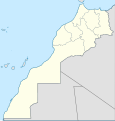
Request Morocco map edit
Hi Milenioscuro, If you have free time. could you make an SVG version of this map? but with the wikipedia map theme, you know something like this: and also maps highlighting each region in the map? thank you.--أنس (talk) 20:18, 18 August 2020 (UTC)
-
 2015 wikipedia themed map
 -
 1971 Done


- @أنس: Done (general map). I dont know the names of the regions, so I dont make the highlighted maps. --Milenioscuro (talk) 21:40, 11 April 2021 (UTC)
Gilgit-Baltistan and Azad Kashmir edit
I noticed that your otherwise excellent location map of the Kashmir region is in need of some updating to show the boundaries of the current 14 districts in Gilgit-Baltistan instead of the previous 10 districts there, and also to show an updated boundary between Gilgit-Baltistan and Azad Kashmir.
https://commons.wikimedia.org/wiki/File:Kashmir_location_map.svg
The following two maps show that updated information.
https://commons.wikimedia.org/wiki/File:Azad_Kashmir_Location_Map.svg
https://commons.wikimedia.org/wiki/File:Pakistan_Gilgit_Baltistan_location_map.svg
|
|
File:Troncal del caribe.svg has been listed at Commons:Deletion requests so that the community can discuss whether it should be kept or not. We would appreciate it if you could go to voice your opinion about this at its entry.
If you created this file, please note that the fact that it has been proposed for deletion does not necessarily mean that we do not value your kind contribution. It simply means that one person believes that there is some specific problem with it, such as a copyright issue. Please see Commons:But it's my own work! for a guide on how to address these issues. |
China provinces map request edit
Hello Milenioscuro
I saw your wonderful maps on this wikipage, and I was wondering if you had all of these same maps but with Japan fully displayed on them, preferably as an SVG file.
If these maps were available, can I have your permission to use them as a template to make maps of my own about the Chinese Warlord Era (1916-1928)? These maps will run from 1911 until at least 1937 and maybe through to 1949.
Thanks in advance,
FatMax1492 (talk) 09:52, 24 October 2020 (UTC)
- @FatMax1492: You can use the maps as you wish, as long as you credit me. All maps contain full Japan (and other territories), if you open them with inkscape you can see them. --Milenioscuro (talk) 19:52, 11 April 2021 (UTC)
- @Milenioscuro: Thanks for your response! I tried opening them with GIMP before, but it didn't show full Japan. I'll try Inkscape and check if full Japan is on there. FatMax1492 (talk) 07:32, 12 April 2021 (UTC)
![]() Answered
Answered
Pakistani provinces edit
Your maps on Pakistani provinces have been great. I am trying to create accurate relief maps for these provinces, and so I need to know their coordinates to get the right data. However, it seems that the coordinates listed on the Modules pages for some of these provinces (Punjab, Balochistan and Khyber Pakhtunwa for instance) are not accurate since there is a significant difference between the topographic maps I extracted from those coordinates and the location maps. Can you give me the bounds for all maps of the provinces of Pakistan you have made: Here, Here, and Here? Thanks. C1MM (talk) 02:50, 25 October 2020 (UTC)
- @C1MM: Hello. These maps have coordinates taken from Google Earth manually, maybe that's why they don't coincide with the real ones. --Milenioscuro (talk) 06:17, 28 November 2020 (UTC)
- Thanks, I was wondering if it would be possible to either extract new location maps using the coordinates listed on the location map modules (using the same datasource as you) or accurately determine the coordinates of the current locator maps (to like 2 or 3 decimal places). C1MM (talk) 18:48, 28 November 2020 (UTC)
![]() Answered
Answered
How to make maps edit
hello good afternoon I would like to ask how you create the maps like the maps of the new spain I would appreciate it very much pd:my english is very bad therefore i am using a translator Fernando Sshostakovich (talk) 22:13, 29 October 2020 (UTC)
Turkestan 109.187.65.115 04:42, 15 November 2020 (UTC)
![]() Not done
Not done
A well overdue barnstar edit

|
The Graphic Designer's Barnstar | .svg)
|
| I have discovered your amazing map showing the maritime borders in the Caribbean. You well deserve this award for the quality of your map, as well as the huge amount of work that went into it. Mapeh (talk) 09:42, 20 January 2021 (UTC) |
Mistake in Russian map edit
Hello,
On this map of yours (File:Expansión territorial de Rusia.svg), you incorrectly portrayed Kiev as falling under Russian rule in 1772. However, the Wikipedia article for Kiev says that it fell under Russian rule in 1667. In fact, some of the maps that you used as sources for your own map likewise show Kiev as falling under Russian rule in the late 1600s. Thus, I was wondering if you would be willing to fix this error on your map.
Have a good day and best regards,
Futurist110 (talk) 04:46, 2 January 2019 (UTC)
- I’m sorry, but your map (File:Expansión territorial de Rusia.svg) has mistake: territory that marked like 1772 was Russian in 1654 , and part of territory what marked like 1793 was Russian in 1772. Also you in dessignation modern borders gave to Latvia and Estonia the western part of Pskov Oblast and Leningrad Oblast. Thank you. NikitFillipov (talk) 14:54, 5 February 2021 (UTC)
- I’m sorry, but your map: File:Expansión territorial de Rusia.svg has mistake: territory that marked like 1772 was Russian in 1654 , and part of territory what marked like 1793 was Russian in 1772. Also you modern territory (western part of Pskov Oblast and Leningrad Oblast) gave to Latvia and Estonia. Correct this please Thank you.
- Lo siento, pero su mapa: File:Expansión territorial de Rusia.svg se equivoca: el territorio que marcaba como 1772 era ruso en 1654, y parte del territorio que marcaba como 1793 era ruso en 1772. También usted el territorio moderno (la parte occidental del Óblast de Pskov y el Óblast de Leningrado) dio a Letonia y Estonia. Corrija esto por favor, gracias. — Preceding unsigned comment was added by 95.221.116.240 (talk) 05:28, 13 March 2021 (UTC)
![]() Not done
Not done
Mapa del Magdalena Medio edit

— Preceding unsigned comment was added by 2803:2A80:F0:CB99:41F5:1DDB:F0BA:35C4 (talk) 04:35, 10 February 2021 (UTC)
¡Hola! Resulta que aparece municipios principalmente de los Departamentos de Bolívar (Achí, San Jacinto del Cauca, Pinillos, Montecristo, Tiquisio, San Martin de Loba, Barranco de Loba, Altos del Rosario, Hatillo de Loba, San Fernando, Margarita, El Peñón) y Cesar (Chimichagua, Curumaní, Pailitas, Tamalameque, Pelaya, Rio de Oro, González), Además, del El Banco, Magdalena que no son parte del esta Subregión y tiene ese error en la siguiente imagen: [[2]]. Espero que con tiempo puedas editar la imagen pronto. Un saludo, --·User:Henblo 21:41, 09 Feb 2020 (UTC)
![]() Not done
Not done
Historical World Maps edit
Guess I have mentioned that earlier: I had de:Benutzer:Antemister/Weltkarten, a project of creating a series of historical world maps. But it dropped off later , as the my counterparts lacks the time to continue. But over the last months I had t learn programming and developed a small tool similar to [3] that is based on that map series. Question: Would you have, in principle, interest in continuing this series, as a long-term project?--Antemister (talk) 22:46, 3 March 2021 (UTC)
can you make dalian the correct size in "Japanese Empire (orthographic image)"? edit
dont remove it, but just make it the correct size, because its way bigger than it actually was. — Preceding unsigned comment was added by 2804:14D:4489:13DF:7863:5C17:D63E:3821 (talk) 14:52, 7 March 2021 (UTC)
and also, color azad hindi territory in India. 2804:14D:4489:13DF:7863:5C17:D63E:3821 14:53, 7 March 2021 (UTC)
- Done. --Milenioscuro (talk) 02:31, 18 April 2021 (UTC)
Good day! I'd like to say smth:
1. Maps: map1, map2, map3, map4, map5, map6. I suggest to enlarge the area on this map in light green the zone of influence of Russia in Armenia (territory of Turkey) in accordance with the above maps and in this map too.
Thank you! Good luck and thank you for your work--NikolayLukas (talk) 14:47, 4 April 2021 (UTC)
![]() Not done
Not done
Request Somaliland edit
-
 Map of the administrative regions of Somaliland.
 -
 Somaliland location map.

.svg)
Article(s): en:Regions of Somaliland, Category:SVG locator maps of regions of Somaliland
- Hi @Milenioscuro: , I saw your great work making Location maps and i would to like request you.
- Could please draw Location maps of Somaliland with regional borders.
- Like this!
 Many Thanks.-- --Siirski (talk) 17:35, 15 April 2021 (UTC)
- Like this!
- Could please draw Location maps of Somaliland with regional borders.

- @Siirski: Done, you can find them here. --Milenioscuro (talk) 15:52, 16 April 2021 (UTC)
- Hi @Milenioscuro: , Thank you much for great work of location maps of Somaliland regions
Flag of Nicoya edit
Hello. In 2013 you uploaded File:Bandera de Nicoya.svg. The problem is that this is a fictional flag. It comes from this alternate history project. The real flag of Nicoya is a green and red bicolor. You can see it on the municipal website, in this photo in front of a church, and on Flags of the World. If I knew how to make vector images, I would upload a new version myself. (A new version of the file is appropriate here, correct? Since the current version is a fiction and appears on more than 30 Wikipedia pages.) But I feel like making a version of the correct file should be fairly simple, and it really should be replaced. Thanks, Fishal (talk) 22:33, 5 May 2021 (UTC)
- @Fishal: Entendido. Cuando creé la imagen la bandera que mostraban en FOTW era esa, pero veo que ya corrigieron, proceso a hacerlo mismo. --Milenioscuro (talk) 20:51, 6 May 2021 (UTC)
- Sí, también miré esa bandera ficticia en una vieja versión de FOTW. Fishal (talk) 23:56, 6 May 2021 (UTC)
- Done. --Milenioscuro (talk) 19:08, 1 June 2021 (UTC)
Maps of Venezuelan provinces edit
Hello, it's me again
I was wondering, over on this wikipage there's your maps of the provinces of Venezuela over the years.
On the 1810 map there's a relatively big Barinas, reaching almost all the way to Barquisimeto. Cumaná is also doesn't reach the Orinoco Delta
On this map of Venezuela in 1810, you can see Barinas is smaller, and Cumaná is bigger. This map was made in ~1890 in Colombia, as part of the Geographical and Historical Atlas of the Republic of Colombia
Do you have an idea on why those maps differ?
FatMax1492 (talk) 17:20, 11 May 2021 (UTC)
- @FatMax1492: hola, voy a responder en español porque es mi idioma natal y me es mas fácil expresar los cambios entre mapas en mi propio lenguaje.
- El mapa en cuestión pertenece al Atlas Físico y Político de la República de Venezuela, pero este es un mapa general y contiene ciertos errores del autor. En 1810 (y desde antes) el delta del río Orinoco pertenecía a la provincia de Guayana como parte del cantón Piacoa. En ese mismo año la provincia de Barinas estaba compuesta por los actuales estados venezolanos de Barinas, Portuguesa y Apure, cuando se conformó la Gran Colombia (1819-1821) se segregó Apure para crear una provincia del mismo nombre. mas tarde en la década de 1850 se segregó Portuguesa y se creó la provincia homónima.
- La evolución de los cambios territoriales de las provincias de Venezuela (ahora estados) se puede verificar en el artículo Provincias de Venezuela de la wikipedia en español.
- Saludos.--Milenioscuro (talk) 18:52, 11 May 2021 (UTC)
- Corrijo lo dicho respecto a Barinas, buscando sobre la división política de la provincia de Caracas en 1811 encontré este archivo, que en su página 56 dice lo siguiente:
- De todas las provincias que conformaban la antigua Capitanía General de Venezuela, y luego de la sanción de la Constitución Federal de diciembre de 1811, la más extensa, territorialmente hablando de todas Provincia de Venezuela, era la Provincia de Caracas que comprendía lo que en la actualidad es el territorio de de los Estados Miranda, Vargas, Aragua, Carabobo, Guárico, Yaracuy, Falcón, Lara, Portuguesa, Cojedes y Trujillo de la república de Venezuela; y que en la época estaba dividida en los Partidos capitulares o Municipalidades de Caracas, San Sebastián, Villa de Cura, Valencia, San Carlos, San Felipe, Barquisimeto, Guanare, Calabozo, Carora, Araure, Ospino, Tocuyo y Nirgua.
- Esto significa que debo corregir el mapa de 1810. --Milenioscuro (talk) 19:17, 11 May 2021 (UTC)
- @Milenioscuro: Hola, muchas gracias por su repuesta. Mi Español es malo, pero respondo en Español sin embargo.
- ¿Si lo entiendo bien, el mapa de 1810 con la provincia de Barinas pequeña es el correcto? FatMax1492 (talk) 08:30, 12 May 2021 (UTC)
@FatMax1492: yes... and no. Smaller Barinas is correct, but Guayana (Guiana) without Orinoco Delta not. I'm going to correct the Barinas Province in my own map. --Milenioscuro (talk) 16:40, 12 May 2021 (UTC)
- Alright, thank you for clearing this up! FatMax1492 (talk) 20:38, 12 May 2021 (UTC)
Somaliland districts location map with the regions edit
-
 Map of the administrative districts of Somaliland.
 -
Somaliland location map.

Article(s): Category:SVG locator maps of regions of Somaliland
- Hi @Milenioscuro: , I tried many times to draw Somaliland districts location map with the regions, but it's difficult to me. could you help me please 🙏🏽.
- Many Thanks. --Siirski (talk) 17:38, 24 May 2021 (UTC)
- @Siirski: Done, you can find them here. --Milenioscuro (talk) 04:26, 1 June 2021 (UTC)
- @Milenioscuro: , Many thanks 🙏🏽. --Siirski (talk) 12:35, 1 June 2021 (UTC)
A barnstar for you! edit
|
|
The Graphic Designer's Barnstar |
| Thank you a lot for the great locator maps of Somaliland 🙏🏽. Siirski (talk) 12:33, 1 June 2021 (UTC) |
escudo de bogotá edit
hola perdón por molestarte ,cuando vi el escudo del reino de la nueva granda (el de Bogotá mi ciudad natal) vi que había un error ,la águila que tiene más características alemanas que la original ,si pudiera poner la versión la que estaba — Preceding unsigned comment added by Juan C2006 (talk • contribs) 21:54, 28 June 2021 (UTC)
We need your feedback! edit
Hello. Apologies if this message is not in your native language: please feel free to respond in the language of your choice. Thank you!
I am writing to you because we are looking for feedback for a new Wikimedia Foundation project, Structured Data Across Wikimedia (SDAW). SDAW is a grant-funded programme that will explore ways to structure content on wikitext pages in a way that will be machine-recognizable and -relatable, in order to make reading, editing, and searching easier and more accessible across projects and on the Internet. We are now focusing on designing and building image suggestion features for experienced users.
We have some questions to ask you about your experience with uploading images here on Wikimedia Commons and then adding them to Wikipedia. You can answer these questions on a specific feedback page on Mediawiki, where we will gather feedback. As I said, these questions are in English, but your answers do not need to be in English! You can also answer in your own language, if you feel more comfortable.
Once the collecting of feedback will be over, we will sum it up and share with you a summary, along with updated mocks that will incorporate your inputs.
Also, if you want to keep in touch with us or you want to know more about the project, you can subscribe to our newsletter.
Hope to hear from you soon! -- Sannita (WMF) (talk to me!) 09:57, 2 August 2021 (UTC)
Mapa de la Ilha de Santo Aleixo edit
Holá, Milenioscuro. ¿Qué tal?
Soy edictor de Wikipédia y necesito de tu ayuda: ¿Podés actualizar los nombres del mapa de la Ilha de Santo Aleixo? (https://commons.wikimedia.org/wiki/File:Ilha_do_Aleixo.png)
Actualmente, el mapa no presenta los nombres de las dos playas: Praia dos Pernambucanos (Este) y Praia da Holanda (Sur), más allá de Enseada Espanha e França (Abajo de la playa ubicada en el Sur).
¡Muchas gracias, amigo!
¡Saludos!
Lighterdim (talk) 16:11, 29 August 2021 (UTC)
- Holá, Milenioscuro.
- ¿Alguna novedad?
- Lighterdim (talk) 16:11, 10 September 2021 (UTC)
- Answered@Lighterdim: La verdad, no me interesa hacer esto, si quiere puede pedirlo en Commons:Graphic Lab/Map workshop. --Milenioscuro (talk) 16:54, 10 September 2021 (UTC)
Location maps conventions edit
Hello Milenioscuro! A long time ago you told me this on my talk page: "I must tell you that location maps have their own conventions, such as you can see here, here and here, so I must revert your changes. If you want to upload your versions in a separate file, you can do it." I still thank you for telling me this! But recently I've started to wonder if I'm definitely obligated to use the equirectangular projection in all of my maps. I usually make statistical maps, like those on HDI, GDP, diaspora populations and so on, and not location maps, so I don't know if the conventions are applied to them. The equirectangular projection is definitely not the projection I prefer and I would really like to change the projection used on File:2020 UN Human Development Report.svg and other maps. Could you tell me if you know if this would be allowed or even well-received by other users when most maps actually use equirectangular projections? − Allice Hunter (Inbox) 00:28, 1 September 2021 (UTC)
- @Allice Hunter: Hello! For statistical maps there are no established conventions in Wikipedia, although most choose to use the Robinson projection in gray scales. I don't think there is a problem with you choosing one of your choice. --Milenioscuro (talk) 18:10, 2 September 2021 (UTC)
-
 Equirectangular projection
 -
 Robinson projection


![]() Answered
Answered
- Thank you for answering, forgive me for confusing Robinson and equirectangular projections. I'm actually a fan of Miller cylindrical projection for aesthetic preference reasons. I intend to use Miller for my new maps. − Allice Hunter (Inbox) 19:10, 2 September 2021 (UTC)
- @Allice Hunter: Hi, here are some conventions for that type of map, but nowhere does it say that the Robinson projection is mandatory. --Milenioscuro (talk) 19:25, 2 September 2021 (UTC)
Request2 edit
.svg)
Hi can you please remove Siachen Glacier from Indian map because it is disputed between in India & Pakistan and controlled by both but user "Goran tek-en" added whole Siachen Glacier in Indian map without any discussion , I request u please remove it from Indian map. Ytpks896 (talk) 09:52, 6 September 2021 (UTC)
- @Ytpks896: Done, if user "Goran tek-en" reverts, talk to him, not me. Bye. --Milenioscuro (talk) 17:41, 6 September 2021 (UTC)
![]() @Ytpks896: & @Milenioscuro: Siachen is not controlled by Pakistan, it's claimed so; but currently being controlled by India as Union Territory of Ladakh (Leh- (Ladakh) & Kargil District), do not attempt to change the status-quo futher.
@Ytpks896: & @Milenioscuro: Siachen is not controlled by Pakistan, it's claimed so; but currently being controlled by India as Union Territory of Ladakh (Leh- (Ladakh) & Kargil District), do not attempt to change the status-quo futher.
Ksh.andronexus (talk) 07:40, 16 September 2021 (UTC)
- @Ksh.andronexus: ehmm... I don't care. I was only fulfilling a request. I will not touch that file again in my life. Good night. --Milenioscuro (talk) 20:14, 16 September 2021 (UTC)
Hello. Please change the color. The blue color symbolized the belonging of the majority of the population of Turkestan to the Turks, red - renewal and revolution. Зайцев Руслан Викторович (talk) 05:55, 25 September 2021 (UTC)
- @Зайцев Руслан Викторович: Why me? ask someone who has modified that file before. Bye and good luck. --Milenioscuro (talk) 15:33, 25 September 2021 (UTC)
- @Walden69: Locked. @Zscout370: is silent Зайцев Руслан Викторович (talk) 15:44, 25 September 2021 (UTC)
![]() Done
Done
There is a flag and others are nonsense. Зайцев Руслан Викторович (talk) 15:52, 25 September 2021 (UTC)
![]() Not done
Not done
Hello. Please correct as in the source File:Coat of Arms of Bashkir ASSR.png 37.122.57.133 19:02, 16 October 2021 (UTC)
![]() Not done
Not done
|
|
File:Escudo Episcopado de Colombia.svg has been listed at Commons:Deletion requests so that the community can discuss whether it should be kept or not. We would appreciate it if you could go to voice your opinion about this at its entry.
If you created this file, please note that the fact that it has been proposed for deletion does not necessarily mean that we do not value your kind contribution. It simply means that one person believes that there is some specific problem with it, such as a copyright issue. Please see Commons:But it's my own work! for a guide on how to address these issues. |
Wiradija (talk) 02:12, 13 November 2021 (UTC)
|
|
File:Escudo Episcopado de Colombia.svg has been listed at Commons:Deletion requests so that the community can discuss whether it should be kept or not. We would appreciate it if you could go to voice your opinion about this at its entry.
If you created this file, please note that the fact that it has been proposed for deletion does not necessarily mean that we do not value your kind contribution. It simply means that one person believes that there is some specific problem with it, such as a copyright issue. Please see Commons:But it's my own work! for a guide on how to address these issues. |
Wiradija (talk) 02:13, 13 November 2021 (UTC)
- Pasaré olímpicamente de esta tontería. --Milenioscuro (talk) 02:38, 13 November 2021 (UTC)
Hola Milenioscuro, espero estés bien...
Quería que me ayudarás corrigiendo el error que hice en la actualización del escudo de la Diócesis de Tibú. --Sebas RS (talk) 23:50, 18 November 2021 (UTC)
File:Mapa de China (subdivisiones).svg requires updating edit
Hi Milenioscuro,
Thank you for your contributions to Commons. I noticed File:Mapa de China (subdivisiones).svg is out of date. The old file was already merged since December 2, 2021 at File:China prefectural-level divisions and administrative divisions (PRoC claim).png, correct the prefectural-level boundaries and also the China-Tajikistan border has been changed. Could you update it? Thanks again. Maanshen (talk) 03:54, 10 January 2022 (UTC)
File:China in 1955.svg: Mistakes on the border between Sichuan and Yunnan edit
Thank you Milenioscuro for the map,and I would like to remind you that there are two mistakes on the border between Sichuan and Yunnan. They are all along the Jinasha River.
- Panzhihua(攀枝花). The prefecture-level city located in the far southwest of Sichuan province today. China launched the Third Front Movement in 1964,so Panzhihua City was established in 1965. Parts from Sichuan and parts from Yunnan. Before 1965, this section of the border was bounded by the Jinsha River,generally like this map→File:China in 1954.svg.
- Shuifu(水富). This county-level city is in the northeast corner of Yunnan province today. Shuifu used to belong to Yibin County, Sichuan province before 1974. Then it was given to Yunnan Province, in order to build the Yunnan Yuntianhua Company(云天化公司), a large chemical state-owned enterprise here. Later, in 1981, Shuifu County was established, and included many places which originally belong to Yunnan. Anyway, Shuifu is much smaller than Panzhihua. It won't stand out on this map, but at least the northeast corner of Yunnan will not be so sharp.
|
|
File:Flag of Turkestan ASSR (1919-1921).svg has been listed at Commons:Deletion requests so that the community can discuss whether it should be kept or not. We would appreciate it if you could go to voice your opinion about this at its entry.
If you created this file, please note that the fact that it has been proposed for deletion does not necessarily mean that we do not value your kind contribution. It simply means that one person believes that there is some specific problem with it, such as a copyright issue. Please see Commons:But it's my own work! for a guide on how to address these issues. |
Map of German-Austria (File:Austria Alemana (1918).svg) edit
Hi! Im Mises2020 from Silesian Wikipedia. I saw your German-Austria map in Spanish language on Wikimedia Commons, but Spanish is very unknown for Silesian speakers. For this reason, I asking you, about posiblilisty of translate Spanish names on this map to Silesian names and share this to Wikimedia Commons. Could you create Silesian version of this map if I will send you Silesian names for map? I want to use this map for an article on my Wikipedia. Greetings --Mises2020 (talk) 16:25, 30 April 2022 (UTC)
- @Mises2020: Hi, Yes, of course, I could make your request, but could you provide me with the names in Silesian (right here is fine)? I don't know the language. Greetings. --Milenioscuro (talk) 22:36, 30 April 2022 (UTC)
- @Milenioscuro I know the German names of lot of historical lands, so I can translate this names to Silesian from original German names. List of names (Spanish - Silesian):
- (Lands)
- Silesia Oriental - Weschodni Ślōnsk
- Sudetes - Sudecki land
- Bohemia Alemana - Niymieckŏ Bohymijŏ
- Alta Austria - Gōrnŏ Austryjŏ
- Baja Austria - Dolnŏ Austryjŏ
- Hungaría Occidental Alemana - Niymiecke Weschodnie Madziary
- Estiria - Styryjŏ
- Carintia - Karyntyjŏ
- Salzburgo - Salzburg
- Tirol Aleman - Niymiecki Tirol
- (Map legend)
- Convenciones - Legynda
- Capital de provincia - Haupsztad prowincyje
- Ciudad importante - Wŏżny sztad
- Límite internacional actual - Terŏźne granice
- Límite subdivisiones actuales - Terŏźne granice ferwaltōngowe
- Nombre de provincia (alemán) - Miano prowincyje (niymiecke)
- Nombre de provincia (español) - Miano prowincyje (ślōnske)
- Nombre de territorio reclamado - Propōnowane miano prowincyje
- If you want to name file of this map in Silesian, you can use this name for Austria Alemana: Niymcy-Austryjŏ. Thank you in advance for map! Greetings --Mises2020 (talk) 09:45, 1 May 2022 (UTC)
- Small mistake from my site: Hungaría Occidental Alemana is Niymiecke Zachodnie Madziary, and better file name is Niymieckŏ Austryjŏ --Mises2020 (talk) 11:01, 1 May 2022 (UTC)
@Mises2020: File:Niymieckŏ Austryjŏ (1918).svg ![]() Done.--Milenioscuro (talk) 15:45, 1 May 2022 (UTC)
Done.--Milenioscuro (talk) 15:45, 1 May 2022 (UTC)
- @Milenioscuro Thanks you very much! Great work! I will use this map in my article about German-Austria. Greetings --Mises2020 (talk) 16:10, 1 May 2022 (UTC)
Renaming district maps of Tamil Nadu edit
Hi, could you bulk rename all districts of Tamil Nadu files in Category:SVG locator maps of districts of Tamil Nadu (location map scheme) to ** in Tamil Nadu (India).svg? C1MM (talk) 05:46, 14 May 2022 (UTC)
Can this be done? edit
Hey Milenioscuro, Is there a way to create a version of this map where you remove the internal county lines but keep the state lines and the waterways? File:USA_Montana_location_map.svg? I'd love to have an outline version for historic uses, as the Montana county lines changed three times in the state's history, so a blank map will be less confusing for some things. Let me know, and thanks in advance if you can do it! Montanabw (talk) 07:10, 26 May 2022 (UTC)
- Done File:USA Montana blank map.svg. Milenioscuro (talk) 00:51, 30 May 2022 (UTC)
- My thanks! I appreciate your help! Montanabw (talk) 18:34, 30 May 2022 (UTC)
Request edit
.svg)
1. Hi could you add a grey color above the Sakhalin line as Japan was occupying Northern Sakhalin until 1925. --Aaron106 (talk) 06:03, 5 June 2022 (UTC)
.svg)
.svg)
.svg)
.svg)
.svg)
_Autonomy.svg)
.svg)
.svg))
.jpg)
.svg)
.svg)
.svg)
.svg)
.svg)
.svg)
.svg&action=edit)
.svg)
.svg)
.svg)
.svg)
.svg)
.svg)
.svg)
.svg)
![[2]](https://upload.wikimedia.org/wikipedia/commons/1/17/Mapa_del_Magdalena_Medio.svg)
.svg)
_Autonomy.svg)
_Autonomy.svg)
.svg)
.svg)
.svg)
.svg)
.svg)
.svg)
.svg))
.svg)
.svg))
2. And the 1924 photo aswell, Have a great day --Aaron106 (talk) 03:33, 6 June 2022 (UTC)
Correct Map Municipalities of Guatemala edit
Hello In the following maps there is an issue of a lake not being shown in the Peten department (the big one in the north). https://commons.wikimedia.org/wiki/Category:Maps_of_Guatemala_by_User:Milenioscuro
The lake is this https://en.wikipedia.org/wiki/Lake_Pet%C3%A9n_Itz%C3%A1. Is not being shown its limits and is big enough to be taken in consideration. As you can see in this map is big enough to be shown https://upload.wikimedia.org/wikipedia/commons/e/ec/Peten_in_Guatemala.svg
Please help fix and if any question please let me know.
Thank you. Cancuen (talk) 22:56, 22 June 2022 (UTC)
Department of Maturin, province of Cumaná and the Essequibo edit
Hello! I have been looking at the maps of Gran Colombia and I look something.


.svg)
I look the territorial organization of the department of Orinoco and look the province of Cumana is with the current territories of the states of Monagas and Sucre, but when I saw the oficcials maps of the 19th century I look that only occupied the north of the state of Delta Amacuro (above the Orinoco River) And in this one you can see better what I mean, the The department of Maturin only occupies the current Anzoátegui, Sucre, Nueva Esparta and Monagas but it is not like that, in reality it was like the province of Cumana in the Viceroyalty of New Granada.
Here you can see what I mean, the province of Cumaná, in addition to the previously mentioned states, occupies the north of Delta Amacuro. And also another issue is that of the esequibo since in the map of the general captaincy of Venezuela it appears completely of Venezuela and in the one of the great Colombia it appears half and in the old maps as well. If I am wrong please tell me. If some words are wrong, it is because I speak Spanish and I used the Google translator.
Bandera de Natá de los Caballeros edit
Buenos días, quisiera contactarme con usted para ver como se puede arreglar la bandera de Nata de los Caballeros ya que tiene un detalle mal, aparte de que en el año 2017 se crea un nuevo corregimiento del distrito de nata de los caballeros [4] y por lo tanto la bandera sufre una modificación y es que se le añade una estrella mas. Como nos podriamos poner en contacto ya que soy sobrino de la creadora de la bandera y tengo la imagen de como queda ahora la bandera con las posiciones de la estrellas ya que estas tienen que ver con sus posiciones geograficas. saludos
181.197.126.220 15:46, 3 August 2022 (UTC)
- Simple, escriba aquí mismo y ponga un enlace a la imagen de la bandera o el enlace a la gaceta oficial donde se modifica la bandera y listo. --Milenioscuro (talk) 00:55, 8 August 2022 (UTC)
Russian empire map. Question 15.08.2022 edit
Good day! I'd like to say smth:
1. Maps: map1, map2, map3, map4, map5, map6. I suggest to enlarge the area on this map in light green the zone of influence of Russia in Armenia (territory of Turkey) in accordance with the above maps and in this map too.
Thank you! Good luck and thank you for your work Well-read MountainMan (talk) 20:11, 15 August 2022 (UTC)
Map Request edit
Hello, I have come across your amazing work on Andhra Pradesh districts maps. I am requesting you to create 3 more maps for Coastal Andhra, Uttarandra and Rayalaseema in the same format as soon as possible. Thank you :) 456legend (talk) 17:14, 20 September 2022 (UTC)
I don't know I am not able to link those pages here. (But please try to look into it....consider creatinh those maps divide the state map into three divisions and comprise those districts into the divisions.Thank you) 456legend (talk) 17:17, 20 September 2022 (UTC)
- Realicé los enlaces pertinentes a la wiki en inglés. El nombre de estas divisiones no es información suficiente para realizar algo. --Milenioscuro (talk) 02:41, 22 September 2022 (UTC)
- 456legend (talk) 05:04, 22 September 2022 (UTC)
- Can you find these files in the wikimedia commons and update them?
- maps are already available but they are outdated 456legend (talk) 05:05, 22 September 2022 (UTC)
Notification about possible deletion edit
|
|
Some contents have been listed at Commons:Deletion requests so that the community can discuss whether they should be kept or not. We would appreciate it if you could go to voice your opinion about this at their entry.
If you created these pages, please note that the fact that they have been proposed for deletion does not necessarily mean that we do not value your kind contribution. It simply means that one person believes that there is some specific problem with them, such as a copyright issue. Please see Commons:But it's my own work! for a guide on how to address these issues. |
Affected:
Yours sincerely, — 🇺🇦Jeff G. ツ please ping or talk to me🇺🇦 10:13, 23 January 2023 (UTC)
Soviet Union Map Request edit
Hey I have a request for some maps! Ive been looking for maps of the Soviet Union that contain the second level subdivisions (Oblasts, Autonomous Soviet Socialist Republics, Krais, and Autonomous Okrugs). I know this is a big ask, but is there any way you can do a timeline of maps from 1922 to 1991, of the changes of the borders of not only the republics but the secondary level subdivisions as well? I have been trying to do research on this for a long time but my sources are scarce and since you make amazing maps I assume you have more open sources. I know if this is a big ask and I know it might take a while, but if you can do this, and only if you can, I would appreciate it! Thank you! 2600:4041:5F95:FD00:A4FB:D8D5:B350:8722 01:24, 7 February 2023 (UTC)
Corregir mapa edit
Puedes por favor corregir el mapa de la provincia Comunera en Santander, se te olvidó colocar en rojo al municipio de Santa Helena del Opón... El que está debajo de Simacota Tomás Ptl (talk) 15:44, 19 March 2023 (UTC)
Creating Maps of Talukas(sub-district) of Gujarat edit
I have request for making maps of Talukas(sub-districts) of Gujarat.Can you make some maps of Talukas of Gujarat, India.
Here are the talukas list - Talukas of Gujarat: link
Example of Talukas map - Ahmedabad Taluka map - 
Checkout Some available maps:
DSP2092 (talk) 06:21, 25 March 2023 (UTC)
- @DSP2092: Why don't you ask the user User:C1MM? he is indian and he makes better maps than me.--Milenioscuro (talk) 12:03, 25 March 2023 (UTC)
- Thanks DSP2092 (talk) 12:40, 25 March 2023 (UTC)
Geodata of Panama Canal Zone edit
Request to the uploader of the historical maps of Panama, do you have geodata of the PCZ?--Antemister (talk) 08:57, 27 July 2023 (UTC)
Sobre los mapas de los estados de Venezuela edit
Hola, mi principal esfuerzo lo pongo en hacer los mapas de las Parroquias, como por ejemplo las del Estado Lara. Pensados para indexarlos en las páginas de Wikidata de cada una, por ejemplo, en el Wikidata de una parroquia del Estado Carabobo, que hace que automáticamente se indexe en el artículo de Wikipedia de la misma.
En Estados no muy grandes sigo un procedimiento general que describiré a continuación. En Estados más grandes, tengo que hacer algunos procesos extras para reducir la resolución de los polígonos porque sino el Adobe Illustrator no permite trabajar con ellos.
El procedimiento general es el siguiente:
Descargo los polígonos de cada Parroquia (admin_level=7 en OSM) en QGIS utilizando un plugin que lo conecta con OSM. De allí también obtengo las líneas/bordes de los Estados, Municipios y Parroquias; y otras cosas extras como lagos/emblases, zonas urbanas, y la línea de la costa.
En QGIS, mediante una “composición de impresión” los puedo exportar a SVG, que puedo abrir en Adobe Illustrator.
Y luego en Adobe lo demás es simple diseño gráfico: calibrar la escala, calibrar el tamaño de los bordes, los colores de los polígonos, las diferentes capas que compondrán el archivo SVG, etc.
Si el Estado es demasiado grande, no puedo trabajar los datos de OSM en bruto porque el Adobe Illustrator no me los permite editar por tener demasiados vértices. Por lo que tengo que obviar los primeros pasos del QGIS y trabajar directamente con JOSM, el principal software con el que los usuarios editan el mapa de OSM.
Allí descargo los multipolígonos de las Parroquias y las demás cosas que compondrán el mapa, objeto por objeto. Luego les aplico una de las herramientas del JOSM que sirve para simplificar todos los polígonos sin perder la conexión entre uno y otro; algo que en QGIS es muy difícil de lograr. Luego guardo todo en un archivo (.osm).
En QGIS con otro plugin los puedo abrir y exportar como SVG para luego trabajarlos con el Adobe Illustrator.
Y al final de todo, tomo uno de los mapas del mismo Estado que compuse, lo georreferencio en QGIS y de allí obtengo las coordenadas de cada mapa. Paso importante para las plantillas de georeferenciación de Wikipedia.
También hay algunas cosas técnicas de OSM que tengo que sortear para lograr tener el mapa de los Municipios/Parroquias.
Si el Estado es costero tengo que hacerles un trabajo extra, en JOSM o en Adobe, ya que los límites de OSM cubren parte del mar y no van “al ras” de la costa; de esa manera puedo hacer el SVG más íntegro y fácil de manejar, pensando en que los mapas de este tipo son muy reutilizados y re-editados una y otra vez en Commons.
Saludos
Wguayana (talk) 12:52, 4 August 2023 (UTC)
- @Wguayana: Entiendo, es bastante laborioso el proceso, en mi caso desconozco por completo como usar aplicaciones tipo GIS por lo cual mis mapas son 100% dibujados "a mano" por decirlo así. --Milenioscuro (talk) 21:03, 4 August 2023 (UTC)
|
|
File:Presidential Seal of Colombia.svg has been listed at Commons:Deletion requests so that the community can discuss whether it should be kept or not. We would appreciate it if you could go to voice your opinion about this at its entry.
If you created this file, please note that the fact that it has been proposed for deletion does not necessarily mean that we do not value your kind contribution. It simply means that one person believes that there is some specific problem with it, such as a copyright issue. Please see Commons:But it's my own work! for a guide on how to address these issues. |
|
|
File:Map of the Rattanakosin Kingdom.svg has been listed at Commons:Deletion requests so that the community can discuss whether it should be kept or not. We would appreciate it if you could go to voice your opinion about this at its entry.
If you created this file, please note that the fact that it has been proposed for deletion does not necessarily mean that we do not value your kind contribution. It simply means that one person believes that there is some specific problem with it, such as a copyright issue. Please see Commons:But it's my own work! for a guide on how to address these issues. |
|
|
File:Coat of arms of the Provincia Cisplatina.svg has been listed at Commons:Deletion requests so that the community can discuss whether it should be kept or not. We would appreciate it if you could go to voice your opinion about this at its entry.
If you created this file, please note that the fact that it has been proposed for deletion does not necessarily mean that we do not value your kind contribution. It simply means that one person believes that there is some specific problem with it, such as a copyright issue. Please see Commons:But it's my own work! for a guide on how to address these issues. |
Copyright status: File:Mapa Corográfico de la Provincia de Casanare (1856).jpg edit
.jpg)
.jpg)
Copyright status: File:Mapa Corográfico de la Provincia de Casanare (1856).jpg
| This media may be deleted. |
Thanks for uploading File:Mapa Corográfico de la Provincia de Casanare (1856).jpg. I notice that the file page either doesn't contain enough information about the license or it contains contradictory information about the license, so the copyright status is unclear.
If you created this file yourself, then you must provide a valid copyright tag. For example, you can tag it with {{self|GFDL|cc-by-sa-all}} to release it under the multi-license GFDL plus Creative Commons Attribution-ShareAlike All-version license or you can tag it with {{PD-self}} to release it into the public domain. (See Commons:Copyright tags for the full list of license tags that you can use.) If you did not create the file yourself or if it is a derivative of another work that is possibly subject to copyright protection, then you must specify where you found it (e.g. usually a link to the web page where you got it), you must provide proof that it has a license that is acceptable for Commons (e.g. usually a link to the terms of use for content from that page), and you must add an appropriate license tag. If you did not create the file yourself and the specific source and license information is not available on the web, you must obtain permission through the VRT system and follow the procedure described there. Note that any unsourced or improperly licensed files will be deleted one week after they have been marked as lacking proper information, as described in criteria for deletion. If you have uploaded other files, please confirm that you have provided the proper information for those files, too. If you have any questions about licenses please ask at Commons:Village pump/Copyright or see our help pages. Thank you. |
This action was performed automatically by AntiCompositeBot (talk) (FAQ) 06:05, 21 September 2023 (UTC)
.jpg)
Ríos en location maps de Venezuela edit
Hola, recientemente me escribió sobre la falta de los ríos en los "location maps" de Zulia y Falcón.
Si así lo desea los puedo agregar. En su momento no los consideré porque la escala del mapa es tan grande, que los ríos se confunden con los linderos, debido a que los colores azul-negro son muy parecidos entre sí cuando las líneas son muy delgadas. Pero intentaré encontrar una manera de incluirlas.
Podría incluso poner los mismos que usted ya había colocado, pero necesitaría que me especifique la fuente de dónde los obtuvo, ya que la misma debe ser compatible con las licencias de Wikimedia.
Saludos Wguayana (talk) 15:59, 21 October 2023 (UTC)
Notification about possible deletion edit
|
|
Some contents have been listed at Commons:Deletion requests so that the community can discuss whether they should be kept or not. We would appreciate it if you could go to voice your opinion about this at their entry.
If you created these pages, please note that the fact that they have been proposed for deletion does not necessarily mean that we do not value your kind contribution. It simply means that one person believes that there is some specific problem with them, such as a copyright issue. Please see Commons:But it's my own work! for a guide on how to address these issues. |
Affected:
.svg)
Yours sincerely, Enyavar (talk) 11:34, 22 October 2023 (UTC)
File source is not properly indicated: File:Latin America Major International Boundary Disputes.jpg edit
| This media was probably deleted. |
A file that you have uploaded to Wikimedia Commons, File:Latin America Major International Boundary Disputes.jpg, was missing information about where it comes from or who created it, which is needed to verify its copyright status. The file probably has been deleted. If you've got all required information, request undeletion providing this information and the link to the concerned file (
[[:File:Latin America Major International Boundary Disputes.jpg]]).
If you created the content yourself, enter If someone else created the content, or if it is based on someone else's work, the source should be the address to the web page where you found it, the name and ISBN of the book you scanned it from, or similar. You should also name the author, provide verifiable information to show that the content is in the public domain or has been published under a free license by its author, and add an appropriate template identifying the public domain or licensing status, if you have not already done so. Warning: Wikimedia Commons takes copyright violations very seriously and persistent violators will be blocked from editing. Please add the required information for this and other files you have uploaded before adding more files. If you need assistance, please ask at the help desk. Thank you! |
Campaña Wikivacaciones edit
Hola Milenioscuro
Soy Sara, oficial de Comunidad para el Capítulo Wikimedia Colombia. Quisiera recordarte que aún puedes participar en el concurso Wikivacaciones 2023 (termina el 31 de enero, 2024). Con este concurso, buscamos enriquecer el registro de las regiones y la cultura de nuestro país. Puedes encontrar toda la información sobre el concurso aquí.
¡Anímate a subir tus fotos!
Cordialmente, Sara Idarraga (WMCO) (talk) 23:17, 18 January 2024 (UTC)
.svg)
.svg)
Hi Milenioscuro, do you know the four map edge coordinates for your file mentioned above? It's with the objective here to be able to use it for a futur geolocation template. Ellicrum {bablute [...]} 14:52, 29 February 2024 (UTC)
@Ellicrum: The original file File:Roman Empire 125 political map.svg has some coordinates in the description, maybe that can help you. --Milenioscuro (talk) 16:49, 29 February 2024 (UTC)
.svg)
- I will look into this, thanks for your response. These aren't the ones I was looking for, but maybe we can figure out the ones at the ends of the map from this. --Ellicrum {bablute [...]} 22:45, 3 March 2024 (UTC)
Deleted content edit
- use in any work, regardless of content
- creation of derivative works
- commercial use
- free distribution
See Commons:Licensing for the copyright policy on Wikimedia Commons, and Commons:Image casebook for some specific examples. Some other Wikimedia projects have different licensing policies. For example, the English Wikipedia allows fair use of sounds and photographs. This is not the case on Wikimedia Commons; "fair use" materials are not acceptable here.
Please make sure that you only upload educational content you have created yourself, those which are out of copyright, or those for which you have the required permission for the work to be used in all the ways described above. Please note that derivative works of copyrighted material are also considered copyrighted. Again, please read through Commons:Licensing, which is quite crucial, to understanding how Wikimedia Commons works. Thanks for your contribution, and please do leave me a message if you have further questions.Yours sincerely, Bedivere (talk) 19:20, 8 April 2024 (UTC)
.6c DX m. edit
2409:408C:5E8E:ADEB:0:0:8209:240D 05:55, 21 April 2024 (UTC)