File:A new map of the province of Quebec, according to the Royal Proclamation, of the 7th of October 1763. - From the (IA McGillLibrary-rbsc-maps G3450 1763 C3-17131).pdf

Size of this JPG preview of this PDF file: 798 × 599 pixels. Other resolutions: 320 × 240 pixels | 639 × 480 pixels | 1,023 × 768 pixels | 1,280 × 961 pixels | 2,560 × 1,923 pixels | 4,360 × 3,275 pixels.
Original file (4,360 × 3,275 pixels, file size: 135.14 MB, MIME type: application/pdf)
Captions
Captions
Add a one-line explanation of what this file represents
Summary edit
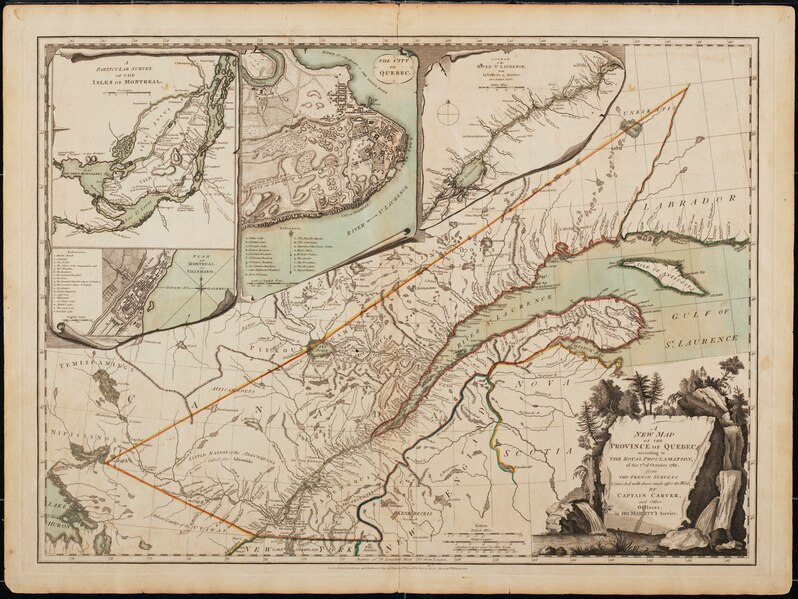
| A new map of the province of Quebec, according to the Royal Proclamation, of the 7th of October 1763. : From the French surveys connected with those made after the war.
( |
|
|---|---|
| Author |
|
| Title |
A new map of the province of Quebec, according to the Royal Proclamation, of the 7th of October 1763. : From the French surveys connected with those made after the war. |
| Publisher |
London. : Printed for Robt. Sayer and John Bennett, map and print sellers, No. 53 in Fleet Street, as the Act directs. |
| Description |
Subjects: North America -- Maps -- Early works to 1800.; Québec (Province) -- Maps -- Early works to 1800.; Montréal (Québec) -- Maps -- Early works to 1800.; Saint Lawrence River -- Maps -- Early works to 1800.; Great Britain -- Colonies -- America -- Maps -- Early works to 1800.; Canada -- Québec (Province) -- naf; McGill University Library Digitized Title; Canadian Maps Project; British colonies |
| Language | English |
| Publication date | 1776 |
| Current location |
IA Collections: mcgilluniversity; mcgilluniversityrarebooks; toronto |
| Accession number |
McGillLibrary-rbsc-maps_G3450_1763_C3-17131 |
| Source |
|
Licensing edit
|
This work is in the public domain in its country of origin and other countries and areas where the copyright term is the author's life plus 100 years or fewer. This work is in the public domain in the United States because it was published (or registered with the U.S. Copyright Office) before January 1, 1929. | |
| This file has been identified as being free of known restrictions under copyright law, including all related and neighboring rights. | |
File history
Click on a date/time to view the file as it appeared at that time.
| Date/Time | Thumbnail | Dimensions | User | Comment | |
|---|---|---|---|---|---|
| current | 04:55, 2 January 2021 |  | 4,360 × 3,275 (135.14 MB) | Fæ (talk | contribs) | IA Query "subject:maps date:[1000 TO 1869] " McGillLibrary-rbsc-maps_G3450_1763_C3-17131 Category:Old maps (COM:IA books#query) (retry 3) (1776 #200) |
You cannot overwrite this file.
File usage on Commons
The following page uses this file:
File usage on other wikis
The following other wikis use this file:
- Usage on fr.wikipedia.org