File:Aerial view of Tensaw River Bridge in local context, facing east, photograph taken from roof of First Bank of Mobile building - Tensaw River Lift Bridge, Spanning Tensaw River at U.S. HAER AL-104-1.tif

Size of this JPG preview of this TIF file: 740 × 599 pixels. Other resolutions: 296 × 240 pixels | 593 × 480 pixels | 949 × 768 pixels | 1,265 × 1,024 pixels | 2,529 × 2,048 pixels | 5,588 × 4,525 pixels.
Original file (5,588 × 4,525 pixels, file size: 24.12 MB, MIME type: image/tiff)
Captions
Captions
Add a one-line explanation of what this file represents
Summary edit
| Aerial view of Tensaw River Bridge in local context, facing east, photograph taken from roof of First Bank of Mobile building - Tensaw River Lift Bridge, Spanning Tensaw River at U.S. Highway 90, Mobile, Mobile County, AL | ||||
|---|---|---|---|---|
| Photographer |
Pratt, Daniel R. Related names:
|
|||
| Title |
Aerial view of Tensaw River Bridge in local context, facing east, photograph taken from roof of First Bank of Mobile building - Tensaw River Lift Bridge, Spanning Tensaw River at U.S. Highway 90, Mobile, Mobile County, AL |
|||
| Depicted place | Alabama; Mobile County; Mobile | |||
| Date | 1994 | |||
| Dimensions | 4 x 5 in. | |||
| Current location |
Library of Congress Prints and Photographs Division Washington, D.C. 20540 USA http://hdl.loc.gov/loc.pnp/pp.print |
|||
| Accession number |
HAER AL-104-1 |
|||
| Credit line |
|
|||
| Notes |
|
|||
| Source | https://www.loc.gov/pictures/item/al1158.photos.220840p | |||
| Permission (Reusing this file) |
|
|||

| Object location | | View this and other nearby images on: OpenStreetMap |
|---|
File history
Click on a date/time to view the file as it appeared at that time.
| Date/Time | Thumbnail | Dimensions | User | Comment | |
|---|---|---|---|---|---|
| current | 02:53, 1 July 2014 | 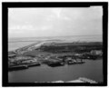 | 5,588 × 4,525 (24.12 MB) | Fæ (talk | contribs) | GWToolset: Creating mediafile for Fæ. HABS batch upload 29 June 2014 (101:150) |
You cannot overwrite this file.
File usage on Commons
The following page uses this file: