File:Amazon rainforest ESA23215661.jpeg

Original file (10,980 × 10,980 pixels, file size: 138.3 MB, MIME type: image/jpeg)
Captions
Captions
Summary edit
| Warning | The original file is very high-resolution. It might not load properly or could cause your browser to freeze when opened at full size. |
|---|
| Description |
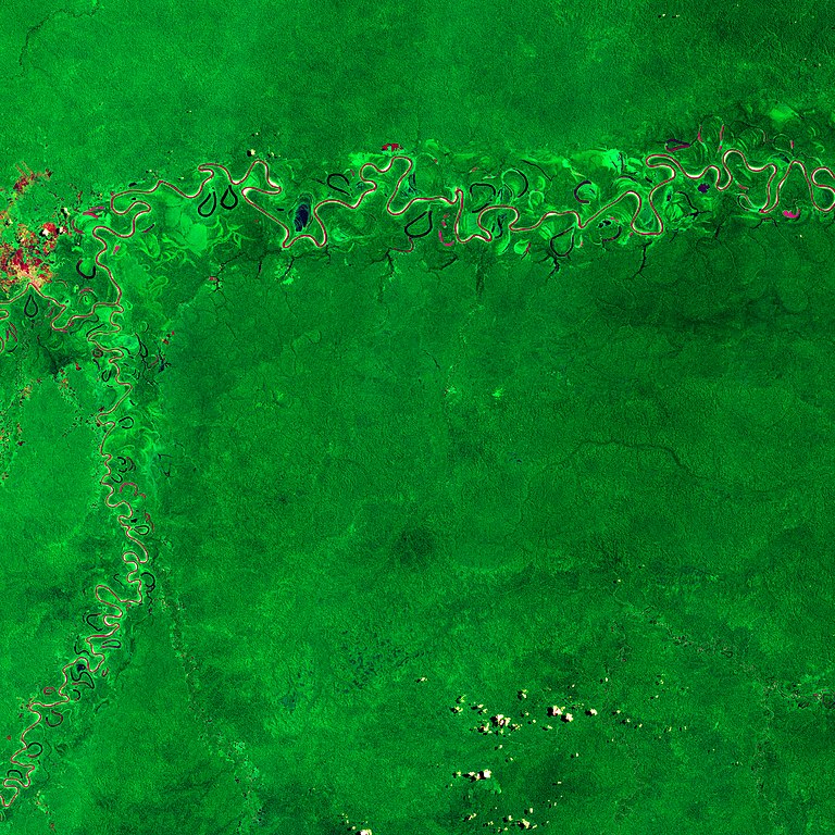
English: Ahead of the International Day of Forests, the Copernicus Sentinel-2 mission takes us over part of the Amazon rainforest in the Amazonas – the largest state in Brazil. Zoom in to see this image at its full 10 m resolution or click on the circles to learn more about the features in it. As its name implies, the Amazonas is almost entirely covered by the Amazon rainforest – the world’s largest tropical rainforest covering an area of around six million sq km. The Amazon is the world’s richest and most-varied biological reservoir, containing several million species of insects, birds, plants and other forms of life. This image has been processed using the infrared channel of the Sentinel-2 satellite which makes the dense rainforest appear in bright green. This makes differences in vegetation coverage more evident than only using the visible channels of the satellite that our eyes are able to see. In the top of the image, the Juruá River, the most-winding river in the Amazon basin, is visible. The river appears in shades of maroon and magenta as the reflected sunlight from the water’s surface consists of a mix of mainly blue and green, while the reflection in the near infrared is almost zero – leading to the colours we see here. The Juruá river, which flows more than 3000 km before emptying into the Amazon River, is turbid with relatively high nutrient levels. The river rises in the highlands in east-central Peru before winding its way through lowlands in Brazil. Several crescent-shaped oxbow lakes can be seen flanking the river. Oxbow lakes are generally formed when rivers cut through a meander ‘neck’ to shorten its course, causing the old channel to be blocked off – migrating away from the lake and creating a more direct route. The Tarauacá River, a tributary of Juruá, can be seen in the left of the image. Eirunepé, a settlement established in the 19th Century as a hub for rubber production, is visible in the top-left of the image. The 21 March marks the International Day of Forests – a day which seeks to raise awareness on a range of benefits that sustainably managed forests can contribute to our lives. According to the United Nations, the world is losing 10 million hectares of forest each year, which accounts for 12-20% of the global greenhouse gas emissions that contribute to climate change. The Amazon rainforest is crucial for helping to regulate global warming as the forests absorb millions of tonnes of carbon emissions every year. As plants grow, they remove carbon dioxide from the atmosphere and store it as biomass. This is then released back to the atmosphere through processes such as deforestation for agriculture and wildfires. Tracking biomass changes is key to understanding the global carbon cycle and also for informing global climate models that help predict future change. Earth observation satellites have been instrumental in helping our understanding of this important process. New maps produced by ESA’s Climate Change Initiative, provide a global view of above ground biomass are pertinent in helping to support forest management, emissions reduction and sustainable development policy goals. ESA’s upcoming Biomass mission will provide crucial information about the state of our forests and how they are changing. The satellite will pierce through woodland canopies to perform a global survey of Earth’s forests over the course of Biomass’s mission. This image is also featured on the Earth from Space video programme. |
| Date | 19 March 2021 (upload date) |
| Source | Amazon rainforest |
| Author | European Space Agency |
| Other versions |
|
| Activity | Observing the Earth |
| Mission | Sentinel-2 |
| Set | Earth observation image of the week |
| System | Copernicus |

Licensing edit

|
This image contains data from a satellite in the Copernicus Programme, such as Sentinel-1, Sentinel-2 or Sentinel-3. Attribution is required when using this image.
Attribution: Contains modified Copernicus Sentinel data 2019
The use of Copernicus Sentinel Data is regulated under EU law (Commission Delegated Regulation (EU) No 1159/2013 and Regulation (EU) No 377/2014). Relevant excerpts:
Free access shall be given to GMES dedicated data [...] made available through GMES dissemination platforms [...].
Access to GMES dedicated data [...] shall be given for the purpose of the following use in so far as it is lawful:
GMES dedicated data [...] may be used worldwide without limitations in time.
GMES dedicated data and GMES service information are provided to users without any express or implied warranty, including as regards quality and suitability for any purpose. |
This media was created by the European Space Agency (ESA).
Where expressly so stated, images or videos are covered by the Creative Commons Attribution-ShareAlike 3.0 IGO (CC BY-SA 3.0 IGO) licence, ESA being an Intergovernmental Organisation (IGO), as defined by the CC BY-SA 3.0 IGO licence. The user is allowed under the terms and conditions of the CC BY-SA 3.0 IGO license to Reproduce, Distribute and Publicly Perform the ESA images and videos released under CC BY-SA 3.0 IGO licence and the Adaptations thereof, without further explicit permission being necessary, for as long as the user complies with the conditions and restrictions set forth in the CC BY-SA 3.0 IGO licence, these including that:
See the ESA Creative Commons copyright notice for complete information, and this article for additional details.
|
 | |
This file is licensed under the Creative Commons Attribution-ShareAlike 3.0 IGO license. Attribution: ESA, CC BY-SA IGO 3.0
| ||
File history
Click on a date/time to view the file as it appeared at that time.
| Date/Time | Thumbnail | Dimensions | User | Comment | |
|---|---|---|---|---|---|
| current | 12:36, 19 March 2021 | | 10,980 × 10,980 (138.3 MB) | Don-vip (talk | contribs) | c:User:Rillke/bigChunkedUpload.js: |
| 09:28, 19 March 2021 |  | 2,000 × 2,000 (1.69 MB) | OptimusPrimeBot (talk | contribs) | #Spacemedia - Upload of https://www.esa.int/var/esa/storage/images/esa_multimedia/images/2021/03/amazon_rainforest/23215650-1-eng-GB/Amazon_rainforest.jpg via Commons:Spacemedia |
You cannot overwrite this file.
File usage on Commons
The following page uses this file: