File:Ancient Egypt map-la.svg

Size of this PNG preview of this SVG file: 293 × 598 pixels. Other resolutions: 117 × 240 pixels | 235 × 480 pixels | 376 × 768 pixels | 501 × 1,024 pixels | 1,003 × 2,048 pixels | 1,577 × 3,219 pixels.
Original file (SVG file, nominally 1,577 × 3,219 pixels, file size: 1.57 MB)
Captions
Captions
Add a one-line explanation of what this file represents
Summary edit
This W3C-unspecified vector image was created with Inkscape .
| Description |
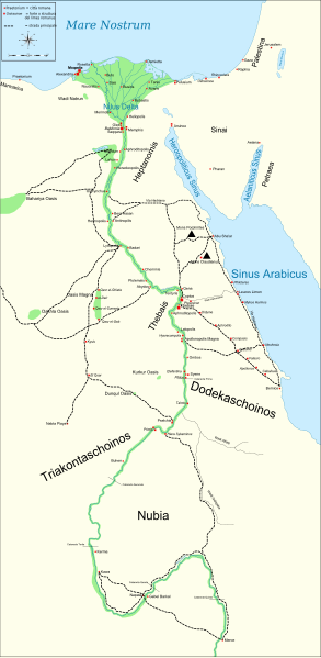
English: Map of Ancient Egypt, showing the Nile up to the fifth cataract, and major cities and sites of the Dynastic period (c. 3150 BC to 30 BC). Jerusalem is shown as reference cities. |
| Date | |
| Source |
Own work. See #References for references used creating the map. |
| Author | Gigillo83 |
| Other versions |
[]
|


|
This SVG file contains embedded text that can be translated into your language, using any capable SVG editor, text editor or the SVG Translate tool. For more information see: About translating SVG files. |
Licensing edit
I, the copyright holder of this work, hereby publish it under the following licenses:

|
Permission is granted to copy, distribute and/or modify this document under the terms of the GNU Free Documentation License, Version 1.2 or any later version published by the Free Software Foundation; with no Invariant Sections, no Front-Cover Texts, and no Back-Cover Texts. A copy of the license is included in the section entitled GNU Free Documentation License. |
This file is licensed under the Creative Commons Attribution-Share Alike Attribution-Share Alike 4.0 International, 3.0 Unported, 2.5 Generic, 2.0 Generic and 1.0 Generic license.
- You are free:
- to share – to copy, distribute and transmit the work
- to remix – to adapt the work
- Under the following conditions:
- attribution – You must give appropriate credit, provide a link to the license, and indicate if changes were made. You may do so in any reasonable manner, but not in any way that suggests the licensor endorses you or your use.
- share alike – If you remix, transform, or build upon the material, you must distribute your contributions under the same or compatible license as the original.
You may select the license of your choice.
References edit
Resources used to create the map:
- Shaw, Ian , ed. (2003) The Oxford History of Ancient Egypt, Oxford University Press ISBN: 0-19-280293-3.
- Dr. Peter Der Manuelian , ed. (1998) Egypt: The World of the Pharaohs, Bonner Straße, Köln (Deutschland): Könemann Verlagsgesellschaft mbH ISBN: 3-89508-913-3.
- Digital Egypt - maps. Retrieved on 2007-11-25.
- NASA PIA04957. Retrieved on 2007-11-25.
- NASA PIA02647. Retrieved on 2007-11-25.
- NASA PIA04965. Retrieved on 2007-11-25.
Reference coordinates:
- Sais 30°57′53″N, 30°46′6″E
- Buto 31°11′47″N, 30°44′41″E
- Alexandria 31°11′53″N 29°55′09″E
- Naukratis 30°54' N 30°35'E coordinates here
- Tanis 30°58′37″N, 31°52′48″E
- Avaris 30°47′N, 31°50′E
- Busiris 30°54′40″N, 31°14′40″E
Original upload log edit
The original description page is/was here. All following user names refer to Commons.
- 2009-01-29 13:21 Bibi Saint-Pol 1577×3219×0 (412000 bytes) (remove wrong text, adjust frame)
- 2009-01-29 12:47 Bibi Saint-Pol 1577×3219×0 (413000 bytes) (added frame)
- 2009-01-29 12:35 Bibi Saint-Pol 1577×3219×0 (412000 bytes) (harmonize colors with the standards + replace unsupported Arial fonts by DejaVu )
- 2008-02-11 06:55 Jeff Dahl 1577×3219×0 (391000 bytes) (sp fx)
- 2007-11-29 02:09 Jeff Dahl 1577×3219×0 (391000 bytes) (Rotate Mediterranean Sea label)
- 2007-11-27 23:32 Jeff Dahl 1577×3219×0 (391000 bytes) (Minor adjustments to Naukratis and Buto)
- 2007-11-27 18:59 Jeff Dahl 1577×3219×0 (391000 bytes) (Cairo and Jerusalem now with black dots/italics)
- 2007-11-23 00:04 Jeff Dahl 1577×3219×0 (391000 bytes) (fx scalebar)
- 2007-11-22 23:56 Jeff Dahl 1577×3219×0 (391000 bytes) ({{Information |Description=A map of ancient Egypt, made with Inkscape |Source=self-made |Date=11-22-07 |Author= Jeff Dahl |Permission= |other_versions={{DerivativeVersions|Ancient Egypt map-ru.svg}} }} )
File history
Click on a date/time to view the file as it appeared at that time.
| Date/Time | Thumbnail | Dimensions | User | Comment | |
|---|---|---|---|---|---|
| current | 21:54, 1 March 2010 | | 1,577 × 3,219 (1.57 MB) | Gigillo83 (talk | contribs) | Fix write |
| 15:26, 20 January 2010 |  | 1,577 × 3,219 (446 KB) | Gigillo83 (talk | contribs) | Aggiungo strada | |
| 14:59, 20 January 2010 |  | 1,577 × 3,219 (444 KB) | Gigillo83 (talk | contribs) | Aggiunti nomi e corretti luoghi | |
| 12:37, 17 January 2010 |  | 1,577 × 3,219 (414 KB) | Gigillo83 (talk | contribs) | Aggiunte vie e impianti militari | |
| 11:53, 6 January 2010 |  | 1,577 × 3,219 (407 KB) | Gigillo83 (talk | contribs) | == {{int:filedesc}} == {{inkscape}} {{Information |Description= {{en|Map of Ancient Egypt, showing the Nile up to the fifth cataract, and major cities and sites of the Dynastic period (c. 3150 BC to 30 BC). Jerusalem is shown as reference cities.}} |Sourc |
You cannot overwrite this file.
File usage on Commons
The following 28 pages use this file:
- File:Ancient Egypt map-af.svg
- File:Ancient Egypt map-ar.png
- File:Ancient Egypt map-de.svg
- File:Ancient Egypt map-el.svg
- File:Ancient Egypt map-en.svg
- File:Ancient Egypt map-es.svg
- File:Ancient Egypt map-fr.svg
- File:Ancient Egypt map-hiero.svg
- File:Ancient Egypt map-it.svg
- File:Ancient Egypt map-la.png
- File:Ancient Egypt map-la.svg
- File:Ancient Egypt map-lat.svg (file redirect)
- File:Ancient Egypt map-mk.svg
- File:Ancient Egypt map-nl.svg
- File:Ancient Egypt map-no.svg
- File:Ancient Egypt map-pl.svg
- File:Ancient Egypt map-pt.svg
- File:Ancient Egypt map-ru.svg
- File:Ancient Egypt map-sk.svg
- File:Ancient Egypt map-sr.svg
- File:Ancient Egypt map-vi.svg
- File:Ancient Egypt map-zh-hans.svg
- File:Antik Mısır haritası.png
- File:Antzinako Egipto.svg
- File:Mapo de antikva Egiptio.jpg
- File:Mapo de antikva Egiptio - centro.jpg
- File:Muistne Egiptus.png
- Template:Other versions/Ancient Egypt map
File usage on other wikis
The following other wikis use this file:
- Usage on bg.wikipedia.org
- Usage on cv.wikipedia.org
- Usage on el.wikipedia.org
- Usage on en.wikipedia.org
- Usage on es.wikipedia.org
- Usage on fr.wikipedia.org
- Usage on he.wikipedia.org
- Usage on it.wikipedia.org
- Limes (storia romana)
- Egitto (provincia romana)
- Prefetto d'Egitto
- Dodecascheno
- Augusto
- Campagne augustee lungo il fronte africano ed arabico
- Limes africano
- Progetto:Laboratorio grafico/Immagini da migliorare/Archivio risolte/39
- Via Hadriana
- Classis Alexandrina
- Politica estera di Augusto
- Utente:Barjimoa/SandboxP
- Usage on la.wikipedia.org
- Usage on mk.wikipedia.org
- Usage on nl.wikipedia.org
- Usage on pl.wikipedia.org
- Usage on ru.wikipedia.org
- Usage on uk.wikipedia.org
- Usage on www.wikidata.org