File:BattleOfBeaufortApproach.png
Size of this preview: 800 × 576 pixels. Other resolutions: 320 × 230 pixels | 640 × 461 pixels | 1,024 × 738 pixels | 1,144 × 824 pixels.
Original file (1,144 × 824 pixels, file size: 2.4 MB, MIME type: image/png)
Captions
Captions
Add a one-line explanation of what this file represents
Summary
edit
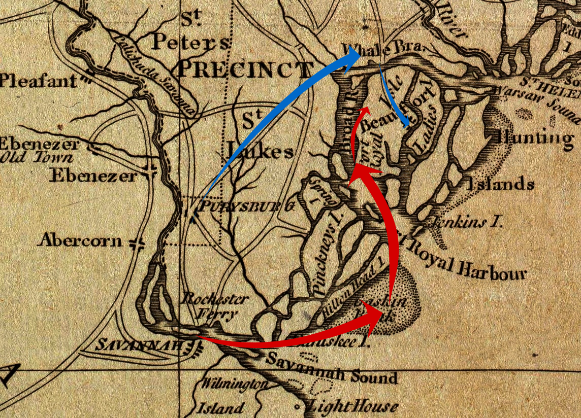
| Description | A period map annotated to show military movements prior to the 1779 Battle of Beaufort, South Carolina. American movements are in blue, British movements in red. |
| Date | Base map: 1779; annotations: 2012 |
| Source |
Base map: Boston Public Library Map Collection: http://maps.bpl.org/details_14504/ Annotations: Own work |
| Author | Base map: Joseph Hinton; annotations: User:Magicpiano |
| Permission (Reusing this file) |
Public domain |
| I, the copyright holder of this work, release this work into the public domain. This applies worldwide. In some countries this may not be legally possible; if so: I grant anyone the right to use this work for any purpose, without any conditions, unless such conditions are required by law. |
Licensing
edit
This media file is in the public domain in the United States. This applies to U.S. works where the copyright has expired, often because its first publication occurred prior to January 1, 1929, and if not then due to lack of notice or renewal. See this page for further explanation.
|
 | |
 |
File history
Click on a date/time to view the file as it appeared at that time.
| Date/Time | Thumbnail | Dimensions | User | Comment | |
|---|---|---|---|---|---|
| current | 19:05, 13 January 2012 | | 1,144 × 824 (2.4 MB) | Magicpiano (talk | contribs) | Level adjustments on background image. |
| 16:23, 13 January 2012 |  | 1,144 × 824 (1.83 MB) | Magicpiano (talk | contribs) | {{Information |Description=A period map annotated to show military movements prior to the 1779 w:Battle of Beaufort, South Carolina. American movements are in blue, British movements in red. |Source=Base map: Boston Public Library Map Collection: ht |
You cannot overwrite this file.
File usage on Commons
There are no pages that use this file.
File usage on other wikis
The following other wikis use this file:
- Usage on en.wikipedia.org
- Usage on ja.wikipedia.org
- Usage on nl.wikipedia.org
- Usage on www.wikidata.org
- Usage on zh.wikipedia.org