File:BiH1991a.png

Size of this preview: 633 × 600 pixels. Other resolutions: 253 × 240 pixels | 507 × 480 pixels | 811 × 768 pixels | 1,081 × 1,024 pixels | 1,780 × 1,686 pixels.
Original file (1,780 × 1,686 pixels, file size: 264 KB, MIME type: image/png)
Captions
Captions
Add a one-line explanation of what this file represents
Summary edit
| Description |
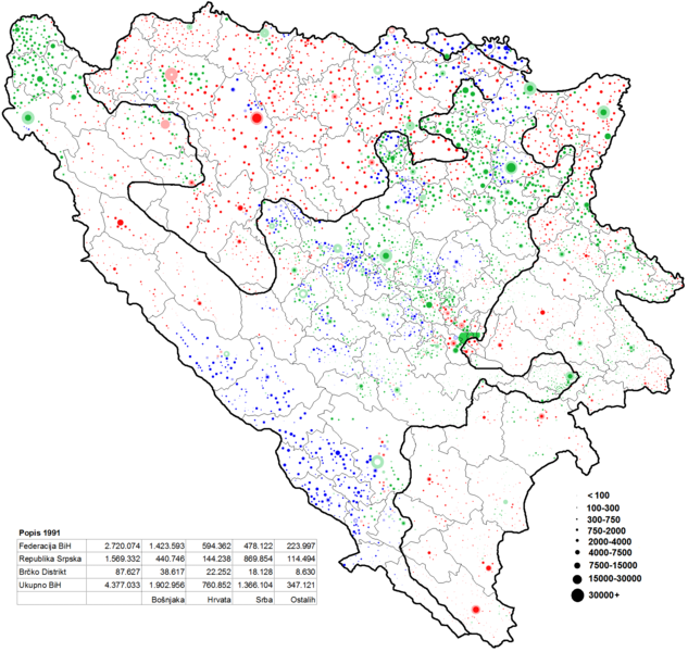
Hrvatski: Etnicka karta Bosne i Hercegovine po naseljenim mjestima i po popisu iz 1991-e English: Ethnic map of Bosnia and Herzegovina acording to 1991 cenzus |
| Date | |
| Source | Own work |
| Author | Sigra35 |
Licensing edit
I, the copyright holder of this work, hereby publish it under the following license:
This file is licensed under the Creative Commons Attribution-Share Alike 3.0 Unported license.
- You are free:
- to share – to copy, distribute and transmit the work
- to remix – to adapt the work
- Under the following conditions:
- attribution – You must give appropriate credit, provide a link to the license, and indicate if changes were made. You may do so in any reasonable manner, but not in any way that suggests the licensor endorses you or your use.
- share alike – If you remix, transform, or build upon the material, you must distribute your contributions under the same or compatible license as the original.
File history
Click on a date/time to view the file as it appeared at that time.
| Date/Time | Thumbnail | Dimensions | User | Comment | |
|---|---|---|---|---|---|
| current | 12:40, 1 November 2021 | | 1,780 × 1,686 (264 KB) | Sigra35 (talk | contribs) | Reverted to version as of 21:33, 25 January 2014 (UTC) |
| 11:59, 18 September 2020 |  | 1,780 × 1,686 (239 KB) | Ceha (talk | contribs) | Žepče, Vukosavlje, Stanari, Petrovo.... Granice općina | |
| 21:33, 25 January 2014 |  | 1,780 × 1,686 (264 KB) | Sigra35 (talk | contribs) | User created page with UploadWizard |
You cannot overwrite this file.
File usage on Commons
There are no pages that use this file.
File usage on other wikis
The following other wikis use this file:
- Usage on bg.wikipedia.org
- Usage on ur.wikipedia.org