File:CHIMNEY ON NORTH SIDE - Vogtner Farm (House and Smokehouse), Jeff Hamilton Road vicinity, Dawes, Mobile County, AL HABS ALA,49-DAW,1-4.tif
Size of this JPG preview of this TIF file: 432 × 599 pixels. Other resolutions: 173 × 240 pixels | 346 × 480 pixels | 554 × 768 pixels | 738 × 1,024 pixels | 1,477 × 2,048 pixels | 3,606 × 5,000 pixels.
Original file (3,606 × 5,000 pixels, file size: 17.2 MB, MIME type: image/tiff)
Captions
Captions
Add a one-line explanation of what this file represents
Summary edit
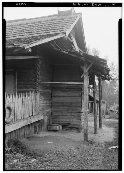
| Historic American Buildings Survey E. W. Russell, Photographer, January 15, 1937 CHIMNEY ON NORTH SIDE - Vogtner Farm (House and Smokehouse), Jeff Hamilton Road vicinity, Dawes, Mobile County, AL | ||||
|---|---|---|---|---|
| Title |
Historic American Buildings Survey E. W. Russell, Photographer, January 15, 1937 CHIMNEY ON NORTH SIDE - Vogtner Farm (House and Smokehouse), Jeff Hamilton Road vicinity, Dawes, Mobile County, AL |
|||
| Depicted place | Alabama; Mobile County; Dawes | |||
| Date | Documentation compiled after 1933 | |||
| Medium | 5 x 7 in. | |||
| Current location |
Library of Congress Prints and Photographs Division Washington, D.C. 20540 USA http://hdl.loc.gov/loc.pnp/pp.print |
|||
| Accession number |
HABS ALA,49-DAW,1-4 |
|||
| Credit line |
|
|||
| Notes |
|
|||
| Source | https://www.loc.gov/pictures/item/al0383.photos.004208p | |||
| Permission (Reusing this file) |
|
|||

| Object location | | View this and other nearby images on: OpenStreetMap |
|---|
File history
Click on a date/time to view the file as it appeared at that time.
| Date/Time | Thumbnail | Dimensions | User | Comment | |
|---|---|---|---|---|---|
| current | 09:52, 29 June 2014 |  | 3,606 × 5,000 (17.2 MB) | Fæ (talk | contribs) | GWToolset: Creating mediafile for Fæ. HABS batch upload restart 26 June 2014 (p21:101)x |
You cannot overwrite this file.
File usage on Commons
The following page uses this file: