File:CLOSE-IN DETAIL VIEW OF TRUSS ENDS RESTING ON PIER, SHOWING BOTTOM CHORD CONNECTIONS - Scioto Pennsylvania Through Truss Bridge, Spanning Scioto River at State Route 73, HAER OHIO,73-PORT,1-7.tif
Size of this JPG preview of this TIF file: 479 × 600 pixels. Other resolutions: 192 × 240 pixels | 383 × 480 pixels | 613 × 768 pixels | 818 × 1,024 pixels | 1,636 × 2,048 pixels | 3,772 × 4,723 pixels.
Original file (3,772 × 4,723 pixels, file size: 16.99 MB, MIME type: image/tiff)
Captions
Captions
Add a one-line explanation of what this file represents
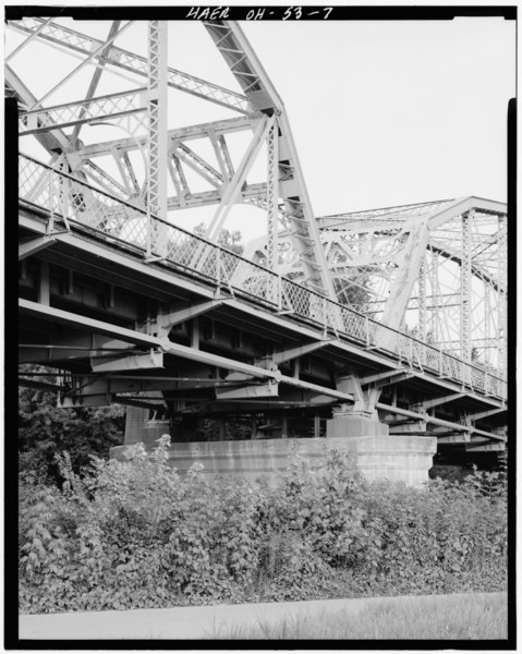
| CLOSE-IN DETAIL VIEW OF TRUSS ENDS RESTING ON PIER, SHOWING BOTTOM CHORD CONNECTIONS - Scioto Pennsylvania Through Truss Bridge, Spanning Scioto River at State Route 73, Portsmouth, Scioto County, OH | ||||
|---|---|---|---|---|
| Photographer |
Related names:
|
|||
| Title |
CLOSE-IN DETAIL VIEW OF TRUSS ENDS RESTING ON PIER, SHOWING BOTTOM CHORD CONNECTIONS - Scioto Pennsylvania Through Truss Bridge, Spanning Scioto River at State Route 73, Portsmouth, Scioto County, OH |
|||
| Depicted place | Ohio; Scioto County; Portsmouth | |||
| Date | Documentation compiled after 1968 | |||
| Dimensions | 4 x 5 in. | |||
| Current location |
Library of Congress Prints and Photographs Division Washington, D.C. 20540 USA http://hdl.loc.gov/loc.pnp/pp.print |
|||
| Accession number |
HAER OHIO,73-PORT,1-7 |
|||
| Credit line |
|
|||
| Notes |
|
|||
| Source | https://www.loc.gov/pictures/item/oh1484.photos.128508p | |||
| Permission (Reusing this file) |
|
|||

| Object location | | View this and other nearby images on: OpenStreetMap |
|---|
File history
Click on a date/time to view the file as it appeared at that time.
| Date/Time | Thumbnail | Dimensions | User | Comment | |
|---|---|---|---|---|---|
| current | 14:23, 30 July 2014 |  | 3,772 × 4,723 (16.99 MB) | Fæ (talk | contribs) | GWToolset: Creating mediafile for Fæ. HABS 30 July 2014 (2601:2900) |
You cannot overwrite this file.
File usage on Commons
The following page uses this file: