File:CLOSE-UP VIEW OF MID-SECTION OF TOWER, SHOWING RIVETED CONNECTIONS AND ADJUSTABLE TIE-RODS, LOOKING NORTHWEST - Valley Forge Observation Tower, King of Prussia, Montgomery County, HAER PA,46-VALFO,4-9.tif

Size of this JPG preview of this TIF file: 481 × 600 pixels. Other resolutions: 192 × 240 pixels | 385 × 480 pixels | 616 × 768 pixels | 821 × 1,024 pixels | 1,643 × 2,048 pixels | 4,011 × 5,000 pixels.
Original file (4,011 × 5,000 pixels, file size: 19.13 MB, MIME type: image/tiff)
Captions
Captions
Add a one-line explanation of what this file represents
Summary edit
| CLOSE-UP VIEW OF MID-SECTION OF TOWER, SHOWING RIVETED CONNECTIONS AND ADJUSTABLE TIE-RODS, LOOKING NORTHWEST - Valley Forge Observation Tower, King of Prussia, Montgomery County, PA | ||||
|---|---|---|---|---|
| Title |
CLOSE-UP VIEW OF MID-SECTION OF TOWER, SHOWING RIVETED CONNECTIONS AND ADJUSTABLE TIE-RODS, LOOKING NORTHWEST - Valley Forge Observation Tower, King of Prussia, Montgomery County, PA |
|||
| Description |
Variety Iron Works of Cleveland,Ohio; Cope, Emmor B; Ingle, John; Eisenman, George, photographer; Marshall-Dutcher, Joan, historian |
|||
| Depicted place | Pennsylvania; Montgomery County; King of Prussia | |||
| Date | Documentation compiled after 1968 | |||
| Dimensions | 5 x 7 in. | |||
| Current location |
Library of Congress Prints and Photographs Division Washington, D.C. 20540 USA http://hdl.loc.gov/loc.pnp/pp.print |
|||
| Accession number |
HAER PA,46-VALFO,4-9 |
|||
| Credit line |
|
|||
| Notes |
|
|||
| References |
|
|||
| Source | https://www.loc.gov/pictures/item/pa1776.photos.136241p | |||
| Permission (Reusing this file) |
|
|||

| Object location | | View this and other nearby images on: OpenStreetMap |
|---|
File history
Click on a date/time to view the file as it appeared at that time.
| Date/Time | Thumbnail | Dimensions | User | Comment | |
|---|---|---|---|---|---|
| current | 23:39, 30 July 2014 | 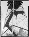 | 4,011 × 5,000 (19.13 MB) | Fæ (talk | contribs) | GWToolset: Creating mediafile for Fæ. HABS 30 July 2014 (2901:3000) |
You cannot overwrite this file.
File usage on Commons
The following page uses this file: