File:Congo Democratic Republic Map.jpg

Size of this preview: 542 × 600 pixels. Other resolutions: 217 × 240 pixels | 434 × 480 pixels | 694 × 768 pixels | 1,070 × 1,184 pixels.
Original file (1,070 × 1,184 pixels, file size: 252 KB, MIME type: image/jpeg)
Captions
Captions
Add a one-line explanation of what this file represents
| Description | ||||
| Date | ||||
| Source | [1] from the Perry-Castañeda Library Map Collection. | |||
| Author | CIA | |||
| Permission (Reusing this file) |
|

![[1]](http://www.lib.utexas.edu/maps/africa/congo_demrep_rel98.jpg)
File history
Click on a date/time to view the file as it appeared at that time.
| Date/Time | Thumbnail | Dimensions | User | Comment | |
|---|---|---|---|---|---|
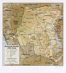
| current | 12:05, 21 February 2006 | | 1,070 × 1,184 (252 KB) | Lupo (talk | contribs) | Shaded relief map of the Democratic Republic of the Congo (the former Zaire). Source: [http://www.lib.utexas.edu/maps/africa/congo_demrep_rel98.jpg] from the [http://www.lib.utexas.edu/maps/zaire.html Perry-Castañeda Library Map Collection]. {{ |
You cannot overwrite this file.
File usage on Commons
The following 4 pages use this file:
File usage on other wikis
The following other wikis use this file:
- Usage on de.wikipedia.org
- Usage on en.wikipedia.org
- Usage on es.wikipedia.org
- Usage on it.wikipedia.org
- Usage on lt.wikipedia.org
- Usage on pl.wikipedia.org
- Usage on uk.wikipedia.org
- Usage on vec.wikipedia.org
- Usage on zh.wikipedia.org