File:Credit PSR. The interior of the grinder room appears as seen looking southeast (148°), showing the remaining grinder equipment in the building. Note the blow-out wall HAER CAL,15-BORON.V,1O-2.tif

Size of this JPG preview of this TIF file: 478 × 599 pixels. Other resolutions: 191 × 240 pixels | 383 × 480 pixels | 613 × 768 pixels | 817 × 1,024 pixels | 1,634 × 2,048 pixels | 4,436 × 5,560 pixels.
Original file (4,436 × 5,560 pixels, file size: 23.52 MB, MIME type: image/tiff)
Captions
Captions
Add a one-line explanation of what this file represents
Summary
edit| Title |
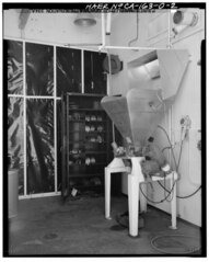
Credit PSR. The interior of the grinder room appears as seen looking southeast (148°), showing the remaining grinder equipment in the building. Note the blow-out wall in the background, and the water sprinkler head positioned over the hopper. The hopper top is connected to the dust receiver in the adjacent room. The blow-out wall is constructed to relieve pressure easily should an explosion occur, thus minimizing damage to the rest of the building structure. The floor has a conductive coating which dissipates static electrical charges that might otherwise cause fires - Jet Propulsion Laboratory Edwards Facility, Oxidizer Grinder Building, Edwards Air Force Base, Boron, Kern County, CA |
|||
| Depicted place | California; Kern County; Boron | |||
| Date | Documentation compiled after 1968 | |||
| Dimensions | 4 x 5 in. | |||
| Current location |
Library of Congress Prints and Photographs Division Washington, D.C. 20540 USA http://hdl.loc.gov/loc.pnp/pp.print |
|||
| Accession number |
HAER CAL,15-BORON.V,1O-2 |
|||
| Credit line |
|
|||
| Notes |
|
|||
| Source | https://www.loc.gov/pictures/item/ca3009.photos.382275p | |||
| Permission (Reusing this file) |
|

| Object location | | View this and other nearby images on: OpenStreetMap |
|---|
File history
Click on a date/time to view the file as it appeared at that time.
| Date/Time | Thumbnail | Dimensions | User | Comment | |
|---|---|---|---|---|---|
| current | 02:54, 6 July 2014 |  | 4,436 × 5,560 (23.52 MB) | Fæ (talk | contribs) | GWToolset: Creating mediafile for Fæ. HABS 05 July 2014 (501:600) |
You cannot overwrite this file.
File usage on Commons
The following 2 pages use this file:
- File:Credit PSR. The interior of the grinder room appears as seen looking southeast (148and-176;), showing the remaining grinder equipment in the building. Note the blow-out wall HAER CAL,15-BORON.V,1O-2.tif (file redirect)
- File:Credit PSR. The interior of the grinder room appears as seen looking southeast (148°), showing the remaining grinder equipment in the building. Note the blow-out wall HAER CAL,15-BORON.V,1O-2.tif