File:Croatia population density map 2011 by county.svg

Size of this PNG preview of this SVG file: 619 × 599 pixels. Other resolutions: 248 × 240 pixels | 496 × 480 pixels | 793 × 768 pixels | 1,058 × 1,024 pixels | 2,115 × 2,048 pixels | 1,098 × 1,063 pixels.
Original file (SVG file, nominally 1,098 × 1,063 pixels, file size: 584 KB)
Captions
Captions
Add a one-line explanation of what this file represents
Summary edit
| Description |
العربية: الكثافة السكانية في كرواتيا حسب المقاطعة بالأشخاص لكل كم² عام 2011.
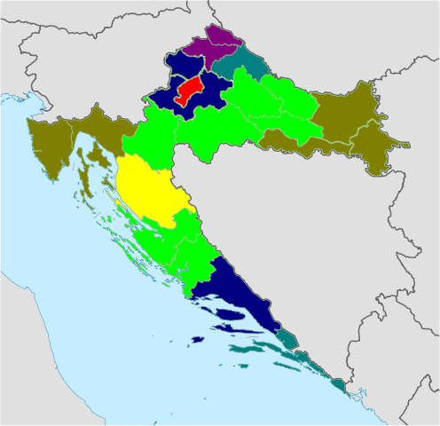
English: Croatia population density map by county (2011) - Croatian Bureau of Statistics 2011 census data |
| Date | |
| Source | Own work using file:Croatia location map.svg by NordNordWest |
| Author | Tomobe03 |
Licensing edit
I, the copyright holder of this work, hereby publish it under the following license:
This file is licensed under the Creative Commons Attribution-Share Alike 3.0 Unported license.
- You are free:
- to share – to copy, distribute and transmit the work
- to remix – to adapt the work
- Under the following conditions:
- attribution – You must give appropriate credit, provide a link to the license, and indicate if changes were made. You may do so in any reasonable manner, but not in any way that suggests the licensor endorses you or your use.
- share alike – If you remix, transform, or build upon the material, you must distribute your contributions under the same or compatible license as the original.
File history
Click on a date/time to view the file as it appeared at that time.
| Date/Time | Thumbnail | Dimensions | User | Comment | |
|---|---|---|---|---|---|
| current | 12:21, 7 November 2011 | | 1,098 × 1,063 (584 KB) | Tomobe03 (talk | contribs) |
You cannot overwrite this file.
File usage on Commons
There are no pages that use this file.
File usage on other wikis
The following other wikis use this file:
- Usage on ar.wikipedia.org
- Usage on el.wikipedia.org
- Usage on en.wikipedia.org
- Usage on ja.wikipedia.org
- Usage on ru.wikipedia.org
- Usage on sr.wikipedia.org