File:DETAIL MIDSPAN, SOUTH PANEL. - Kenyon Bridge, Spanning Mill Brook, Town House Road, Cornish City, Sullivan County, NH HAER NH-40-9.tif

Size of this JPG preview of this TIF file: 426 × 600 pixels. Other resolutions: 170 × 240 pixels | 341 × 480 pixels | 546 × 768 pixels | 727 × 1,024 pixels | 1,455 × 2,048 pixels | 3,651 × 5,138 pixels.
Original file (3,651 × 5,138 pixels, file size: 17.89 MB, MIME type: image/tiff)
Captions
Captions
Add a one-line explanation of what this file represents
Summary edit
| DETAIL MIDSPAN, SOUTH PANEL. - Kenyon Bridge, Spanning Mill Brook, Town House Road, Cornish City, Sullivan County, NH | ||||
|---|---|---|---|---|
| Photographer |
Lowe, Jet Related names:
|
|||
| Title |
DETAIL MIDSPAN, SOUTH PANEL. - Kenyon Bridge, Spanning Mill Brook, Town House Road, Cornish City, Sullivan County, NH |
|||
| Depicted place | New Hampshire; Sullivan County; Cornish City | |||
| Date | 2003 | |||
| Dimensions | 5 x 7 in. | |||
| Current location |
Library of Congress Prints and Photographs Division Washington, D.C. 20540 USA http://hdl.loc.gov/loc.pnp/pp.print |
|||
| Accession number |
HAER NH-40-9 |
|||
| Credit line |
|
|||
| Notes |
|
|||
| References |
|
|||
| Source | https://www.loc.gov/pictures/item/nh0279.photos.198784p | |||
| Permission (Reusing this file) |
|
|||

| Object location | | View this and other nearby images on: OpenStreetMap |
|---|
File history
Click on a date/time to view the file as it appeared at that time.
| Date/Time | Thumbnail | Dimensions | User | Comment | |
|---|---|---|---|---|---|
| current | 06:26, 29 July 2014 | 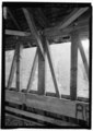 | 3,651 × 5,138 (17.89 MB) | Fæ (talk | contribs) | GWToolset: Creating mediafile for Fæ. HABS 24 July 2014 (2001:2300) |
You cannot overwrite this file.
File usage on Commons
The following page uses this file:
File usage on other wikis
The following other wikis use this file:
- Usage on en.wikipedia.org