File:DOWNSTREAM VIEW OF HISTORIC OUTLET WORKS TAKEN FROM THE NORTH BANK OF THE CHANNEL BETWEEN THE OLD WORKS AND TWIN LAKES DAM. VIEW LOOKING WEST. - Twin Lakes Dam and Outlet Works HAER COLO,34-TWLK.V,1-4.tif

Size of this JPG preview of this TIF file: 753 × 600 pixels. Other resolutions: 302 × 240 pixels | 603 × 480 pixels | 965 × 768 pixels | 1,280 × 1,019 pixels | 2,560 × 2,038 pixels | 5,000 × 3,981 pixels.
Original file (5,000 × 3,981 pixels, file size: 18.99 MB, MIME type: image/tiff)
Captions
Captions
Add a one-line explanation of what this file represents
Summary edit
| Photographer |
Related names:
|
|||
| Title |
DOWNSTREAM VIEW OF HISTORIC OUTLET WORKS TAKEN FROM THE NORTH BANK OF THE CHANNEL BETWEEN THE OLD WORKS AND TWIN LAKES DAM. VIEW LOOKING WEST. - Twin Lakes Dam and Outlet Works, Beneath Twin Lakes Reservoir, T11S, R80W, S22, Twin Lakes, Lake County, CO |
|||
| Depicted place | Colorado; Lake County; Twin Lakes | |||
| Date | Documentation compiled after 1968 | |||
| Dimensions | 4 x 5 in. | |||
| Current location |
Library of Congress Prints and Photographs Division Washington, D.C. 20540 USA http://hdl.loc.gov/loc.pnp/pp.print |
|||
| Accession number |
HAER COLO,34-TWLK.V,1-4 |
|||
| Credit line |
|
|||
| Notes |
|
|||
| Source | https://www.loc.gov/pictures/item/co0251.photos.183523p | |||
| Permission (Reusing this file) |
|

| Object location | | View this and other nearby images on: OpenStreetMap |
|---|
File history
Click on a date/time to view the file as it appeared at that time.
| Date/Time | Thumbnail | Dimensions | User | Comment | |
|---|---|---|---|---|---|
| current | 21:30, 8 July 2014 | 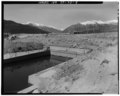 | 5,000 × 3,981 (18.99 MB) | Fæ (talk | contribs) | GWToolset: Creating mediafile for Fæ. HABS 05 July 2014 (501:600) |
You cannot overwrite this file.
File usage on Commons
The following page uses this file: